
Previous issues
- Page Path
- HOME > Articles and Issues > Previous issues
- Volume 4(3); September 2022
-


Articles
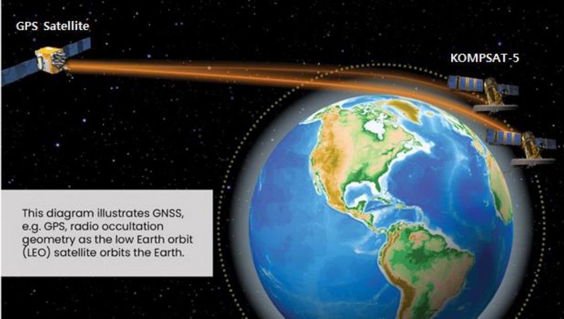
- KOMPSAT-5 GNSS Radio Occultation Data Operations
- Okchul Jung, Jaedong Seong, Myeongshin Lee, Daewon Chung
- GEO DATA. 2022;4(3):1-7. Published online September 30, 2022
- DOI: https://doi.org/10.22761/DJ2022.4.3.001
- 417 View
- 14 Download
-
 Abstract
 PDF
PDF - The Korea Aerospace Research Institute launched KOMPSAT-5 on August 22, 2013, and has been operating for 10 years. KOMPSAT-5 has SAR (Synthetic Aperture Radar) for earth observation missions, and collects data necessary for earth atmosphere analysis through GNSS RO (Radio Occultation) receivers. RO data can be used for numerical weather forecast model based on temperature, pressure, and humidity by calculating the vertical distribution of atmospheric information. As a part of the Korea-US science and technology cooperation, KARI has been providing RO data of KOMPSAT-5 to the United States NOAA (National Oceanic and Atmospheric Administration) in near-real time since 2018. To this end, KARI receives telemetry data from the satellite about 12 times a day using 3 ground stations from Daejeon, Alaska in the U.S., and Sodankyla in Finland. The pre-processed data is being provided to both the UCAR (University Corporation for Atmospheric Research) in the U.S. and the KASI (Korea Astronomy and Space Science Institute). In this paper, radio occlusion data of KOMPSAT-5 is introduced, and system configuration, operation concepts for providing near-real time data and its application are also presented.
- Sea Surface CO2 Measurements on the R/V ISABU in the Northwestern Pacific in October 2019
- Nayeon Kang, Sosul Cho, Seon-Eun Lee
- GEO DATA. 2022;4(3):8-14. Published online September 30, 2022
- DOI: https://doi.org/10.22761/DJ2022.4.3.002

- 445 View
- 20 Download
-
Abstract
PDF
- The ocean takes up anthropogenic carbon dioxide (CO2) emitted into the atmosphere. The oceanic CO2 uptake shows seasonal and regional differences depending on numerous factors. We investigated distributions of atmospheric and sea surface CO2 in the Northwestern Pacific using the continuous underway pCO2 measuring system equipped on the Research Vessel ISABU of Korea Institute of Ocean Science and Technology. During the cruise, 3,597 data of seawater CO2 were obtained with sea surface temperature (SST), sea surface salinity (SSS), and GPS information for 13 days from October 4 to 17, 2019. Through the differences in CO2 concentrations between seawater and the atmosphere, we confirmed that CO2 concentrations of the sea surface were lower than those of the atmosphere in most of the surveyed areas. Higher SST and lower SSS were observed in the lower latitude area than 17°N in Philippine Sea, but latitudinal variation of CO2 concentration was not significant.
- Reconstruction of monthly fCO2 distribution in the Ross Sea, Antarctica during 1998 -2018 using machine learning technique and observational data sets
- Ahra Mo, Jung-ok Choi, Keyhong Park
- GEO DATA. 2022;4(3):15-24. Published online September 30, 2022
- DOI: https://doi.org/10.22761/DJ2022.4.3.003

- 490 View
- 20 Download
-
Abstract
PDF
- The ocean is a major reservoir of anthropogenic carbon dioxide, especially the Southern Ocean has been known to absorb 40% of the carbon dioxide emitted by human activity. The Ross Sea is one of the most productive regions in the Southern Ocean; however, its carbon dioxide absorption capacity has not been clearly evaluated yet. Because the Southern Ocean is geographically isolated from civilization and thus, its remoteness prevents making sufficient observations from proving reliable carbon dioxide sink strength estimates. Thus, in order to overcome the current spatial and temporal limitations of direct observations, the fugacity of carbon dioxide (fCO2) data was reproduced using a machine learning technique (i.e., random forest technique). The technique is a type of machine learning frequently used to reproduce marine environmental variations through training satellite data and modeled data as well as existing observational data. Furthermore, to reproduce more reliable fCO2 estimates, in addition to marine environmental variables (i.e., sea surface temperature, sea ice concentration, and chlorophyll-a concentration), cloud cover, wind speed, and El Niño index were included in the machine learning procedure. In this study, we provide the past 21 years (1998 – 2018) of monthly spatial and temporal variation information of dissolved carbon dioxide in the Ross Sea, Antarctica.
 First
First Prev
Prev


Editorial Office of GEO DATA

#816, 8-13, Gwangpyeong-ro 56-gil, Gangnam-gu, 06367 Seoul, South Korea
Tel: +82-2-6677-5682 E-mail: geodata@gaidas.org
Corporate registration number: 780-82-00418