
Articles
- Page Path
- HOME > GEO DATA > Volume 5(1); 2023 > Article
-
Original Paper
그린란드 러셀빙하 소형무인항공기 라이다 센서 기반 정밀 지형 데이터셋 -
정용식1
 , 이성재2, 김승희1, 김현철3,*
 - Small Unmanned Aerial Vehicle LiDAR-based High Spatial Resolution Topographic Dataset in Russell Glacier, Greenland
-
Yongsik Jeong1, Sungjae Lee2, Seung Hee Kim1, Hyun-Cheol Kim3,*
-
GEO DATA 2023;5(1):1-7.
DOI: https://doi.org/10.22761/GD.2023.0006
Published online: March 29, 2023
1선임연구원, 한국해양과학기술원 부설 극지연구소, 원격탐사빙권정보센터, 인천광역시 연수구 송도미래로 26, 21990, 대한민국
2기술원, 한국해양과학기술원 부설 극지연구소, 원격탐사빙권정보센터, 인천광역시 연수구 송도미래로 26, 21990, 대한민국
3책임연구원, 한국해양과학기술원 부설 극지연구소, 원격탐사빙권정보센터, 인천광역시 연수구 송도미래로 26, 21990, 대한민국
1Senior Research Scientist, Center of Remote Sensing and GIS, Korea Polar Research Institute (KOPRI), 26 Songdomirae-ro, Yeonsu-gu, 21990 Incheon, South Korea
2Administrative Specialist, Center of Remote Sensing and GIS, Korea Polar Research Institute (KOPRI), 26 Songdomirae-ro, Yeonsu-gu, 21990 Incheon, South Korea
3Principal Research Scientist, Center of Remote Sensing and GIS, Korea Polar Research Institute (KOPRI), 26 Songdomirae-ro, Yeonsu-gu, 21990 Incheon, South Korea
- Corresponding Author Hyun-Cheol Kim Tel: +82-32-760-5335 E-mail: kimhc@kopri.re.kr
Copyright © 2023 GeoAI Data Society
This is an Open Access article distributed under the terms of the Creative Commons Attribution Non-Commercial License (http://creativecommons.org/licenses/by-nc/3.0/) which permits unrestricted non-commercial use, distribution, and reproduction in any medium, provided the original work is properly cited.
- 1,569 Views
- 130 Download
Abstract
- Greenland contains a large continental glacier. The influence of glacier melting has been expanding due to global warming. Although regional monitoring based on satellite data is being conducted, the demand for local/specific variation observation has increased as rising climate temperature patterns in the polar region. In this study, a precise topographic dataset was created for Greenland’s Russell glacier using a small unmanned aerial vehicle (sUAV) onboarded LiDAR sensor. A precise digital surface model (DSM) was constructed based on LiDAR data obtained at an altitude of about 100 to 200 m, and DSM resampled to a 2 m sample distance was produced to confirm its applicability by comparing before-and-after variations. This study provides DSM data applied with a pre/post-processing used for the comparison analysis.
- 그린란드 대륙 빙하의 용융 및 가속화는 지구온난화로 인해 극지방 지역의 기온 상승에 따라 영향을 받는 것으로 National Snow and Ice Data Center (NSIDC)에서 보고한 바 있으며, 지표 빙상(ice sheet) mass balance 및 빙하 후퇴 변이-경향 분석을 기반으로 지속적인 모니터링과 관련된 연구 및 보고 내용이 발표되고 있다(King et al., 2020; Mottram et al., 2019; Mouginot et al., 2019; Sasgen et al., 2020). 특히 그린란드의 경우 지구 상에서 남극대륙 다음으로 많은 빙하로 이루어져 있으며, 이들의 용융지속에 의해 예상되는 해수면 상승 범주가 전 지구적 환경 변화 및 파괴에 많은 영향을 미칠 것으로 보고되고 있다. 기존의 관련 연구들은 인공위성 기반의 레이저고도계, 중력계, InSAR 등의 자료를 기반으로 수행되고 있으며, 수치고도모델(digital elevation model, DEM) 제작 및 활용은 장기간 빙하의 시계열 지형 변이 판단에 있어 필수적으로 이용되고 있다. 최근 활용 수요가 폭발적으로 증가하고 있는 소형무인기체(small unmanned aerial vehicle, sUAV)는 위성정보플랫폼과 비교하여 보다 상세한 공간정보를 제공할 수 있는 원격탐사 모니터링 기술력으로 여겨지고 있으며, 비용 대비 극대화된 효율성을 바탕으로 지역적 초고해상도 3차원 지형정보 측량 및 정보 획득 측면에서 유리한 장점을 제공한다(Jeong et al., 2018). 저고도 비행을 통해 획득된 sUAV 센서 기반 공간측정정보는 위성영상 기반 지형 산출물의 검증용으로써 활용이 가능할 뿐만 아니라 정확도를 겸비한 지역적 미세 변이 관찰에 유용하게 활용될 수 있다. 이러한 장점은 위성 자료 기반의 광역적 변이 관찰정보와 상호보완적으로 복합 활용된 유용공간정보를 제공할 수 있으며, 누적된 자료를 바탕으로 지역적 미세 빙하 진화과정 속도를 보다 정밀하게 추정하는 데 활용될 수 있다.
- 그린란드 빙하 변이 관찰을 위하여 인공위성 기반의 광역적 연구가 많이 수행되어온 바와 대조적으로 UAV 기반의 적용 연구는 많지 않다. 몇몇 연구들은 빙하 요인의 변화 탐지에 초점을 맞추고 있으나, 며칠, 몇 달 기간에서의 즉각적인 빙하 분리(calving) 및 용융 다이나믹을 대상으로 한다(Jouvet et al., 2017; Jouvet et al., 2019; Rossini et al., 2018; Ryan et al., 2015; Tomczyk and Ewertowski, 2020). Śledź et al. (2021)은 UAV 기반의 다년간의 지표 변화 연구가 많지 않은 이유로 극지의 같은 대상지역을 반복적으로 현장 조사하는 데 요구되는 어려움 때문임을 제시한 바 있으며, 고시간 해상도 UAV 자료의 확보를 통해 지형학적 변형/패턴과 유발 요인들에 대해 정량화 및 기술할 수 있는 가능성에 대하여 강조한 바 있다.
- 본 연구에서는 그린란드에 위치하고 있는 빙하를 대상으로 sUAV 기반의 라이다 자료 획득 및 정밀 수치표면모델(digital surface model, DSM) 지형 지도를 제작하고, sUAV 기반 그린란드 빙하 장기적 변이 관측에 활용될 수 있는 정밀지형 데이터셋을 제공하고자 한다.
1. 서론
- 2.1 조사지역
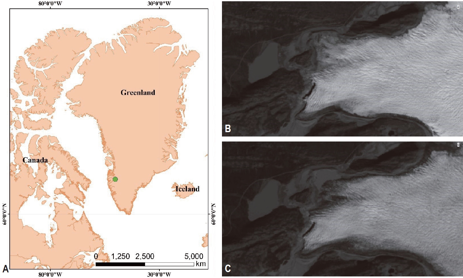
- 현장조사는 그린란드 남서부에 위치한 캉가루수악(Kangerlussuaq) 지역을 중심으로 약 북서방향 25 km 떨어진 러셀(Russell)빙하 말단부를 대상으로 수행되었다(Fig. 1). 러셀빙하는 캉가루수악 인근 빙하 중에서 접근이 가장 용이한 빙하에 해당하며, 다양한 과학분야에서 많은 연구가 시도된 바 있다(Lamsters et al., 2020; Morlighem et al., 2013; Tsai et al., 2019). 특히 빙하 말단부를 따라 인공위성 시계열 광학영상 관측 내에서 후퇴의 진행 양상이 확인되며, 다년간 기온 변화에 따른 지형적 변이의 영향이 지속될 수 있는 유력지역으로 판단된다(Fig. 1).
- 2.2 라이다 sUAV 자료 획득 및 처리
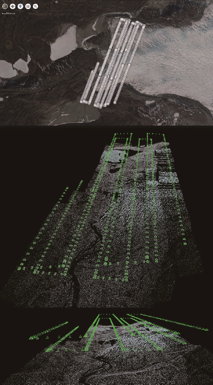
- DSM 구축을 위해 라이다 센서를 탑재한 sUAV를 활용하여 2022년 6월 24일과 25일 눈과 비가 없는 맑은 현장에서 약 100-200 m 고도 환경의 비행을 수행하였다. 회전익기체인 DJI Matrice 300 (M300)에 Zenmuse L1 라이다 센서를 장착하여 활용하였다. 본 연구에서 활용한 기체 및 센서 정보는 Table 1에 정리되었으며, 비행경로는 Fig. 2와 같다.
- 라이다 자료의 경우 비행시 수 cm급의 수직위치정확도를 제공하는 고성능 DJI D-RTK2 (Real Time Kinetic) GNSS 수신기를 베이스 스테이션으로 활용하여 자료를 취득하였다. 2일간 획득한 자료는 DJI Terra 소프트웨어를 활용하여 일괄 처리되었다. 지표에서 반사되어 획득된 레이저 포인트 측정 자료를 기반으로 3차원 Point Cloud를 구축하였으며, las 형태의 점군 데이터셋으로 출력하였다. 자료는 EGM96 지오이드고를 기반으로 후처리되었으며, WGS84 UTM zone 22N에 투영되었다. 포인트 클라우드 데이터셋 구축시 점군 밀도를 샘플 간 5 cm 간격으로 균일화하여 산출하였다. 생성한 포인트클라우드 데이터셋(.las)은 Binning 기법을 기반으로 지표를 구현하여 DSM (Raster)을 구축하였으며, 과거 인공위성 레이더 고도계 영상 자료(ArcticDEM, 2018년 7월 제작) 기반의 DEM 자료를 활용하여 전후 지형 분포 변이 관찰을 수행하였다. 비교를 위해 DSM은 2 m 샘플 간격(cell size)으로 재배열되었다.
2. 본론
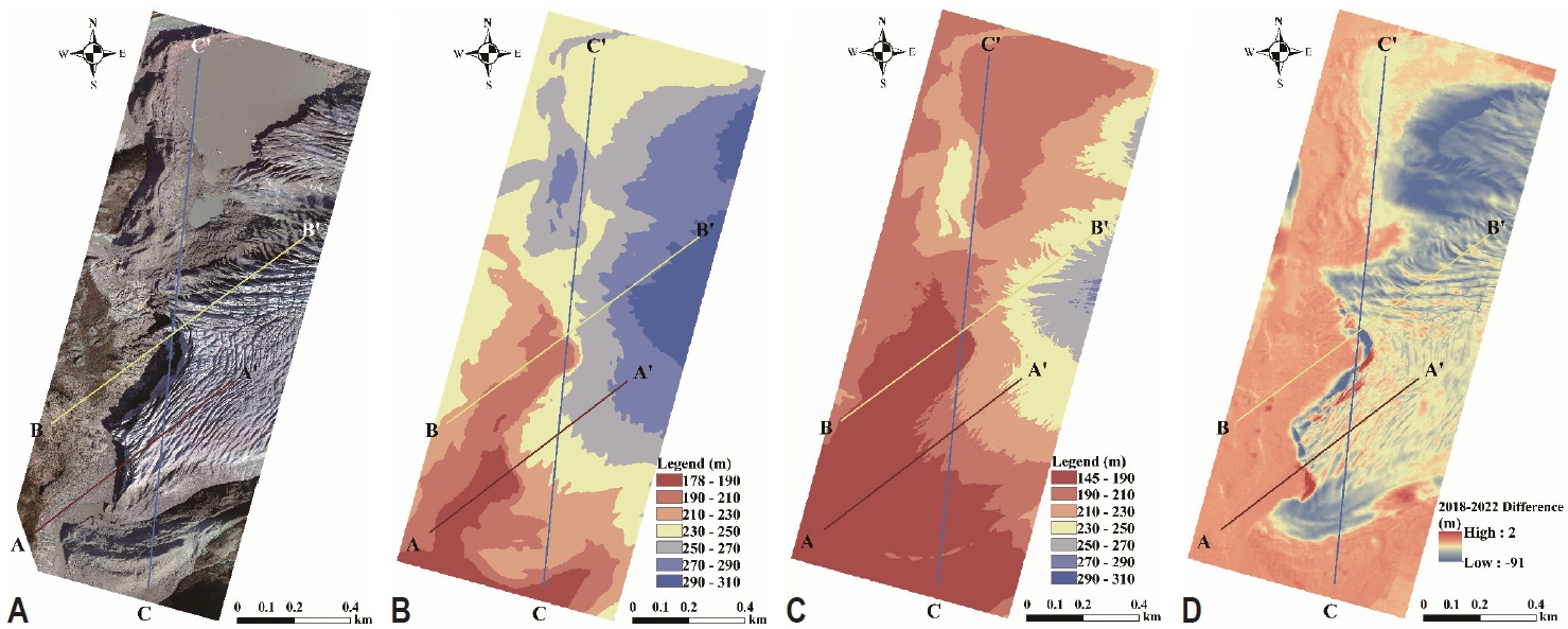
- 연구지역 라이다 기반 DSM 구축 결과 2022년 6월 기준의 고도분포가 과거 2018년 7월 기준 고도분포와 비교하여 연구지역 전반적으로 낮아진 경향의 고도분포를 보여준다(Fig. 3B, C). Fig. 3B와 Fig. 3C 모두 남서 방향에서 북동 방향으로 진행되며 분포하고 있는 빙하 부분에서 고도가 상승하는 패턴의 일치성을 보이고 있으며, 과거에 비해 북쪽 호수가 위치한 고도분포의 면적이 다소 늘어난 분포를 보인다(Fig. 3A-C). 전후 지형 고도 차이를 지시하는 주제도를 기반으로 최대 약 90 m의 감소 변이가 발생한 것을 정량적으로 확인할 수 있었으며, 지역적으로 가장 큰 고도 차이를 보이는 곳은 연구지역 북쪽, 남쪽에 위치한 빙하 말단 부분 및 중심부를 따라 남서방향으로 얇고 길게 늘어진 빙벽부에 해당한다(Fig. 3D). A-A’, B-B’, C-C’ 단면선을 따라 단면 고도분포를 살펴본 결과 공통적으로 2018년 대비 2022년 전반적 고도가 낮게 분포하는 것을 확인할 수 있었으며, 단면선의 진행 방향에 따라 빙하부에서 상승되는 고도 및 빙하 표면 크레바스의 모습을 확인할 수 있다(Fig. 4). 전후 지형 차이를 기반으로 한 단면선 분포를 통해 빙하 표면의 이동에 따라 크레바스 영향으로부터 기인한 편차가 큰 변이 분포가 나타나는 것을 확인할 수 있으며, 특히 단면선 C와 B가 교차하는 빙벽부근 위치에서 극단적인 변이가 발생한 것을 확인할 수 있다(Fig. 4).
3. 결과
- 본 연구에서는 라이다 센서 기반 sUAV 기반으로 획득한 자료를 활용하여, 그린란드 러셀빙하의 지형 변이를 모니터링하는 데 활용할 수 있는 데이터셋을 구축하고, 활용 가능성에 대해 평가하였다. 구축한 정밀 지형 데이터셋 DSM은 전반적으로 과거 자료와 비교하여 연구지역 내에서 합리적인 고도분포 패턴을 나타냈으며, 과거 2018년 대비 2022년 지형의 감소 변이에 관련된 정량화 정보를 제공하였다. 인공위성 영상에서 확인된 바와 대응적으로 연구지역 북쪽에서의 급격한 빙하선 후퇴 및 감소 패턴을 감지하는 데 매우 효과적으로 활용되었으며, 빙하 표면 크레바스의 변이 특성 확인에 있어서도 유용하게 활용될 수 있을 것으로 판단된다. 특히 빙하의 최말단부에 위치하는 빙벽은 상부의 빙하가 쏟아져 내리다 해당 위치에서 붕괴하는 지역적 특성을 가지고 있으며, 붕괴로 인한 급격한 지형 변이의 모습을 확인하는 데 효과적으로 활용되었다. 하지만 GNSS 기반의 베이스스테이션을 기준으로 작성된 무인기 자료에 해당함으로, 수직 오차에 대한 정밀 측량을 통해 보정 혹은 오차의 정도가 추가되어야 할 것으로 사료된다. 향후 지속적으로 sUAV 기반의 정밀 지형 데이터셋을 빙하 미세 변이 관측 모니터링을 위해 구축한다면, 빙하 미세 요인들의 물리적인 이동 패턴에 대한 정량화뿐만 아니라 기후 요인 변화의 편차에 따라 빙하 말단부 물리적 환경의 민감 반응성을 산정하는 데 유용하게 이용될 수 있을 것으로 기대된다.
4. 결론 및 토의
-
Conflict of Interest
Hyun-Cheol Kim has been an Editorial Board of GEO DATA; however, he was not involved in the peer reviewer selection, evaluation, or decision process of this paper. Otherwise, no other potential conflicts of interest relevant to this paper were reported.
-
Funding Information
This research was supported by ‘the International Research & Development Program of the National Research Foundation of Korea (NRF) funded by the Ministry of Science and ICT (PN22070)’ and ‘Korea Polar Research Institute (PE23040)’.
Notes

- Jeong Y, Yu J, Wang L, Shin H, Koh SM, Park G (2018) Cost-effective reflectance calibration method for small UAV images. Int J Remote Sens 39(21):7225–7250Article
- Jouvet G, Weidmann Y, Seguinot J, et al (2017) Initiation of a major calving event on the Bowdoin glacier captured by UAV photogrammetry. Cryosphere 11(2):911–921Article
- Jouvet G, Weidmann Y, Van Dongen E, Lüthi MP, Vieli A, Ryan JC (2019) High-endurance UAV for monitoring calving glaciers: application to the Inglefield Bredning and Eqip Sermia, Greenland. Front Earth Sci 7:206Article
- King MD, Howat IM, Candela SG, et al (2020) Dynamic ice loss from the Greenland ice sheet driven by sustained glacier retreat. Commun Earth Environ 1(1):1ArticlePDF
- Lamsters K, Karušs J, Krievāns M, Ješkins J (2020) High-resolution surface and BED topography mapping of Russell glacier (SW Greenland) using UAV and GPR. ISPRS Ann Photogramm Remote Sens Spat Inf Sci 2:757–763Article
- Morlighem M, Rignot E, Mouginot J, et al (2013) High-resolution bed topography mapping of Russell glacier, Greenland, inferred from Operation IceBridge data. J Glaciol 59(218):1015–1023Article
- Mottram R, Simonsen SB, Høyer Svendsen S, et al (2019) An integrated view of Greenland ice sheet mass changes based on models and satellite observations. Remote Sens 11(12):1407Article
- Mouginot J, Rignot E, Bjørk AA, et al (2019) Forty-six years of Greenland ice sheet mass balance from 1972 to 2018. Proc Natl Acad Sci 116(19):9239–9244ArticlePubMedPMC
- Rossini M, Di Mauro B, Garzonio R, et al (2018) Rapid melting dynamics of an alpine glacier with repeated UAV photogrammetry. Geomorphology 304:159–172Article
- Ryan JC, Hubbard AL, Box JE, et al (2015) UAV photogrammetry and structure from motion to assess calving dynamics at Store glacier, a large outlet draining the Greenland ice sheet. Cryosphere 9(1):1–11Article
- Sasgen I, Wouters B, Gardner AS, et al (2020) Return to rapid ice loss in Greenland and record loss in 2019 detected by the GRACE-FO satellites. Commun Earth Environ 1(1):1–8ArticlePDF
- Śledź S, Ewertowski MW, Piekarczyk J (2021) Applications of unmanned aerial vehicle (UAV) surveys and structure from motion photogrammetry in glacial and periglacial geomorphology. Geomorphology 378:107620Article
- Tomczyk AM, Ewertowski MW (2020) UAV-based remote sensing of immediate changes in geomorphology following a glacial lake outburst flood at the Zackenberg river, northeast Greenland. J Maps 16(1):86–100Article
- Tsai YLS, Lin SY, Kim JR, Choi Y (2019) Analysis of the seasonal velocity difference of the Greenland Russell glacier using multi-sensor data. Terr Atmos Ocean Sci 30(4):541–562Article
References
Appendix
Figure & Data
References
Citations
 PubReader
 ePub Link
 Cite
Cite


#816, 8-13, Gwangpyeong-ro 56-gil, Gangnam-gu, 06367 Seoul, South Korea
Tel: +82-2-6677-5682 E-mail: geodata@gaidas.org
Corporate registration number: 780-82-00418
