Articles
- Page Path
- HOME > GEO DATA > Volume 4(4); 2022 > Article
-
Article
Space Science
다목적실용위성 5호 영상 데이터 제공 및 품질관리 - 양도철*, 정호령, 서두천
- Kompsat-5 Image Data Provision and Quality Management
- Dochul Ynag*, Horyung Jeong, Doochun Seo
-
GEO DATA 2022;4(4):13-19.
DOI: https://doi.org/10.22761/DJ2022.4.4.002
Published online: December 31, 2022
한국항공우주연구원, 지상국기술연구부, 대전 34133, 대한민국
Satellite Ground Station R&D Division, Korea Aerospace Research Institute, Daejeon 34133, Republic of Korea
- *Corresponding author: dcyang@kari.re.kr
• Received: November 28, 2022 • Revised: December 1, 2022 • Accepted: December 7, 2022
Copyright © 2022 GeoAI Data Society
This is an Open Access article distributed under the terms of the Creative Commons Attribution Non-Commercial License (http://creativecommons.org/licenses/by-nc/3.0/) which permits unrestricted non-commercial use, distribution, and reproduction in any medium, provided the original work is properly cited.
- 552 Views
- 41 Download
요약문
- 한국항공우주연구원에서는 사용자에게 신뢰성 있는 다목적실용위성 5호(KOMPSAT-5, K5) SAR 영상제품을 제공하기 위해 지속적인 품질관리를 수행하고 있다. 본 논문에서는 다목적실용위성 5호 위성 및 운영, 자료 처리, 품질관리, 데이터 제공에 대하여 기술하였다. 다목적실용위성 5호 위성의 영상관점에서의 운영 및 영상모드 특성에 대해서 기술하였고 사용자에게 제공하는 영상제품의 분류 및 제품의 특성에 대해서 설명하였다. 또한 SAR 영상의 품질관리를 위해 영상 데이터 획득, 품질인자 측정 및 결과에 대해서 기술하였다. 끝으로 지속적인 품질관리를 통하여 품질이 확인된 영상제품을 사용자에게 신속하게 제공하기 위해 아리랑 시스템을 통한 다목적실용위성 검색 및 주문 방법에 대해서도 설명하고 있다. 다목적실용위성 영상제품은 아리랑 위성 검색 및 주문 시스템(https://ksatdb.kari.re.kr/arirang/)에서 검색 및 주문 가능하다.
Abstract
- The Korea Aerospace Research Institute is conducting continuous quality management to provide reliable Kompsat-5 SAR image products to users. In this paper, the Kompsat-5 satellite operation, data processing, quality management, and data provision were described. The operation and image mode characteristics of the Kompsat-5 satellite from the image point of view were described, and the classification and characteristics of image products provided to users were explained. In addition, image data acquisition, quality index measurement, and its results are described for quality management of SAR images. Finally, it explains how to search for and order Kompsat image product through the ARIRANG system to quickly provide users with image products whose quality has been confirmed through quality management. Kompsat product can be searched and ordered from the ARIRANG Satellite Search and Order System (https://ksatdb.kari.re.kr/arirang/).
- 다목적실용위성 5호는 국내 최초의 SAR 위성으로 지리, 해양, 육지, 재난, 환경 활용을 목적으로 고해상도 SAR 영상을 제공하기 위해 2013년 8월에 발사한 이후 설계수명 5년을 넘어서 현재까지 안정적으로 운영되고 있다. 다목적실용위성 5호의 영상은 고해상도 SAR 영상의 특성을 이용한 표적 탐지, 해양 감시, 홍수지역 파악, 산불 모니터링, 가뭄지수 파악, 지표 변위 모니터링 등 다양한 분야에서 활용되고 있다. 사용자의 폭넓은 활용 요구에 부응하기 위해 해상도 및 영상의 영역을 다양화하여 7개의 영상 모드로 운영하고 있고 포함하는 데이터 정보 및 형식을 체계적으로 분류하여 다양한 계층의 영상제품을 제공하고 있다. 또한, 사용자에게 고품질의 SAR 영상제품을 제공하기 위해 품질관리 체계를 구축하여 주요 품질인자에 대하여 지속적인 품질 모니터링을 수행하고 있다. 품질이 검증된 영상제품을 아리랑 위성 검색 및 주문 시스템을 통하여 제공하고 있다.
1. 서론
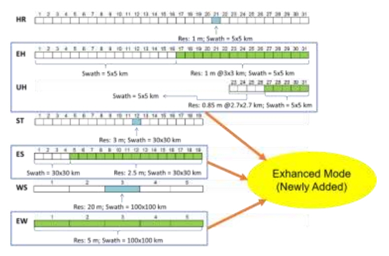
- 다목적실용위성 5호는 고도 550km의 태양동기 궤도로 한반도를 새벽 6시에 지나가는 dawn-dusk 궤도로 운영된다. 현재는 SAR Interferometry(InSAR) 활용을 위하여 28일의 반복 궤도를 유지하도록 운영되고 있으며 지상 궤적(Ground Track)을 1km 내에서 반복적으로 지나가도록 지속적인 궤도 유지를 수행하고 있다. 고해상도 SAR 영상 제공을 위해 전기적인 빔조향이 가능한 X 밴드 SAR 탑재체인 Corea SAR Instrument(COSI)를 운영하고 있으며 지상에 영상데이터를 전송하기 위한 X 밴드 안테나와 지상국과의 통신을 위한 S 밴드 안테나를 구비하고 있다. 발사 초기에는 해상도 1m의 고해상도(High Resolution, HR) 모드, 해상도 3m의 표준(Standard, ST) 모드, 해상도 20m의 광역(Wide Swath, WS) 모드의 3개의 영상 모드로 운영되었지만 2015년에 4개의 해상도가 개선된 Enhanced 모드인 Enhanced HR(EH), Ultra-HR(UH), Enhanced ST(ES), Enhanced WS(EW)를 추가하여 현재 총 7개의 모드로 운영하고 있다. Fig. 1은 다목적실용위성 5호 SAR 영상에 대한 모드 및 빔 별 해상도와 영상폭을 가시적으로 보여주고 있다.
2. 위성 및 운영
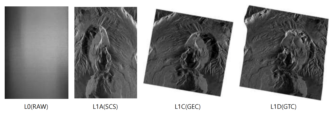
- 다목적실용위성 5호의 영상제품은 자료 처리 레벨 및 포함하는 데이터의 정보에 따라 L0, L1A, L1C, L1D의 4개의 레벨 제품으로 구분할 수 있다. L0 제품은 SAR 탐재체에서 얻어진 에코 형태의 시그널 데이터로 레이더 펄스 순으로 얻어진 복소수 형태의 데이터이다. 이 제품은 노이즈 및 내부 검보정 신호 데이터를 포함하고 있다. L1A 데이터는 L0 데이터를 영상의 Range 및 Azimuth 방향으로 압축 신호 처리하여 영상화한 제품으로 복소수 데이터로 구성되며 Range-Doppler 좌표계에 기초를 두고 있다. 위상(Phase) 데이터를 이용하여 레이더 간섭기법 등의 활용이 가능하다. L1C 데이터는 L1A 영상에서 영상의 세기(Amplitude) 정보만을 추출하여 지구 타원체 모델에 투영한 데이터로 지표 표고모델이 없는 상태에서 지형의 기복이 심한 지역의 즉각적인 분석 및 연구에 활용도가 높다. 마직막으로, L1D 데이터는 영상의 세기 정보를 지구 표면에 투영한 데이터로 지구상의 정확한 지리정보를 필요로 하는 활용에 유용하게 사용될 수 있다. 각각의 레벨 제품은 데이터의 표현 방식 (정수 또는 실수 등)이나 신호처리 과정에서 가중 함수의 적용 여부 또는 사용하는 좌표계의 종류 등에 따라 더욱 세부적으로 구분된다. Table. 1은 다목적실용위성 5호의 대표 표준 제품 및 특성에 대해서 간략하게 기술하고 있다. Fig. 2는 처리 레벨에 따른 표준 제품 예를 가시적으로 보여주고 있다.
3. 자료처리
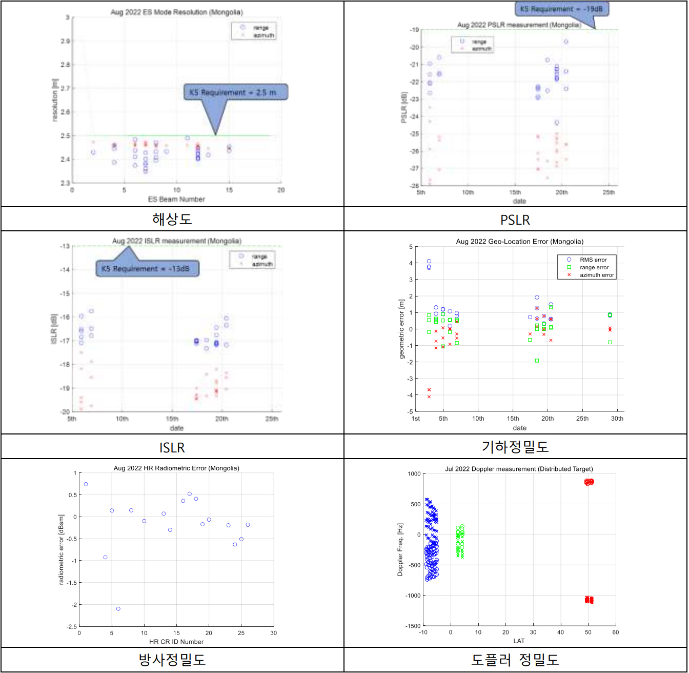
- 한국항공우주연구원에서는 신뢰성 높은 다목적실용위성 5호 SAR 영상제품의 제공을 위해 지속적인 품질관리를 수행하고 있다. 몽골 검보정 사이트에 설치되어 있는 51기의 코너 리플렉터를 포함하는 전세계 점표적과 아마존 열대림 사이트를 포함하는 위도 별 분포표적을 위성 패스마다 주기적으로 촬영하여 SAR 영상 데이터를 수집 관리하고 있고 이 영상을 이용하여 영상의 품질을 지속적으로 관리하고 있다. 몽골, 독일 DLR, 미국 로사몬드, 아르헨티나, 이탈리아의 검보정 사이트에 설치되어 있는 코너 리플렉터를 촬영한 영상에서 IRF(Impulse Response Function)를 측정하여 SAR 영상의 선명도 및 영상처리 성능관련 주요 품질인자인 해상도, PSLR(Peak to Side-Lobe Ratio), ISLR(Integrated Side-Lobe Ratio)을 측정하고 있고 기하정밀도 및 방사정밀도도 지속적으로 모니터링하고 있다. 아마존 열대림, 그린란드, 중국, 아프리카, 뉴기니, 시베리아, 남극, 북극 등의 분포표적을 이용하여 위도에 따른 도플러 주파수 정밀도를 주기적으로 관측하고 있고 추가적으로, 아마존 열대림의 레이더 방사상 균일한 지역을 선별하여 절대방사보정의 결과물인 σ0 지도를 생성하여 값의 추이를 모니터링하고 있다. Fig. 3은 2022년 7-8월에 몽골 코너 리플렉터와 아마존 열대림을 촬영한 K5 SAR 영상으로부터 측정한 품질인자 결과 중 해상도, PSLR, ISLR, 기하 정밀도, 방사 정밀도, 도플러 주파수 정밀도 결과를 도시하여 보여주고 있다. 일부 기하 정밀도가 크게 측정된 데이터는 영상 촬영 당시 기상악화 등에 의한 현상으로 날씨가 맑은 날에는 정상적인 수치로 회복하는 것을 확인하였고 방사정밀도가 벗어나는 경우는 기상악화와 더불어 코너 리플렉터에 쌓인 먼지 및 쓰레기 등으로 인하여 레이더 단면적(Radar Cross Section, RCS)이 저하되는 경우와 사람 및 동물 등에 의하여 코너 리플렉터의 지향이 틀어져서 생기는 경우 등으로 주기적으로 수행하고 있는 청소 및 유지보수 활동 후에는 정상적인 수치로 복귀함을 확인하였다.
- Table. 2는 2022년 8월 품질인자 측정 결과 중 기하정밀도와 방사정밀도를 보여주고 있다.
4. 품질관리
- 다목적실용위성 5호 제품은 HDF 및 GeoTIFF 형태로 아리랑 위성 검색 및 주문 시스템(https://ksatdb.kari.re.kr/arirang/)에서 검색 및 주문 가능하다. 아리랑 시스템에서 원하는 영상의 AOI, 촬영시기, 위성 조건, 운량 등 검색조건을 입력하여 주문이 가능하며 시스템에 이미 저장되어 있는 영상의 주문은 AO(Archive Order) 형태로 진행하고 신규촬영 주문의 경우는 NTO(New Task Order) 형태로 진행하면 된다. 또한, 사용자 그룹으로 등록된 기관을 대상으로 영상 공공배포가 가능하므로 공공배포를 원하는 기관은 사용자 가입신청을 이용하면 된다. 자세한 데이터 검색 및 주문 절차는 아리랑 주문 시스템의 매뉴얼 및 동영상을 참조하면 된다. Fig. 4는 아리랑 위성 검색 및 주문 시스템의 영상 검색 화면을 보여주고 있다.
5. 데이터 제공
- 본 논문에서는 다목적실용위성 5호 위성과 영상 운영, 자료처리, 품질관리, 데이터 제공에 대해서 기술하였다. 지속적인 품질관리를 통해 제공되는 다양한 다목적실용위성 5호 SAR 제품의 특성을 이해하고 데이터 검색 및 주문 방식을 활용하여 데이터를 신속 정확히 사용하면 5호 영상의 활용도가 더욱더 높아질 것으로 기대한다.
6. 결론
-
Acknowledgements
- 본 연구는 한국항공우주연구원의 위성정보활용사업(FR22H00)을 통해 수행되었습니다.
Table 1.Kompsat-5 level product and characteristics
Table 2.K5 Geometric and Radiometric Accuracies in August 2022
| 품질 인자 | ES | EH & UH |
|---|---|---|
| 기하 정밀도 (CE90) | 2.623 m | 2.981 m |
| 방사 정밀도 (1σ) | 0.380 dBsm | 0.164 dBsm |
- Yang D., Jeong H. (2018) Verification of Kompsat-5 Sigma Naught Equation. Korean Journal of Remote Sensing 34(6_3):1457–1468. https://doi.org/10.7780/KJRS.2018.34.6.3.11Article
- Lee T., Yang D. (2021) Back-scattering Characteristic Analysis for SAR Calibration Site. Korean Journal of Remote Sensing 37(2):305–319. https://doi.org/10.7780/KJRS.2021.37.2.10Article
- Jang J.-C., Park K.-A., Yang D. (2018) Validation of Sea Surface Wind Estimated from KOMPSAT-5 Backscattering Coefficient Data. Korean Journal of Remote Sensing 34(6_3):1383–1398. https://doi.org/10.7780/KJRS.2018.34.6.3.6Article
- Jang J.-C., Park K.-A., Yang D., Lee S.-G. (2019) Improvement of KOMPSAT-5 Sea Surface Wind with Correction Equation Retrieval and Application of Backscattering Coefficient. Korean Journal of Remote Sensing 35(6_4):1373–1389. https://doi.org/10.7780/KJRS.2019.35.6.4.7Article
참고문헌
Appendix
| Sort | Field | Subcategory#1 | Subcategory#2 |
|---|---|---|---|
| Essential | *Title | Kompsat-5 SAR Image Product Example | |
| K5_20190222145029_000000_30222_D_HR22_HH_GTC_B_L1D | |||
| *DOI name | 10.22761/DATA2022.4.4.002 | ||
| *Category | geoscientificInformation | ||
| Abstract | The K5 operates in seven measurement modes: three basic modes − Standard (ST), High Resolution (HR), Wide Swath Mode (WS) and four enhanced modes − Enhanced High Resolution (EH), Ultra High Resolution (UH), Enhanced Standard (ES), Enhanced Wide Swath (EW). K5 product can be classified according to the following basic features: 1) instrument mode, 2) processing level 3) data information (e.g. weighting, projection). K5 Product Level is classified as follows: 1) L0 (RAW), 2) L1A (SCS), 3) L1C (GEC), 4) L1D (GTC). | ||
| The product is HR mode data measured on February 22, 2019 with descending orbit. The polarization of the product is HH and the product is projected on Earth surface considering topography height and recorded with 16bit integer (GTC_B product). The product is available on-line at https://ksatdb.kari.re.kr/arirang/. | |||
| *Temporal Coverage | February 22, 2019 | ||
| *Spatial Coverage | Latitude 13.345 ° N ~ 13.400 ° N, | ||
| Longitude: 41.669 ° E ~ 41.7217 ° E | |||
| *Personnel | Registrant (Dochul Yang)/Owner (Korea Aerospace Research Institute) | ||
| dcyang@kari.re.kr | |||
| *CC License | |||
| Optional | *Project | Satellite Information Application Project of KARI | FR22H00 |
| *Instrument | Kompsat-5 SAR (COSI) | Image Mode: HR, EH, UH, ST, ES, WS, EW | |
| Level Product: L0, L1A, L1C, L1D |
Figure & Data
References
Citations
Citations to this article as recorded by 


 GAIDAS


 PubReader
 ePub Link
 Cite
Cite


