
Previous issues
- Page Path
- HOME > Articles and Issues > Previous issues
- Volume 5(2); June 2023
-


Original Papers
- Quantitative Study of Butterfly Diversity in Wando Quercus acuta Forest Over 5 Years (2017-2021)
- Sanghun Lee, Na-Hyun Ahn
- GEO DATA. 2023;5(2):55-59. Published online June 20, 2023
- DOI: https://doi.org/10.22761/GD.2023.0010
- 2,505 View
- 400 Download
-
 Abstract
 PDF
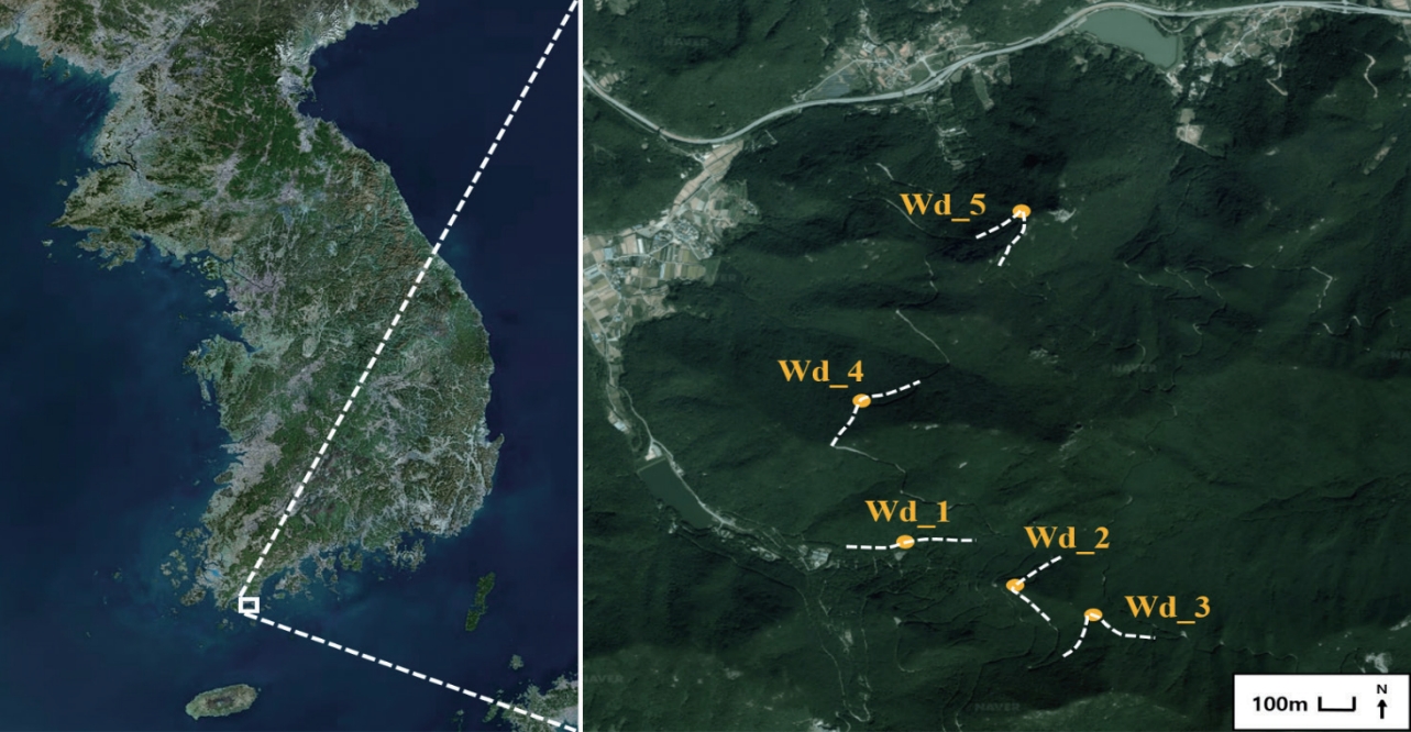
PDF - This study presents the long-term quantitative data on butterflies in Wando Arboretum, which represents the only warm-temperate forest located in the southernmost part of South Korea. This arboretum has significant academic value as approximately 770 species of rare woody plants or herbs, such as the Japanese evergreen oak (Quercus acuta), found in warm temperate zones grow under natural conditions here. In this project, the butterflies in this region were studied due to their sensitivity to temperature changes. The study was conducted from March-April to October-November over 5 years (2017-2021) in the region dominated by Japanese evergreen oak. We found 1,743 individuals of 47 butterfly species belonging to five families. The acquired butterfly data could serve as a reference for the further development of a network-oriented database for assessing temporal climate changes.
- Distribution Characteristics of the Clithon retropictus in the Estuarine Wetland
- Yeounsu Chu, Pyoungbeom Kim
- GEO DATA. 2023;5(2):60-65. Published online June 12, 2023
- DOI: https://doi.org/10.22761/GD.2023.0011

- 705 View
- 75 Download
-
Abstract
PDF
 Supplementary Material
 - This study analyzed the distribution characteristics of Clithon retropictus (C. retropictus), an endangered species, using data from the benthic macroinvertebrate survey on estuarine ecosystems conducted in 2021-2022. A total of 5,906 individuals of C. retropictus were identified in 60 estuarine wetlands located along the eastern coast, southern coast, and Jeju area. It was confirmed to be a dominant species in certain estuarine wetlands such as Obangcheon, Gohyeoncheon, and Osucheon. The southern coast of Gyeongsangnam-do was identified as a major distribution area, indicating the need for systematic conservation and management of C. retropictus in this region. Furthermore, as a basic survey of benthic macroinvertebrates is currently being conducted in Jeolla-do, it is expected that nationwide distribution data for C. retropictus will be obtained.
- Dataset on the Distribution of Ecosystem-Disturbing Plants in the Republic of Korea
- Man-Seok Shin, Yu Jin Hong, Sanghun Lee
- GEO DATA. 2023;5(2):66-76. Published online June 27, 2023
- DOI: https://doi.org/10.22761/GD.2023.0009

- 1,027 View
- 97 Download
-
Abstract
PDF
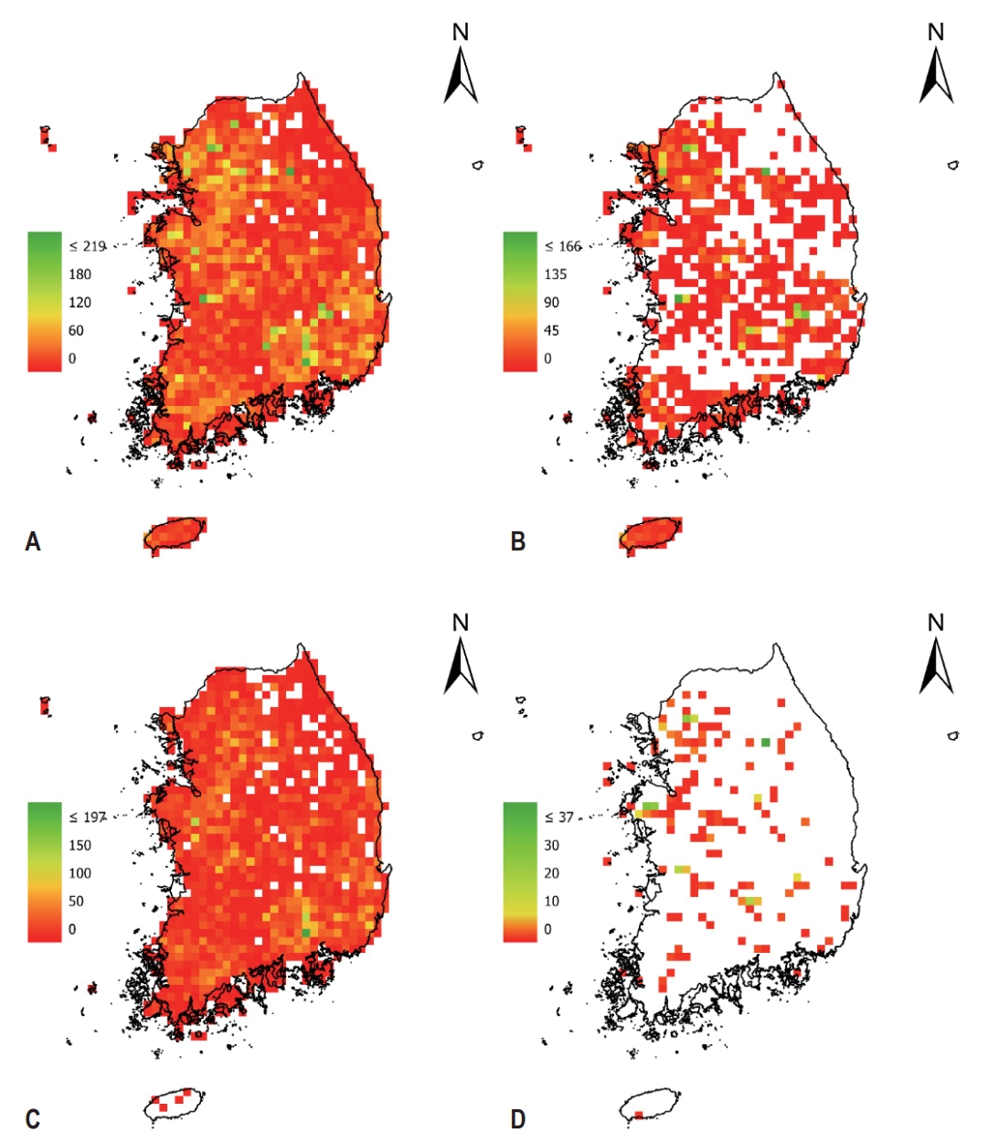
- In this study, we presented distribution data for 16 plant species designated as ecosystem-disturbing species by the Ministry of Environment of the Republic of Korea. These data include location information for the ecosystem-disturbing plants from four survey projects (Monitoring of invasive alien species designated by the wildlife protection act, Nationwide survey of non-native species in Korea, The 3rd and 4th national ecosystem survey) conducted by two agencies (National Institute of Ecology and National Institute of Environmental Research) between 2014 and 2021. Additionally, the data includes habitat environmental characteristics and administrative district information on the survey sites of the ecosystem-disturbing plants. These data have a high potential for utilization as basic information for natural environmental policies and related research by identifying the habitat characteristics of invasive alien species.
- The Integrated Dataset for Occurrence of Odonata Species in South Korea
- Sungsoo Yoon
- GEO DATA. 2023;5(2):77-86. Published online June 30, 2023
- DOI: https://doi.org/10.22761/GD.2023.0013
- 712 View
- 33 Download
-
Abstract
PDFSupplementary Material
- This study presents an integrated dataset comprising occurrence records for 102 Odonata species in South Korea. The occurrence information of the Odonata species was collected from 10 independent field survey-based datasets, spanning the period from 2014 to 2023 and provided by three agencies: National Institute of Ecology, National Institute of Environmental Research, and Global Biodiversity Information Facility (GBIF). In addition to occurrence data, the dataset includes information on the survey year, IUCN (International Union for Conservation of Nature) Red List classification, satellite-derived spectral indices and bioclimatic variables to provide valuable insights into the survey sites and habitats of Odonata species. By integrating diverse dataset, this comprehensive Odonata dataset can contribute to the validation of habitat-related traits, enhances the national checklist information, and facilitates the identification of rarity and potential habitats for Odonata species in South Korea. The integrated Odonata dataset serves as a valuable resource for ongoing Odonata research and conservation efforts in the study area.
- Investigation of Cicada Density in Urban Park
- Jae-Yeon Kang, Yong-Su Kwon
- GEO DATA. 2023;5(2):87-91. Published online June 30, 2023
- DOI: https://doi.org/10.22761/GD.2023.0017

- 601 View
- 26 Download
-
Abstract
PDF
- In this study, we investigated the occurrence patterns and densities of cicadas in 18 urban parks in Seoul, Korea. Considering the ecological characteristics of cicadas that occured only in summer, the temporal changes of cicadas were investigated every week from June to September in 2017. Cicadas densities were measured using the final instar exuviae of cicada, which showed distinct morphological differences between species. A total of 7,369 cicada exuviae of six species were collected, and the dominant species in urban park were Hyalessa fuscata (44.8%) and Cryptotympana atrata (41.7%). There was no clear difference in the pattern of occurrence by species, but it occurred most frequently around August when the rainy season ended.
- Comparative Study of Machine Learning and Deep Learning Models Applied to Data Preprocessing Methods for Dam Inflow Prediction
- Youngsik Jo, Kwansue Jung
- GEO DATA. 2023;5(2):92-102. Published online June 30, 2023
- DOI: https://doi.org/10.22761/GD.2023.0016
- 571 View
- 44 Download
-
Abstract
PDF
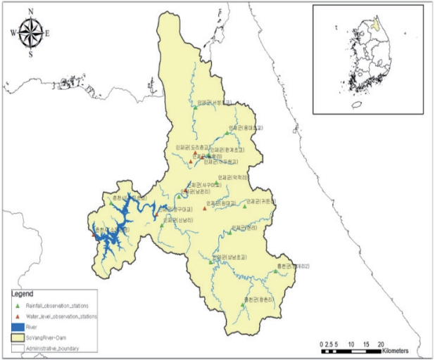
- In this study, we employed representative machine learning (ML) and deep learning (DL) models previously utilized in the fields of rainfall and runoff analysis in the water resources sector. We not only performed hyperparameter tuning of the models but also considered the characteristics of the model and the combination and preprocessing (such as lag-time and moving average) of meteorological and hydrological data. We then compared and evaluated the performance of the models according to various scenarios of data characteristics and ML & DL model combinations for predicting daily water inflow. To accomplish this, we utilized meteorological and hydrological data collected from 1974 to 2021 in the Soyang River Dam Basin to examine 1) precipitation, 2) inflow, and 3) meteorological data as primary independent variables. We then employed a total of 36 scenario combinations as input data for ML & DL, applying a) lag-time, b) moving average, and c) component separation conditions for inflow. To identify the most suitable data combination characteristics and ML & DL models for predicting daily inflow, we compared and evaluated 10 different ML & DL models: 1) Linear Regression, 2) Lasso, 3) Ridge, 4) Support Vector Regression, 5) Random Forest (RF), 6) Light Gradient Boosting Model, 7) XGBoost for ML, and 8) Long Short-Term Memory (LSTM) models, 9) Temporal Convolutional Network (TCN), and 10) LSTM-TCN for DL.
- The Introduction of Naju Ground Observation Site Measurement Data and Web Service for Validation of Satellite Value-Added Products
- Jong-Sung Ha, Seung-taek Jeong, Hyun-Ok Kim, Sun-Gu Lee, Dae-won Jeong, Jaeil Cho, Seo Ho Shin, Kil-Ja Kim, Dong-Kwan Kim, Jong-Min Yeom
- GEO DATA. 2023;5(2):103-109. Published online June 27, 2023
- DOI: https://doi.org/10.22761/GD.2023.0012

- 515 View
- 33 Download
-
Abstract
PDF
- The Korea Aerospace Research Institute (KARI) has collaborated with Jeollanamdo Agricultural Research & Extension Services and Chonnam National University to establish a ground observation tower for evaluating the value-added products (such as surface reflectance and Normalized Difference Vegetation Index) and improving algorithms of domestic development satellites (Korea Multi-Purpose Satellite-3, 3A and 7). The ground measurement tower, installed at the Jeollanamdo Naju ground observation site (NGOS), constantly observes surface hyperspectral reflectance and atmospheric information, providing the advantage of real-time algorithm validation improvement when satellite acquires images of the site. The NGOS operates hyperspectral radiometer equipment (6 types), meteorological observation equipment (5 types), sky radiometer (1 type), and eddy flux observation equipment (2 types), along with a web service for display and data processing. The ground observation site equipment that is being installed and operated can be utilized in various fields such as carbon circle, agriculture, environment, atmosphere and climate change, in addition to validation of satellite value-added products. This study aims to introduce KARI NGOS for user data sharing and highlight the characteristics of the measured data.
- Long-Term Change and Analysis of the Sedimentary Environment of Dadae Beach Using Unmanned Aerial Vehicles
- Joo Bong Jeong
- GEO DATA. 2023;5(2):110-117. Published online June 30, 2023
- DOI: https://doi.org/10.22761/GD.2023.0018

- 695 View
- 42 Download
-
Abstract
PDF
- Dadae Beach, located at the Nakdong river estuary, has been continuously evolving over the years, and this is the result of complex interactions between natural and artificial factors. In particular, in the case of Dadae Beach, located at the estuary of the Nakdong river estuary, it is located at the boundary between the river and the ocean, and it is an environment in which various deposition mechanisms operate. It is a very difficult research task to analyze the beach evolution mechanism, and a long-term study using precise measurement methods is required. Therefore, in this study, precision unmanned aerial surveys were conducted three times (2015, 2019, and 2021) for 5 years to identify the sedimentary characteristics of Dadae Beach, and the sedimentary environment was analyzed through the analysis of surface sediment texture characteristics. Seasonal waves and winds caused by the East Asian monsoon climate are the main mechanisms for the sedimentation of Dadae Beach, and finegrained sediments are distributed throughout the beach. In addition, the formation of sandbar, which arose rapidly due to artificial influences such as the construction of estuary banks in the past, is a major factor in the evolution of large-scale beaches. This study is meaningful in identifying the mechanism of beach evolution and presenting quantitative analysis results through comparison of precision aerial survey data over a long period of time.
 First
First Prev
Prev


Editorial Office of GEO DATA

#816, 8-13, Gwangpyeong-ro 56-gil, Gangnam-gu, 06367 Seoul, South Korea
Tel: +82-2-6677-5682 E-mail: geodata@gaidas.org
Corporate registration number: 780-82-00418