
Articles
- Page Path
- HOME > GEO DATA > Volume 5(2); 2023 > Article
-
Original Paper
한국의 잠자리목 출현 정보 통합 데이터세트 -
윤성수*

- The Integrated Dataset for Occurrence of Odonata Species in South Korea
-
Sungsoo Yoon*
-
GEO DATA 2023;5(2):77-86.
DOI: https://doi.org/10.22761/GD.2023.0013
Published online: June 30, 2023
전임연구원, 국립생태원 생태정보팀, 충청남도 서천군 마서면 금강로 1210, 33657, 대한민국
Researcher, Ecological Information Team, National Institute of Ecology, 1210 Geumgang-ro, Maseo-myeon, Seocheon-gun, 33657 Chungcheongnamdo, South Korea
- Corresponding Author Sungsoo Yoon Tel: +82-41-950-5645 E-mail: yssfran@nie.re.kr
Copyright © 2023 GeoAI Data Society
This is an Open Access article distributed under the terms of the Creative Commons Attribution Non-Commercial License (http://creativecommons.org/licenses/by-nc/3.0/) which permits unrestricted non-commercial use, distribution, and reproduction in any medium, provided the original work is properly cited.
- 736 Views
- 34 Download
Abstract
- This study presents an integrated dataset comprising occurrence records for 102 Odonata species in South Korea. The occurrence information of the Odonata species was collected from 10 independent field survey-based datasets, spanning the period from 2014 to 2023 and provided by three agencies: National Institute of Ecology, National Institute of Environmental Research, and Global Biodiversity Information Facility (GBIF). In addition to occurrence data, the dataset includes information on the survey year, IUCN (International Union for Conservation of Nature) Red List classification, satellite-derived spectral indices and bioclimatic variables to provide valuable insights into the survey sites and habitats of Odonata species. By integrating diverse dataset, this comprehensive Odonata dataset can contribute to the validation of habitat-related traits, enhances the national checklist information, and facilitates the identification of rarity and potential habitats for Odonata species in South Korea. The integrated Odonata dataset serves as a valuable resource for ongoing Odonata research and conservation efforts in the study area.
- 잠자리목(Odonata) 종들은 담수 및 육상 생태계에서 작은 모기, 나방류들을 섭식하는 포식자로 질병 확산 방지와 농업 해충 제거(Calvão et al., 2018; Miguel et al., 2017)를 통해 인류에게 유익한 생태계서비스를 제공한다. 뿐만 아니라 잠자리목에 속하는 종들은 개구리, 어류, 조류의 먹이가 되어 자연 생태계 먹이그물에서 중요한 지위를 차지하고(Pinto and De Almeida, 2016), 기후 변화 감지와 생태계 건강성을 평가하는 데 중요한 생물학적 지표로 사용될 수 있다(White et al., 2015). 환경부에서 2022년에 발간한 국가생물종목록에는 12과 62속 133종의 잠자리목 종이 기록되어 있으며, 대모잠자리(Libellula angelina), 한국꼬마잠자리(Nannophya koreana), 노란잔산잠자리(Macromia daimoji)가 환경부 지정 멸종위기야생생물 II급으로 지정되어 있다. 특히 멸종위기종의 서식지 특성 규명, 생활사 분석, 개체군 마커 개발 등을 통한 보전과 복원 전략 수립 관련 연구가 다수 수행되었다(Kim et al., 2020; Kim et al., 2022; Yoon et al., 2010). 또한, 대한민국에 분포하는 잠자리목 종들의 체크리스트(Cho, 2021)와 수환경에 따른 잠자리목 군집 분포 연구(Lee et al., 2018)가 수행되었지만, 구체적인 좌표와 서식지 특성을 분석할 수 있는 데이터는 제공하지 않고 있다.
- 본 연구에서 생성한 데이터세트는 국립생태원, 국립환경과학원, Global Biodiversity Information Facility (GBIF)에서 보유하고 있는 조사사업 및 시민과학 자료를 통해 2014년부터 2023년 4월까지 수집된 잠자리목 종들의 위치정보를 포함한다. 또한, 잠자리목이 발견된 각 지점에 해당하는 기후와 토지피복정보 역시 제공한다. 이 연구는 대한민국 잠자리목 종들에 대한 종합적인 보전 및 복원 방안 마련을 위해 잠자리목 종의 다양성, 희귀성, 생태적 지위 등을 분석할 수 있는 데이터를 제공하고자 한다.
1. 서론
- 2.1 데이터 수집
- 환경부 2022년 국가생물종목록(환경부 2022)에 기록된 133종의 잠자리목을 대상으로 국립생태원, 국립환경과학원 및 GBIF가 보유한 현장조사 기반 데이터에서 지점정보(생물종 위치좌표), 조사년도, 생활사 단계, 데이터의 URL(uniform resource locator) 주소, 출처 명칭을 수집하였다. 국립생태원 조사사업으로 수집한 데이터는 국제생태정보종합은행(EcoBank; https://www.nie-ecobank.kr)의 DOI 발행 자료, 데이터 공개 현황, 전국자연환경조사 시민참여 게시판에서 개방 중인 자료를 수집하였다. 하천 및 하구 생물측정망 출현생물종는 위치좌표가 없는 조사지점별 출현정보를 국립환경과학원 물환경정보시스템(https://water.nier.go.kr/)에서 내려받은 뒤 공공데이터포털(https://data.go.kr) 공공데이터 제공신청을 통해 확인된 조사지점별 대표 위치좌표를 결합하여 생성하였다. 마지막으로 GBIF 데이터는 python version 3.9.0의 pygbif 모듈을 통해 GBIF API(application programming interfaces) 서비스를 활용하여 잠자리목의 종의 조사 자료를 추출하였다. EcoBank는 원데이터를 수집한 국립생태원 조사사업의 대상에 따라 육상곤충과 저서성대형무척추동물로 나누어 데이터세트를 개방하고 있으며, 시민참여조사는 육상곤충을 대상으로 데이터 수집이 수행되었다. 따라서 생활사 단계는 육상곤충조사 데이터세트 출처인 경우 “Adult”로, 저서성대형무척추동물조사 데이터세트 출처인 경우에는 “Larva”로 나누어 기록하였다. 국립환경과학원 하천 및 하구 생물측정망 데이터세트 역시 원데이터에 저서성대형무척추동물로 명시되어 있기 때문에 생활사 단계 정보를 “Larva”로 기입하였다. 조사 대상이 명확하지 않은 GBIF 데이터는 원데이터의 ”lifeStage” 필드를 통해 생활사 단계를 판단하였으며, null 값은 “Unknown”으로 기입하였다. 잠자리목 종의 학명은 GBIF (2023), Paulson et al. (2022), Cho (2021)의 자료를 토대로 정명으로 수정되었으며, 정리된 정명을 토대로 IUCN (International Union for Conservation of Nature) 적색목록(https://www.iucnredlist.org/) 분류코드정보를 추가하였다.
- 잠자리목 위치정보를 토대로 생물기후변수 19종, 해발고도, 원격탐사 자료 기반 광학지수(spectral index) 4종 등 총 24종의 환경변수를 추가하였다. 생물기후변수는 연평균 기온, 가장 따뜻한 달의 최고기온 등을 1 km 해상도의 30년 기후 평년으로 계산한 WorldClim (https://worldclim.org/) 자료를 R version 4.1.3의 raster 패키지를 통해 추출하였다. 해발고도는 Google Earth Engine Code Editor(GEEC; https://code.earthengine.google.com)를 통해 Advanced Land Observing Satellite (ALOS; https://www.eorc.jaxa.jp/ALOS/en/dataset/aw3d30/aw3d30_e.htm)에서 제작한 30 m 해상도의 수치표면모델 자료를 수집하였다. 마지막으로 GEEC를 활용하여 2014년에서 2022년 사이의 6월에서 8월 사이 구름, 그림자 및 눈의 효과를 마스킹한 Landsat 8 위성 이미지를 합본(composite)으로 생성하고, Normalized Difference Vegetation Index (NDVI), Normalized Difference Built-up Index (NDBI), Normalized Difference Water Index (NDWI), Bare Soil Index (BSI)를 Landsat 8 이미지 합본의 중간값으로 계산하여 수집하였다.
- 2.2 데이터 수정 및 구축
- 대한민국 잠자리목 통합 데이터는 점 형태의 정보를 Korea 2000/Central Belt 2010 좌표계로 투영하고, gpkg 파일 형식으로 구축되었다. 공간오류를 제거하기 위해 Database of Global Administrative Areas (https://gadm.org)에서 제공하는 polygon 형태의 대한민국 경계 shp 파일과 교차(intersection)가 가능한 데이터만 남겨두었다. 2014년 이후 연간 자료를 확보할 수 있는 Landsat 8 자료를 고려하여 2014년 이전을 대표하는 잠자리목조사 자료는 제거하였다. 또한, 중복 자료를 제거하기 위해, GBIF 데이터는 수집 시 “references” 필드에서 국립생태원 제공 데이터세트를 지칭하는 “NIEK”가 포함된 데이터가 제거되었다. 더불어 추가적인 중복을 방지하기 위하여 조사년도, 위도, 경도, 학명이 일치하는 자료를 제거하고 24종의 환경변수에서 null값이 나오지 않는 자료들만 추출하였다. 데이터 오류 수정과 구축은 R version 4.1.3에서 stats, dplyr, raster, rdgal, sf 패키지를 활용하여 수행하였다. 최종적으로 수집된 데이터세트 필드는 Table 1과 같다.
- 2.3 활용된 잠자리목 데이터세트 개요
- 대한민국 잠자리목 통합 데이터는 10개의 데이터세트로 구성되었으며(Table 2), 국립생태원 출처의 데이터세트가 가장 높은 비중을 차지하고 있다.
- 본 연구에서는 전국자연환경조사, 특정지역 자연환경조사, 내륙습지조사 크게 4개의 조사사업에서 생성된 7개의 데이터 세트를 활용하였다. 가장 큰 비중을 차지하는 「전국자연환경조사」의 조사는 5년을 주기로 전국을 조사하며, 크게 저서성대형무척추동물, 육상곤충 및 시민참여조사로 나뉜다. 먼저 저서성대형무척추동물조사는 환경부에서 제작한 공통 유역도의 850개 소권역을 대표할 수 있는 저서성대형무척추동물상을 조사하기 위해 정수역, 본류, 지류 등의 서식지 유형을 나누고 동일한 규격의 채집장비(예시: 망목 1 mm 이하의 D-frame net)를 활용하여 조사를 수행한다(National Institute of Ecology, 2022b). 육상곤충조사는 전국을 1/25,000 축척으로 나눈 824개 도엽을 대표할 만한 서식지와 식생을 중심으로 조사지역을 선정하여 동절기를 제외하고 쓸어잡기, 채어잡기 등 직접적인 채집과 트랩설치를 병행하여 연간 최소 2회 이상 실시한다(National Institute of Ecology, 2022b). 시민참여조사 데이터는 일반인 조사자가 정량적인 조사 체계 없이 수집된 기회주의적(opportunistic)인 데이터로, 분류군 전문가의 동정을 마친 데이터만 포함하고 있다.
- 「전국내륙습지조사」와 「특정지역 자연환경조사」 전국자연환경조사의 육상곤충 및 저서성대형무척추동물조사와 같은 조사 방법을 통해 환경부지정 습지, 생태경관 우수지역, 백두대간 보호지역, 국립공원 등의 조사 대상지의 대표 서식지를 선정하고 각 조사 대상지의 분류군별 생물상을 대표할 수 있도록 조사를 실시한다. 「전국내륙습지조사」는 전국자연환경조사와 동일하게 5년 단위로 실시하고 있으며, 국가습지인벤토리에 지정된 2,499개 습지 중 4대강별로 설정된 소권역을 대표하는 1,046개의 습지를 지난 2016년에서 2020년까지 조사하였으며(National Institute of Ecology, 2022a), 2021년에는 신규로 발굴된 전국 172개의 습지를 대상으로 생물상조사를 실시하였다. 「특정지역 자연환경조사」는 환경부에서 지정한 무인도서, 백두대간 보호지역, 생태·경관 우수지역 등 8개 특정지역 생태계를 세부 조사사업을 통해 5년에서 10년 주기로 조사를 실시하고 있다(EcoBank, 2023). 본 연구에서는 「백두대간 보호지역 생태계조사」를 대표하는 데이터세트와 「생태·경관보전지역 정밀조사」, 「생태·경관우수지역 발굴조사」, 「전국 해안사구 자연환경조사」, 「전국 무인도서 자연환경조사」, 「독도생태계 정밀조사」, 「특정도서 정밀조사」가 통합된 「특정지역 자연환경조사」 데이터세트를 활용하였다.
- 환경과학원은 물환경보전법 제9조의 3(수생태계 현황조사 및 건강성 평가)과 동법 제24조 2(수생태계 현황조사)에 근거하여 2023년 현재 3년 주기로 전국의 하천(2,795) 및 하구(660)의 수생태계를 조사하고 있다(National Institute of Environmental Research, 2022). 하천 수생태계조사의 경우 2016년 이전에는 전국을 한강, 낙동강 등 주요 수계로 나눈 뒤 총 960여 지점을 연단위로 조사하였으며, 현재는 총 3,016지점 중 221지점을 연단위로 조사 중이다(Chungbuk Research Institute, 2020; National Institute of Environmental Research, 2022). 국립환경과학원 고시 제2019-52호 「수생태계 현황조사 및 건강성 평가 방법 등에 관한 지침」에 따르면 봄(4-5월)과 가을(9-10월)에 선정된 조사지점에서 저서성대형무척추동물을 수집하고 있다.
- GBIF 데이터는 국립생태원 전국자연환경조사 시민참여조사와 같이 기회주의적인 데이터로 크게 2,417개 지점의 iNaturalist (https://www.inaturalist.org) 자료와 16개 지점의 Observation.org (https://observation.org) 자료로 나뉜다. GBIF는 연구 자료 등급의 iNaturalist 데이터만을 수집하기 때문에 데이터 검증을 위한 사진, 위치, 관찰자 및 2/3 이상의 동의를 얻은 종 수준의 동정(identification) 절차 등을 잠자리목 종의 발견지점별로 지정된 URL을 통해 확인할 수 있다. 이와 유사하게 Observation.org 자료도 전문가 및 제공기관의 내부 검증 절차를 마친 잠자리목 종들의 위치정보만 포함되었으며, 지점별 세부정보는 개별 데이터에 주어진 URL 주소를 통해 접근할 수 있다.
2. 본론
2.3.1 국립생태원 조사사업 데이터
2.3.2 환경과학원 하천 및 하구 생물측정망조사
2.3.3 GBIF 데이터
- 본 연구는 잠자리목 102종의 총 27,515개 조사 위치정보를 xlxs 형식으로 구축하였으며(Supplementary Material 1), 10 km 해상도 격자를 설정하였을 때, 평균적으로 약 26개의 위치정보가 발견되었다(Fig. 1A). 특히, 수계 권역별로 설정된 조사지점과 인구가 집중된 한강과 낙동강 인근에서 보다 많은 수의 잠자리목 종들의 지점정보가 수집되었다. 180개 이상의 지점정보를 상회하는 격자들이 시민과학 데이터가 집중적으로 수집된 작은 구역을 포함하고 있는 것을 확인하였다. 성충 잠자리목 데이터는 총 8,219개 지점정보가 수집되었으며, 10 km 해상도 격자별로 약 13개의 위치정보를 확인할 수 있다(Fig. 1B). 유충은 총 18,923개 지점정보가 수집되어 성충의 2배 이상이 수집되었고, 10 km 격자 평균 19개의 위치정보가 확인되었다(Fig. 1C). 수집한 데이터세트 중 다수가 저서성대형무척추동물을 대상으로 수행한 국립생태원과 환경과학원 조사사업을 통해 생성되었기 때문에 위와 같은 차이를 보여주었다. 생활사 단계를 알 수 없는 잠자리목 위치정보는 총 373지점으로, 그 수가 상대적으로 적었으며 모두 GBIF에서 수집된 시민과학 데이터였다(Fig. 1D).
- 2014부터 2019년까지는 연도별 데이터의 총 수가 증가하는 추세였지만, 2020년부터 잠자리목 데이터의 수량은 급격히 감소하였다(Fig. 2). 2014년부터 2021년까지 과(family) 수준 지점정보의 비율은 큰 변동이 없는 것을 보여주었다(Fig. 2A). 국립환경과학원의 하천 수생태계조사는 연도별로 가장 일정한 수량의 잠자리목 데이터를 수집되고 제공하는 것으로 나타났다(Fig. 2B). 수집 가능한 국립생태원과 국립환경과학원 조사사업 기반 데이터가 2014년부터 2019년까지는 비교적 많았으나, 2021년 이후에는 GBIF와 제5차 전국자연환경조사 출처의 시민과학 데이터만 수집되었다. 이에 따라 2022년에는 가장 많은 종수를 차지하는 잠자리과(Libellulidae)의 비율이 크게 상승하고 2023년에는 실잠자리과(Coenagrionidae) 지점정보 1건만이 수집되었다. 잠자리목 종별 평균 약 270개의 지점정보가 수집되었으며, 아시아실잠자리(Ishchnura asiatica), 밀잠자리(Orthetrum albistylum), 등검은실잠자리(Paracercion calamorum) 등 8개 종은 1,000개 이상의 지점정보가 수집되었다(Fig. 3A). 잠자리목 39개 종은 100개 이상의 지점 정보를 보여줬으나, 북한에서 서식한다고 알려진 시골실잠자리(Coenagrion ecornutu), 북방잠자리(Somatochlora alpestris), 청동잠자리(Cordulia aenea), 환경부 지정 멸종 위기종 II급인 한국꼬마잠자리(N. koreana) 등을 포함하여 지점정보가 10개 이하인 종들도 22종에 달하였다(Fig. 3B, 일부 시각화). 잠자리목 환경 및 생물기후 변수 대상으로 D’Agostino 왜도 검정(D’Agostino 1970)을 실시하였을 때 고도(maximumElevationinMeters), NDWI, bio19 등 수계와 관련된 환경변수들은 주로 강한 right-skewness (Skewness >1)를 지닌 데이터 분포를 보여주었고, 평균 온도와 관련된 bio5, bio10, bio8 및 NDVI는 강한 left-skewness (Skewness <-1)를 보여주었다(Fig. 4).
3. 결과
- 본 데이터는 현재 개방 중인 생태조사, 원격탐사 및 기후 모형 데이터세트를 활용하여 잠자리목 102종의 지점정보와 서식지 특성을 확인할 수 있는 환경정보를 추출하고 자료 오류를 수정한 뒤 하나의 통합 데이터세트로 구축하였다. 특히 본 연구를 통해 수집된 잠자리목 위치정보는 잠자리목 종의 희귀성(White et al., 2015) 및 다양성(Bush et al., 2014) 평가, 잠재 서식지 규명(Collins and McIntyre, 2015; Rodríguez-Tapia et al., 2020), 대한민국 잠자리목 체크리스트(Cho, 2021) 및 서식지 관련 형질(trait) 정보 검증 등에 활용될 수 있다. 하지만 자료 개방이 제한적인 멸종위기종이나 상대적으로 좁은 서식 분포을 보이는 종들이 소수의 지점 정보만을 가지고 있기 때문에 편향된 서식정보가 제공될 수 있고 통계 모형 기반의 분석에도 한계가 있을 수 있다. 다만 데이터세트별로 상이한 샘플링 노력(sampling effort), 공간적 자기상관 등을 고려하여 시공간과 및 데이터 출처별로 탐지 횟수를 표준화(예시: 3 km 해상도 격자에서 같은 해와 출처가 등장한 횟수)하면 지점정보가 다소 충분한 잠자리목 종의 생태를 분석하는 데 본 연구의 데이터를 유용하게 쓸 수 있을 것으로 보인다(Shirey et al., 2022). 더불어 전국적으로 수행된 조사사업 데이터가 포함되었지만, 대한민국 동북부 지역이나 국립공원 일대를 대표하는 잠자리목 성충 지점정보는 유충에 비하여 부족하다. 따라서 생물자원 확보와 잠자리목 종들의 보전전략 수립을 위해 추가적인 서식 지점정보가 확보되어야 하는 지역과 종을 판별하는 데 본 데이터가 활용될 수 있을 것으로 기대한다.
4. 결론 및 토의
-
Conflict of Interest
On behalf of all authors, the corresponding author states that there is no conflict of interest.
-
Funding Information
This study was supported by the Ministry of Environment, Republic of Korea (grant number: NIE-B-2023-01).
-
Data Availability Statement
The data that support the findings of this study are openly available in EcoBank (https://nie-ecobank.kr/) at http://doi.or.kr/10.22756/GEO.20230000000826.
Notes
Supplementary Material
Supplementary Material 1.


- Bush A, Nipperess DA, Theischinger G, Turak E, Hughes L (2014) Testing for taxonomic bias in the future diversity of Australian Odonata. Divers Distrib 20(9):1016–1028Article
- Calvão LB, Juen L, de Oliveira Junior JMB, Batista JD, De Marco Júnior P (2018) Land use modifies Odonata diversity in streams of the Brazilian Cerrado. J Insect Conserv 22:675ArticlePDF
- Cho S (2021) Taxonomic and biological notes of the South Korean Odonata revised since 2000. Odonatologica 49(1-2):155–175
- Chungbuk Research Institute (CRI) (2020) Response measures for key areas of freshwater ecosystem health. Chungbuk Research Institute, Cheongju, p. 3
- Collins SD, McIntyre NE (2015) Modeling the distribution of Odonates: a review. Fresh Sci 34(3):1144–1158Article
- D’Agostino RB (1970) Transformation to normality of the null distribution of G1. Biometrika 57(3):679–681Article
- EcoBank (2023) Introduction of Research Projects. https://www.nie-ecobank.kr/participation/rsrchProj/RsrchProjListInqire.do Accessed 24 May 2023
- GBIF (2023) GBIF Backbone Taxonomy. https://www.gbif.org/dataset/d7dddbf4-2cf0-4f39-9b2a-bb099caae36c Accessed 20 May 2023
- Kim GH, Jang RH, Kim S, et al (2022) Developing habitat suitability index for habitat evaluation of Nannophya koreana Bae (Odonata: Libellulidae). J Ecol Environ 46(4):324–333Article
- Kim MJ, Kim JS, Kim SS, Kim I (2020) Development and validation of microsatellite markers for an endangered dragonfly, Libellula angelina (Odonata: Libellulidae), with notes on population structures and genetic diversity. Int J of Odonatol 23(2):93–102Article
- Lee DY, Lee DS, Bae MJ, et al (2018) Distribution patterns of Odonate assemblages in relation to environmental variables in streams of South Korea. Insects 9(4):152ArticlePubMedPMC
- Miguel TB, Oliveira-Junior JMB, Ligeiro R, Juen L (2017) Odonata (Insecta) as a tool for the biomonitoring of environmental quality. Ecol Indic 81:555–566Article
- National Institute of Ecology (NIE) (2022a) Basic Survey on Inland Wetlands. NIE, Seocheon, p. 4–5
- National Institute of Ecology (NIE) (2022b) The 5th National Ecosystem Survey Guideline. NIE, Seocheon, p. 11–116
- National Institute of Environmental Research (NIER) (2022) National Aquatic Ecological Health Status Monitoring Program, Korea. NIER, Incheon, p. 5
- Paulson D, Schorr M, Deliry C (2022) World Odonata List. https://www.pugetsound.edu/puget-sound-museum-natural-history/biodiversity-resources/insects/dragonflies/world-odonata-list Accessed 20 May 2023
- Pinto AP, De Almeida MVO (2016) A taxonomic synopsis of South American Cyanogomphini Carle with description of Cyanogomphus angelomachadoi sp. nov. from the Cerrado of Brazil (Odonata: Gomphidae). Zootaxa 4078(1):38–69
- Rodríguez-Tapia G, Rocha-Ortega M, Córdoba-Aguilar A (2020) An index to estimate the vulnerability of damselflies and dragonflies (Insecta: Odonata) to land use changes using niche modeling. Aquat Insects 41(3):254–272Article
- Shirey V, Khelifa R, M’Gonigle LK, Guzman LM (2022) Occupancy–detection models with museum specimen data: promise and pitfalls. Methods Ecol Evol 14(2):402–414ArticlePDF
- White EL, Hunt PD, Schlesinger MD, Corser JD, deMaynadier PG (2015) Prioritizing Odonata for conservation action in the northeastern USA. Fresh Sci 34(3):1079–1093Article
- Yoon J, Nam JM, Kim H, Bae YJ, Kim JG (2010) Nannophya pygmaea (Odonata: Libellulidae), an endangered dragonfly in Korea, prefers abandoned paddy fields in the early seral stage. Environ Entomol 39(2):278–285ArticlePubMed
References
Appendix
| Sort | Field | Subcategory#1 | Subcategory#2 |
|---|---|---|---|
| Essential | *Title | The Integrated Dataset for Occurrence of Odonata Species in South Korea | |
| *DOI name | http://doi.or.kr/10.22756/GEO.20230000000826 | ||
| *Category | Biota | ||
| Abstract | |||
| *Temporal Coverage | 10 years | From 2014 to 2023 | |
| *Spatial Coverage | Address | None | |
| Korea 2000/Central Belt 2010 | Point | ||
| Latitude: -6306.30 N to 652966.42 N | |||
| Longitude: 68093.04 E to 426205.12 E | |||
| *Personnel | Name | Sungsoo Yoon | |
| Affiliation | National Institute of Ecology | ||
| yssfran@nie.re.kr | |||
| *CC License | CC BY-NC | ||
| Optional | *Project | Improvement and maintenance of EcoBank (1st year) | |
| *Instrument | R version 4.1.3. | R Core Team |
Figure & Data
References
Citations
 PubReader
 ePub Link
 Cite
Cite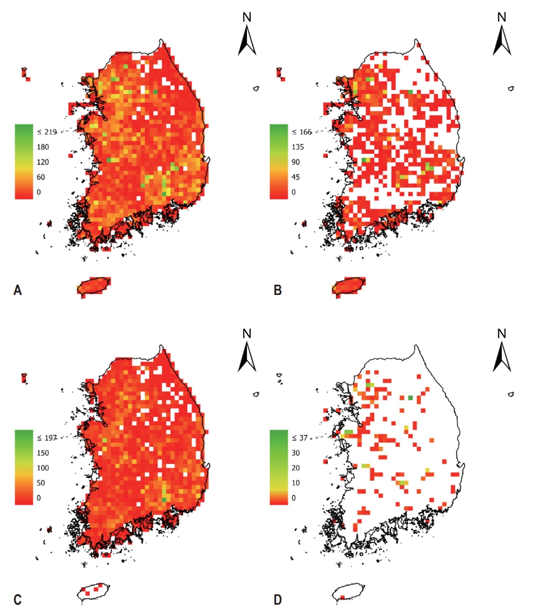


#816, 8-13, Gwangpyeong-ro 56-gil, Gangnam-gu, 06367 Seoul, South Korea
Tel: +82-2-6677-5682 E-mail: geodata@gaidas.org
Corporate registration number: 780-82-00418
