
Articles
- Page Path
- HOME > GEO DATA > Volume 6(1); 2024 > Article
-
Original Paper
태안 두웅습지 습지보호지역 식생공간분포 현황 -
신해선1
 , 이상훈2,*, 한상욱3
 - Vegetation Spatial Distribution on Taean Duung Wetland Protect Area
-
Haeseon Shin1, Sanghun Lee2,*, Sangwook Han3
-
GEO DATA 2024;6(1):8-13.
DOI: https://doi.org/10.22761/GD.2024.0004
Published online: March 28, 2024
1전임연구원, 국립생태원 습지센터 습지연구팀, 경상남도 창녕군 이방면 이산길 38, 50303, 대한민국
2팀장, 국립생태원 습지센터 습지연구팀, 경상남도 창녕군 이방면 이산길 38, 50303, 대한민국
3연구원, 국립생태원 습지센터 습지연구팀, 경상남도 창녕군 이방면 이산길 38, 50303, 대한민국
1Junior Researcher, Wetland Research Team, Wetland Center, National Institute of Ecology, 38 Isan-gil, Ibang-myeon, Changnyeong-gun, 50303 Gyeongsangnam-do, South Korea
2Team Leader, Wetland Research Team, Wetland Center, National Institute of Ecology, 38 Isan-gil, Ibang-myeon, Changnyeong-gun, 50303 Gyeongsangnam-do, South Korea
3Researcher, Wetland Research Team, Wetland Center, National Institute of Ecology, 38 Isan-gil, Ibang-myeon, Changnyeong-gun, 50303 Gyeongsangnam-do, South Korea
- Corresponding Author Sanghun Lee Tel: +82-55-530-5511 E-mail: sanghunlee@nie.re.kr
Copyright © 2024 GeoAI Data Society
This is an Open Access article distributed under the terms of the Creative Commons Attribution Non-Commercial License (http://creativecommons.org/licenses/by-nc/4.0/) which permits unrestricted non-commercial use, distribution, and reproduction in any medium, provided the original work is properly cited.
- 284 Views
- 21 Download
Abstract
- In this study, we conduct for providing information on the status of vegetation space distribution in the Duung wetland protected area and to help manage the wetland protected area. To understand the spatial distribution of vegetation in Duung Wetland, used the results of surveys in 2019 and 2023. As a result of the study, the number of vegetation types increased by 4 from 20 to 24. Four communities were newly investigated, including the Utricularia tenuicaulis community, Pueraria montana var. lobata-Elymus tsukushiensis community, Spiraea prunifolia for. simpliciflora community, and Miscanthus sinensis var. purpurascens community. In accordance with the environment, the range of aquatic plant communities such as Trapa japonica community and Nymphaea tetragona var. angusta community increased, and the succession zone of cultivated land expanded dry grassland. The survey results can be used as basic data for systematic management of the Duung wetland protected area.
- 습지는 육상과 수생생물 서식지의 전이지역 및 물로 덮여 있는 지역이나 물이 환경과 동식물의 생활을 조절하는 일차 요인인 지역으로(Moon, 2006; Ramachandra et al., 2005; Ramsar Convention Secretariat, 2013), 지구상에서 가장 영양 물질이 풍부하고 생산성이 높은 생태계로 인식되며 생태, 사회, 문화 그리고 경제적 가치 등 다양한 가치와 이점을 제공하고 있다(Kwon and Choi, 2009; Ministry of Environment, 2008; Mulamoottil et al., 1996; Ramachandra et al., 2005; Ramsar Convention Secretariat, 2013). 본 연구의 대상지인 두웅습지는 국내 습지보호지역 중 유일한 해안사구의 배후에 형성된 독특한 습지로서 지형적 가치가 높고, 수생생물 등이 밀생하여 어류의 산란과 은신처로서 좋은 서식지 역할을 하고 있는 것으로 알려져 있다(National Institute of Ecology, 2019). 또한 다른 담수호습지와 달리 사구 지하수와의 상호작용에 의해 수위가 유지되고 있으며, 집중호우 시에는 사구로부터 유입하는 담수를 저장하는 저류지 역할을 담당하는 한편, 갈수기에는 사구 지하수를 충전하는 함양원으로서 역할을 하고 있다. 이처럼 독특한 수문체계(hydrological system)를 가지고 있는 두웅습지는 금개구리 등 희귀 동·식물의 서식처로서 그 가치가 높은 것으로 알려져 있다(National Institute of Ecology, 2023). 그러나 사유지의 개발과 수위 감소 등의 원인으로 2010년 전후로 금개구리가 발견되지 않아 금강유역환경청에서 금개구리 복원 사업을 수행하는 등 관리를 하고 있다. 환경부(Ministry of Environment)는 두웅습지를 습지보호지역으로 지정한 이후 습지보전법 제4조에 따라 국가적 차원에서 정밀조사를 수행하고 있으며, 2009년, 2013년, 2019년, 2023년 총 4회에 걸쳐 두웅습지의 생태계 변화 및 훼손 현황 파악을 통해 습지보호지역 보전계획 수립 등을 지원하기 위한 과학적 근거 자료를 제시하고 있다(National Institute of Ecology, 2023). 그러나 그간의 두웅습지 조사 결과에 대한 학술적 연구는 미흡한 실정이다. 따라서 본 연구는 ‘내륙습지 정밀조사’의 2019년과 2023년 두웅습지 조사 결과를 통해 식생공간분포 현황을 분석하고 연도별 식생분포 변화상을 파악함으로써 습지보호지역의 체계적인 보전과 관리 방안 마련을 위한 기초 자료로 활용하고자 하였다.
1. 서론
- 2.1 대상 지역
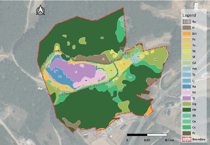
- 두웅습지는 충남 태안군 원북면 신두리 해안사구지대에 위치하고 있으며(Fig. 1), 희귀 야생 동·식물이 서식하는 가치를 인정받아 2002년에 환경부지정 7번째 습지보호지역으로 지정, 2007년에는 람사르습지로 등록되었다. 습지보호지역 면적은 0.067 km2이다.
- 2.2 조사 방법
- 본 연구의 데이터는 국립생태원에서 수행하고 있는 내륙습지 정밀조사의 2019년과 2023년 현존식생도 작성 결과를 활용하였다. 현존식생도(actual vegetation map)는 현존하는 식생의 공간 분포 양식을 나타낸 입지도(立地圖)로서 현재 토지이용 방식에 대한 빠르고, 정확한 식생학적 공간 분석을 포함한 토지 개발, 관리, 보전 등에 다양하게 이용될 수 있다(Kim and Lee, 2006). 현존식생도 작성의 기초 지도로 활용하기 위한 영상은 드론을 이용해 최신 영상을 직접 확보하였다. 2019년 영상은 2019년 6월 3일, 2023년 영상은 2023년 8월 19일에 촬영하여 자료를 획득하였으며, 현장조사를 통해 자료를 보완하였다. 현존식생도는 QGIS 프로그램의 3.28.15 버전을 이용하여 지도화하였으며, 면적 분석은 MS-Excel 등을 사용하였다.
2. 재료 및 방법
- 식생분포에 따른 두웅 습지 생태계 특성을 조사한 결과(Table 1), 총 24개의 유형으로 구분되었다. 이 중 식생 유형은 20개, 비식생 유형은 4개로 구분되었다. 이 중 수생식물 군락이 차지하는 비율은 전체 면적의 8.9%, 습생식물 군락은 7.9%를 차지하였으며, 건생식물 군락이 74.9%로 가장 많은 면적을 차지하였다. 수역을 포함한 비식생의 경우 8.3%의 비율을 나타냈다. 식생 유형 중 가장 큰 면적을 차지하는 군락은 건생식물 군락인 곰솔군락(37,670 m2)으로 전체 면적의 55.6% 비율을 보였으며, 가장 작은 면적은 수생식물 군락인 참통발군락(26 m2)으로 전체 면적의 0.04%를 자치하였다. 수생식물 군락과 습생식물 군락 중 가장 많은 비율을 차지하는 군락은 각각 마름군락(4,161 m2, 6.1%), 갈대군락(1,402 m2, 2.0%)으로 나타났다. 수역에 분포하는 식생은 깊은 수심에서 부터 호수-마름군락-수련군락-나도겨풀군락-갈대군락-큰매자기군락 순으로 분포하는 경향이 있었다.
- 2019년 정밀조사 결과와 비교한 결과(Figs. 2, 3), 2019년에는 총 20개의 유형이 확인되었으며, 2023년에 참통발군락, 칡-개밀군락, 조팝나무군락, 억새군락 등 4개 군락이 신규로 확인되었다. 식생 다양성에 영향을 미치는 칡은 분포 면적이 넓지 않아 습지에 미치는 영향은 낮은 것으로 보이나 확산 방지를 위한 관리가 필요한 것으로 나타났다. 신규로 조사된 4개 군락을 제외한 20개 유형은 2019년 출현 식생과 동일하였다. 비식생 유형을 포함한 군락 면적을 비교하였을 때 2019년과 면적이 동일한 군락이 버드나무군락, 삿갓사초군락 등 6개, 증가한 군락이 나도겨풀군락, 마름군락, 수련군락 등 5개, 감소한 군락이 큰매자기군락, 건생초지, 수역 등 9개로 확인되었다. 이 중 큰매자기군락은 2019년 분포 면적 1,543 m2에서 321 m2로 감소하였고, 나도겨풀군락은 157 m2에서 1,497 m2로 증가한 것으로 나타났는데, 분포 위치를 보았을 때 2019년 큰매자기군락이 분포하였던 곳에 2023년 나도겨풀군락이 차지하고 있는 것으로 보아 두웅습지 호수 내 유량의 증가로 인해 수변부에 서식하는 큰매자기군락이 감소하고 나도겨풀군락이 증가한 것이 원인으로 사료된다. 또한 2019년 경작지로 조사된 일부가 2023년에는 건생초지로 조사되었는 데 이는 2019년 이후 경작 활동이 이루어지지 않아 폐경작지가 건생초지로 천이한 것으로 판단된다. 이와 같이 경작지 일부가 건생초지로 천이됨에도 불구하고 일부 건생초지가 칡-개밀군락으로 분류되어 2023년 건생초지 면적(5,809 m2) 은 2019년(7,046 m2)에 비해 감소한 것으로 나타났다. 수역(1,740 m2)의 경우 2023년 수생식물 분포 면적이 증가하여 2019년(2,184 m2)에 비해 다소 감소한 것으로 나타났다. 기타 산조풀군락, 갈대군락과 억새군락 등 호수에 인접한 군락에 대한 질적 양적 변화는 조사 시기의 차이와 수심, 기온 등 환경의 변화에 따라 차이가 나는 것으로 판단된다.
- 식생 유형별 면적의 비교는 동일 식생이라 하더라도 조사 시기가 2019년은 6월, 2023년은 8월로 차이가 있어 연도에 따른 정확한 면적 비교에는 한계가 있었다.
3. 결과 및 논의
- 두웅습지의 2019년과 2023년의 식생공간분포 변화를 분석한 결과, 식생의 변화는 대체로 없었으나 참통발군락, 칡-개밀군락, 조팝나무군락, 억새군락 등 4개 군락이 신규로 확인되었고, 환경 변화에 따른 마름군락, 수련군락 등 수생식물 분포 면적의 증가, 경작지의 천이로 인한 건생초지 면적 확대 등이 조사되었다. 두웅습지는 습지보호지역 지정 이후 지역 관광지 및 생태탐방의 공간으로 운영되고 있어 탐방객으로 인한 생태계교란 생물 및 귀화식물 유입이 이루어질 수 있는 환경이었다. 따라서 생태계교란 생물의 분포 상태를 모니터링하여 확산을 대비하는 등 두웅습지의 지속적인 정비와 관리가 필요한 것으로 판단된다. 또한, 두웅습지 북측에 위치한 논 경작지의 경우 오랜 기간 동안 두웅습지 내 위치하고 있어 생물 다양성 증가에 도움이 되고 있는 것으로 확인되나, 경작이 이루어지는 과정에서 오염원의 유입을 배제할 수 없어 친환경 경작이 이루어지도록 관리가 필요한 것으로 나타났다. 두웅습지 식생에 대한 자연 천이를 유도 및 유지하기 위해서는 마름군락, 수련군락 및 참통발군락 등 수생식물에 대한 지속적인 식생 면적 변화의 모니터링이 필요하며, 마름군락 및 수련군락의 확장 제어시스템을 구축하여 습지 내 생태계의 급격한 변화가 발생하지 않도록 중·장기적인 관리 계획을 세워야 할 것으로 판단된다.
4. 결론
-
Conflict of Interest
Sanghun Lee has been an Editorial Board of GEO DATA; however, he was not involved in the peer reviewer selection, evaluation, or decision process of this paper. Otherwise, no other potential conflicts of interest relevant to this paper were reported.
-
Funding Information
This study was funded by the project, “Intensive Survey on the Inland Wetland”, grant numbers NIE-A-2024-19 from the National Institute of Ecology (NIE).
-
Data Availability Statement
The data that support the findings of this study are openly available in Ecobank(http://nie-ecobank.kr/) at http://doi.or.kr/10.22756/GEO.20240000000843.
Notes


- Kim JY, Lee YG (2006) Classification and Assessment of Plant Communities. Worldscience, Seoul, 240p
- Kwon YH, Choi HK (2009) The Impact of Climate Change on the Ecosystem: The Case of Wetland Plants. Korea Environment Institute, Seoul, 131p
- Ministry of Environment (UNDP/GEF Management Agency of National Wetland Preservation Program) (2008) A Guide to the Third National Inland Wetlands Research. Ministry of Environment, Sejong, 288p
- Moon HS (2006) The conprehesion of the terminology of wetlands. Journal of the Speleological Society of Korea 75:35–39
- Mulamoottil G, Warner BG, McBean EA (1996) Wetlands: Environmental Gradients, Boundaries and Buffers. Lewis Publisher, Boca Raton, 320p
- National Institute of Ecology (2019) The 3rd Intensive Survey on the Wetland Protected Areas (’19). National Institute of Ecology, Seocheon, 764p
- National Institute of Ecology (2023) Intensive Survey National Inland Wetlands (‘23). National Institute of Ecology, Seocheon, 1460p
- Ramachandra TV, Rajinikanth R, Ranjini VG (2005) Economic valuation of wetlands. J Environ Biol 26(2 suppl):439–447PubMed
- Ramsar Convention Secretariat (2013) The Ramsar Convention Manual, A Guide to the Convention on Wetlands. Ramsar Convention Secretariat, Ramsar, p. 7–10
References
Appendix
| Sort | Field | Subcategory#1 | Subcategory#2 |
|---|---|---|---|
| Essential | *Title | Duung Wetland Protect Area current vegetaion map (2019 year, 2023 year) | |
| *DOI | http://doi.or.kr/10.22756/GEO.20240000000843 | ||
| *Category | Biota | ||
| *Temporal Coverage | 2019, 2023 | ||
| *Spatial Coverage | Taean-gun | Republic of Korea | |
| WGS84 Coordinates | [36.836667, 126.195061], [36.836862, 126.198817] | ||
| *Personnel | Name | Haeseon Shin | |
| Affiliation | National Institute of Ecology | ||
| hs3060@nie.re.kr | |||
| *CC License | CC BY-NC | ||
| Optional | *Project | Intensive Survey on the Inland Wetland | |
| *Instrument | QGIS 3.28.15 |
Figure & Data
References
Citations
 PubReader
 ePub Link
 Cite
Cite


#816, 8-13, Gwangpyeong-ro 56-gil, Gangnam-gu, 06367 Seoul, South Korea
Tel: +82-2-6677-5682 E-mail: geodata@gaidas.org
Corporate registration number: 780-82-00418
