
Articles
- Page Path
- HOME > GEO DATA > Volume 5(2); 2023 > Article
-
Original Paper
한국의 생태계교란 식물의 분포 현황 데이터 -
신만석1,†
 , 홍유진2,†, 이상훈3,*
 - Dataset on the Distribution of Ecosystem-Disturbing Plants in the Republic of Korea
-
Man-Seok Shin1,†, Yu Jin Hong2,†, Sanghun Lee3,*
-
GEO DATA 2023;5(2):66-76.
DOI: https://doi.org/10.22761/GD.2023.0009
Published online: June 27, 2023
1전임연구원, 국립생태원 생태정보팀, 충청남도 서천군 마서면 금강로 1210, 33657, 대한민국
2학부생, 가톨릭대학교 생명공학과, 경기도 부천시 지봉로 43, 14662, 대한민국
3팀장, 국립생태원 생태정보팀, 충청남도 서천군 마서면 금강로 1210, 33657, 대한민국
1Researcher, Ecological Information Team, National Institute of Ecology, 1210 Geumgang-ro, Maseo-myeon, Seocheon-gun, 33657 Chungcheongnamdo, South Korea
2Undergraduate Student, Department of Biotechnology, The Catholic University of Korea, 43 Jibong-ro, Bucheon, 14662 Gyeonggi-do, South Korea
3Team Leader, Ecological Information Team, National Institute of Ecology, 1210 Geumgang-ro, Maseo-myeon, Seocheon-gun, 33657 Chungcheongnamdo, South Korea
- Corresponding Author Sanghun Lee Tel: +82-41-950-5621 E-mail: sanghunlee@nie.re.kr
- †These authors contributed equally to this work.
Copyright © 2023 GeoAI Data Society
This is an Open Access article distributed under the terms of the Creative Commons Attribution Non-Commercial License (http://creativecommons.org/licenses/by-nc/3.0/) which permits unrestricted non-commercial use, distribution, and reproduction in any medium, provided the original work is properly cited.
- 1,041 Views
- 98 Download
Abstract
- In this study, we presented distribution data for 16 plant species designated as ecosystem-disturbing species by the Ministry of Environment of the Republic of Korea. These data include location information for the ecosystem-disturbing plants from four survey projects (Monitoring of invasive alien species designated by the wildlife protection act, Nationwide survey of non-native species in Korea, The 3rd and 4th national ecosystem survey) conducted by two agencies (National Institute of Ecology and National Institute of Environmental Research) between 2014 and 2021. Additionally, the data includes habitat environmental characteristics and administrative district information on the survey sites of the ecosystem-disturbing plants. These data have a high potential for utilization as basic information for natural environmental policies and related research by identifying the habitat characteristics of invasive alien species.
- 침입외래종은 20세기 이후 생물다양성에 가장 큰 위협 요소로 거론되고 있다(Park et al., 2016). 국제적으로 다양한 상품이 거래되고, 전 세계가 하나의 생활권을 형성함에 따라 많은 외래 동·식물이 국내에 유입되고 있다(Ministry of Environment and National Institute of Ecology, 2021). 우리나라는 이러한 외래 동·식물에 대하여 ‘유입주의생물’, ‘생태계위해우려생물’, ‘생태계교란 생물’로 구분하여 법정관리종으로 다루고 있다(Kim and Koo, 2021). 이 중에서 ‘생태계 교란 생물’은 「생물다양성 보전 및 이용에 관한 법률」 제2조에서 “생태계 등에 미치는 위해가 큰 것으로 판단되어 환경부 장관이 지정·고시하는 것”이라고 정의하고 있다. 국립생태원은 생태계교란 생물 및 외래생물의 영향 파악과 관리를 위하여 “생태계교란 생물 모니터링”, “외래생물 전국 서식실태 조사” 등을 실시하고 있다.
- 생태계교란 생물 관리의 성공과 실패는 적절한 시기의 관리 활동에 따라 좌우된다. 적절한 생태계교란 생물의 관리체계 및 전략을 수립하기 위해서는 생물 종 특성, 생물 유입 지역의 환경, 확산 가능성, 지형의 구조와 연결 등 다양한 요인을 고려하여야 한다(Ministry of Environment and National Institute of Ecology, 2021). 본 데이터는 환경부고시(제 2021-176호)를 통해 지정된 생태계교란 생물(포유류 1종, 양서·파충류 6종, 어류 3종, 갑각류 1종, 곤충류 8종, 식물 16종) 중에서 식물 종을 대상으로 전국 분포 지점 및 서식환경 정보를 수집하여 정리하였다. 국립생태원에서 관리하고 있는 전국 단위의 조사사업에서 생태계교란 식물 정보를 취합하여, 우리나라 생태계교란 식물의 효율적 관리체계 마련을 위한 기초자료를 제공하고자 하였다.
1. 서론
- 2.1 자료 취득
- 환경부고시 제2021-176호(2021.08.31) 기준으로 지정된 생태계교란 생물 중 식물 16종을 대상으로 국립생태원과 국립환경과학원 조사 결과에 기록된 분포 지점(좌표)을 수집하였다. 국립생태원의 생태계교란 생물 모니터링(National Institute of Ecology, 2014; National Institute of Ecology, 2015a; National Institute of Ecology, 2016a; National Institute of Ecology, 2017a; National Institute of Ecology, 2018a; National Institute of Ecology, 2019a; National Institute of Ecology, 2020a; National Institute of Ecology 2021a), 외래생물 전국 서식실태조사(National Institute of Ecology, 2015b; National Institute of Ecology, 2016b; National Institute of Ecology, 2017b; National Institute of Ecology, 2018b; National Institute of Ecology, 2019b; National Institute of Ecology, 2020b; National Institute of Ecology, 2021b) 그리고 제4차 전국자연환경조사(National Institute of Ecology, 2015c; National Institute of Ecology, 2016c; National Institute of Ecology, 2017c; National Institute of Ecology, 2018c; National Institute of Ecology, 2019c) 연구 사업에서 기록된 식물 분포 지점을 활용하였다. 그리고 국립환경과학원 제3차 전국자연환경조사(National Institute of Environmental Research, 2007; National Institute of Environmental Research, 2008; National Institute of Environmental Research, 2009; National Institute of Environmental Research, 2010; National Institute of Environmental Research, 2011; National Institute of Environmental Research, 2012)의 결과를 추가로 활용하여 생태계교란 생물(식물) 종의 분포 지점 자료를 수집하였다(Table 1). 종 학명은 국립생물자원관 한반도의 생물다양성(https://species.nibr.go.kr/)에서 제공하는 국가생물종목록을 기준으로 정리하였다.
- 2.2 조사사업 개요
- 생태계교란 생물 모니터링은 「생물다양성 보전 및 이용에 관한 법률」로 지정된 생태계교란 생물에 의한 영향 파악 및 관리를 위하여 각 종별 분포 현황 등에 대한 지속적인 모니터링을 주 목적으로 하는 조사사업이다(National Institute of Ecology, 2014). 본 사업에서 생태계교란 식물의 조사 방법은 전국 분포 지점 중 현장 확인을 통하여 각 종별 10개 내외의 조사지역을 선정하여 GPS를 이용한 위치 좌표 및 분포 환경 특성 등을 기록한다(National Institute of Ecology, 2014). 본 데이터는 생태계교란 생물 모니터링 사업의 2014년부터 2021년까지 조사된 자료가 활용되었다.
- 외래생물 전국 서식실태조사는 3개 분야 목적(① 외래생물 분포도 제공을 통해 효율적 관리 기반 구축, ② 외래생물 목록화를 위한 기초 자료 수집, ③ 잠재적 위해 외래생물 파악으로 조기관리 기능 강화)을 달성하기 위해 수행하는 조사 사업이다(National Institute of Ecology, 2015b). 본 사업은 2014년에 환경부에서 발간된 “외래생물 중장기 관리방안 연구”에서 제시한 국내 유입 외래생물 2,167종을 대상으로 분포 조사를 실시한다(National Institute of Ecology, 2015b). 식물 조사 방법은 생태계교란 생물로 지정된 종들을 중점 조사하고 미기록 귀화식물 발견 시 확증표본을 작성한다(National Institute of Ecology, 2015b). 본 데이터는 외래생물 전국서식실태조사 사업의 2015년부터 2021년까지 조사된 자료가 활용되었다.
- 전국자연환경조사는 「자연환경 보전법」 제30조에 근거하여 전국의 자연환경을 5년 기준으로 조사하는 사업이다. 제1차 사업을 1986년에 시작하여 2023년 현재, 제5차 사업이 진행 중에 있다. 본 연구에서는 제3, 4차 사업의 식물상 조사 결과가 반영되었다. 제3, 4차 식물상 조사는 관속식물(양치, 나자 및 피자식물)을 대상으로 전국을 1/25,000 도엽으로 구분하고 도엽을 대표할 만한 산지와 수변지역을 중심으로 조사 지역을 선정하여 1년에 3회(봄, 여름, 가을) 이상 실시한다(Ministry of Environment and National Institute of Environmental Research, 2012). 본 데이터는 제3차 전국 자연환경조사 사업의 2008년부터 2012년까지 조사된 자료와 제4차 전국자연환경조사 사업의 2014년부터 2018년까지 조사된 자료가 활용되었다.
- 2.3 자료 구축
- 수집된 생태계교란 식물 위치 정보를 기반으로 공간 정보(점 형태의 벡터 형식)를 구축하였다. 구축된 공간 정보는 수집에 활용된 보고서와 비교하여 오류를 검수하였다. 생태계교란 식물이 발견된 지점과 서식환경(비생물 환경)을 비교 분석할 수 있도록 구축된 공간 정보를 기반으로 생물기후 변수(bioclimatic variable, Bioclim), 토지피복(land-use), 해발고도(elevation), 행정구역(administrative regions) 정보를 추출하여 데이터에 포함하였다(Table 2). 최종 구축된 생태계교란 식물 공간 정보의 속성 정보는 Table 3과 같다.
2. 본론
2.2.1 생태계교란 생물 모니터링
2.2.2 외래생물 전국 서식실태조사
2.2.3 전국자연환경조사
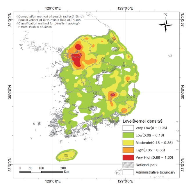
- 생태계교란 식물 16종의 총 20,006개 조사 위치 정보를 데이터베이스(database)로 구축하였다(Fig. 1). 가장 많이 조사된 종은 환삼덩굴로 6,041개 지점이 발견되었다. 이어서 미국쑥부쟁이(3,101개 지점), 돼지풀(2,984개 지점), 단풍잎돼지풀(2,122개 지점), 가시상추(1,913개 지점) 종 순으로 분포가 확인된 지점이 많았다(Table 1). 생태계교란 식물이 가장 많이 발견된 행정구역은 경기도였고(4,732개 지점), 그 다음으로 강원도(3,252개 지점), 경상북도(3,066개 지점), 경상남도(1,607개 지점) 순으로 나타났다(Fig. 2, Table 4). 서울특별시와 광주광역시를 제외한 모든 행정구역에서 생태계교란 식물이 발견되는 비율이 농업지역에서 가장 높게 나타났다(Table 4, Fig. 3).
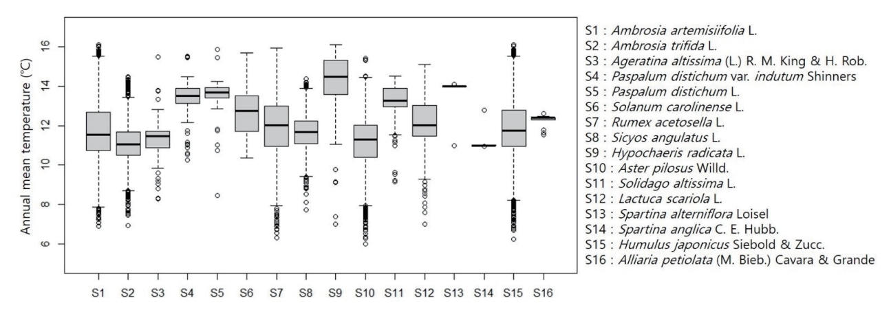
- 생태계교란 식물이 가장 많이 발견된 토지피복 분류 유형은 농업지역(agricultural land)으로 7,112개 지점이 기록되었고, 이어서 시가화·건조지역(used area) 3,831개 지점, 산림지역(forest) 3,701개 지점, 습지(wet land) 1,365개 지점, 수변지역을 포함한 수역(water) 1,357개 지점, 초지(grass) 1,338개 지점, 나지(barren) 1,302개 지점 순으로 나타났다(Fig. 4). 토지피복 분류 유형 중 농업지역과 시가화·건조지역에서 발견된 지점이 다수(54.6%)를 차지하였다. 생태계교란 식물 각 종별로 가장 많이 발견된 토지피복 분류 유형은 종별로 차이가 있었다(Table 5, Fig. 5). 16개 종 중에서 11개 종(돼지풀, 단풍잎돼지풀, 털물참새피, 물참새피, 도깨비가지, 가시박, 서양금혼초, 미국쑥부쟁이, 양미역취, 가시상추, 환삼덩굴)이 농업지역에서 가장 많이 발견되었고, 3개 종(서양등골나물, 애기수영, 마늘냉이)은 산림지역에서, 나머지 2종(갯줄풀, 영국갯끈풀)은 수변지역을 포함한 수역에서 가장 많이 발견되었다. 또한 16종 생태계교란 식물이 발견된 조사 지점의 해발고도의 특징은 100 m 이하의 지점이 전체 63% (12,627개 지점)로 나타났고, 500 m 이하는 95% (19,205개 지점)로 나타났다(Fig. 6). 해발고도 100 m 이상부터 발견된 지점이 급격히 줄어드는 양상을 보였다. 생태계교란 생물이 발견된 지점의 연평균 기온(BIO_01)은 11.74℃였고, 범위는 최소 6.01℃에서 최대 16.1℃로 나타났다. 각 종별로 비교해 보면, 가장 조사 지점이 많은 환삼덩굴의 연평균 기온 범위가 가장 넓었다(Min 6.24℃ to Max 16.1℃; Fig. 7).
3. 결과
- 본 데이터는 환경부에서 지정하는 생태계교란 생물 중에서 식물 16종의 분포 지점 조사 자료와 서식 특징을 살펴볼 수 있는 환경 정보를 정리하였다. 2014년부터 2021년까지 국립생태원과 국립환경과학원이 국립생태원에 이관하여 수행한 생태계교란 식물과 관련된 조사 사업을 정리하였기 때문에 활용가치가 높을 것으로 판단된다.
- 본 데이터는 기후 변화의 영향으로 침입외래종이 증가할 수 있는 현재 상황에서 생태계교란 생물에 대한 효율적 관리 및 조기대응 방안 마련 등 외래 생물 관련 정책 수립의 기초 자료로 활용될 수 있다. 또한 본 데이터는 생태계교란 식물이 발견된 지점과 함께 해당 지점의 생물기후 변수와 토지피복 자료가 포함되어 있다. 따라서 기후 변화에 따른 생태계교란 식물의 확산 예측, 유입 지역의 환경 특성을 반영한 서식지 예측 등 향후 퇴치 및 확산 통제를 위한 전략적 관리방안에 활용될 가능성이 크다.
- 본 데이터에서 정리한 16종 중에서 3종(갯줄풀, 영국갯끈풀, 마늘냉이)은 발견된 지점이 매우 적어 본 자료만으로 서식 특징을 판단하기에 어려움이 있을 것으로 보인다. 본 데이터에서 고려된 3개 조사 사업(생태계교란 생물 모니터링, 외래생물 전국서식실태조사, 전국자연환경조사)은 자연생태계와 자연·문화 경관의 보전성이 높은 국립공원을 중점적으로 조사하지 않았기 때문에 국립공원을 범위 대상으로 본 데이터를 활용할 경우 이러한 측면을 고려하여 사용에 대한 주의가 필요하다.
4. 결론 및 토의
-
Conflict of Interest
On behalf of all authors, the corresponding author states that there is no conflict of interest.
-
Funding Information
This study was supported by a grant from the National Institute of Ecology (NIE), funded by the Ministry of Environment (MOE) of the Republic of Korea (NIE-A-2023-01, NIE-A-2023-09, NIE-A-2023-12, NIE-B-2023-01).
-
Data Availability Statement
The data that support the findings of this study are openly available in EcoBank (https://nie-ecobank.kr/) at http://doi.or.kr/10.22756/GEO.20230000000825.
Notes


- Kim DB, Koo KA (2021) A study on the current status and improvement of ecosystem disturbance species. J Environ Policy Adm 29:59–81Article
- Ministry of Environment (MOE) and National Institute of Ecology (NIE) (2021) Information for the Field Management of Invasive Alien Species in Korea. MOE and NIE, Sejong
- Ministry of Environment (MOE) and National Institute of Environmental Research (NIER) (2012) Establishment of the 4th National Ecosystem Survey Guidelines. MOE and NIER, Incheon
- National Institute of Ecology (NIE) (2014) Monitoring of Invasive Alien Species Designated by the Wildlife Protection Act (I). NIE, Seocheon
- National Institute of Ecology (NIE) (2015a) Monitoring of Invasive Alien Species Designated by the Wildlife Protection Act (II). NIE, Seocheon
- National Institute of Ecology (NIE) (2015b) Nationwide Survey of Non-native Species in Korea (I). NIE, SeocheonPubMed
- National Institute of Ecology (NIE) (2015c) The 4th National Ecosystem Survey (2014). NIE, Seocheon
- National Institute of Ecology (NIE) (2016a) Monitoring of Invasive Alien Species Designated by the Act on the Conservation and Use of Biological Diversity (III). NIE, Seocheon
- National Institute of Ecology (NIE) (2016b) Nationwide Survey of Non-native Species in Korea (II). NIE, Seocheon
- National Institute of Ecology (NIE) (2016c) The 4th National Ecosystem Survey (2015). NIE, Seocheon
- National Institute of Ecology (NIE) (2017a) ) Monitoring of Invasive Alien Species Designated by the Act on the Conservation and Use of Biological Diversity (IV). NIE, Seocheon
- National Institute of Ecology (NIE) (2017b) Nationwide Survey of Non-native Species in Korea (III). NIE, Seocheon
- National Institute of Ecology (NIE) (2017c) The 4th National Ecosystem Survey (2016). NIE, Seocheon
- National Institute of Ecology (NIE) (2018a) Monitoring of Invasive Alien Species Designated by the Act on the Conservation and Use of Biological Diversity (V). NIE, Seocheon
- National Institute of Ecology (NIE) (2018b) Nationwide Survey of Non-native Species in Korea (IV). NIE, Seocheon
- National Institute of Ecology (NIE) (2018c) The 4th National Ecosystem Survey (2017). NIE, Seocheon
- National Institute of Ecology (NIE) (2019a) Monitoring of Invasive Alien Species Designated by the Act on the Conservation and Use of Biological Diversity (VI). NIE, Seocheon
- National Institute of Ecology (NIE) (2019b) Nationwide Survey of Non-native Species in Korea (V). NIE, Seocheon
- National Institute of Ecology (NIE) (2019c) The 4th National Ecosystem Survey (2018). NIE, Seocheon
- National Institute of Ecology (NIE) (2020a) Monitoring of Invasive Alien Species Designated by the Act on the Conservation and Use of Biological Diversity. NIE, Seocheon
- National Institute of Ecology (NIE) (2020b) Nationwide Survey 2020 of Non-native Species in Korea. NIE, Seocheon
- National Institute of Ecology (NIE) (2021a) Monitoring of Invasive Alien Species Designated by the Act on the Conservation and Use of Biological Diversity. NIE, Seocheon
- National Institute of Ecology (NIE) (2021b) Nationwide Survey of Non-native Species in Korea. NIE, Seocheon
- National Institute of Environmental Research (NIER) (2007) The 3th National Ecosystem Survey (2006). NIER, Incheon
- National Institute of Environmental Research (NIER) (2008) The 3th National Ecosystem Survey (2007). NIER, Incheon
- National Institute of Environmental Research (NIER) (2009) The 3th National Ecosystem Survey (2008). NIER, Incheon
- National Institute of Environmental Research (NIER) (2010) The 3th National Ecosystem Survey (2009). NIER, Incheon
- National Institute of Environmental Research (NIER) (2011) The 3th National Ecosystem Survey (2010). NIER, Incheon
- National Institute of Environmental Research (NIER) (2012) The 3th National Ecosystem Survey (2011). NIER, Incheon
- Park YH, Kim J, Jung H (2016) Climate change and ecosystem-based management strategies of invasive alien species. JEPA 24(4):149–176Article
References
Appendix
| Sort | Field | Subcategory#1 | Subcategory#2 |
|---|---|---|---|
| Essential | *Title | Dataset on the distribution of invasive alien plants | |
| *DOI name | http://doi.or.kr/10.22756/GEO.20230000000825 | ||
| *Category Abstract | Biota | ||
| *Temporal Coverage | 8 years | From 2014 to 2021 | |
| *Spatial Coverage | Address | None | |
| WGS84 Coordinates | Point | ||
| Latitude 33.20°N to 38.59°N | |||
| Longitude 124.64°E to 130.91°E | |||
| *Personnel | Name | Man-Seok Shin | |
| Affiliation | National Institute of Ecology | ||
| manhae@nie.re.kr | |||
| *CC License | CC BY-NC | ||
| Optional | *Project | Improvement and maintenance of EcoBank (1st year) | Monitoring of invasive alien species designated by the wildlife protection act (2014-2021) |
| Nationwide survey of non-native species in Korea (2015-2021) | |||
| The 3th national ecosystem survey (2007-2012) | |||
| The 4th national ecosystem survey (2015-2019) | |||
| *Instrument | ArcGIS 10.5 | ESRI |
Figure & Data
References
Citations
 PubReader
 ePub Link
 Cite
Cite


#816, 8-13, Gwangpyeong-ro 56-gil, Gangnam-gu, 06367 Seoul, South Korea
Tel: +82-2-6677-5682 E-mail: geodata@gaidas.org
Corporate registration number: 780-82-00418
