
Previous issues
- Page Path
- HOME > Articles and Issues > Previous issues
- Volume 4(2); June 2022
-


Articles
- UAV Photogrammetry and LiDAR Based Dataset of Spartina anglica Distribution and High-resolution Topographic Map in Ganghwado
- Keunyong Kim, Yeongjae Jang, Jingyo Lee, Joo-Hyung Ryu
- GEO DATA. 2022;4(2):1-8. Published online June 30, 2022
- DOI: https://doi.org/10.22761/DJ2022.4.2.001

- 944 View
- 55 Download
- 1 Citations
-
 Abstract
 PDF
PDF - The Spartina anglica in the tidal flat at the southern part of Ganghwado, it is known that the distribution area has gradually expanded since it was officially announced as invasive alien species in 2015. The government and local governments are continuing their efforts to remove the S. anglica, and for this, continuous distribution change monitoring is required. This study extracted the data of distribution and extent area of S. anglica from Zenmuse P1 sensor, and generated the high-resolution Digital Elevation Model (DEM) from Zenmuse L1 sensor. Optical and Lidar images were photographed at an altitude of 70 m, and Ground Sampling Distance (GSD) of optical images was obtained at 0.9 cm and GSD of lidar images at 5 cm spatial resolution. However, the data are resampled and provided in GSD 25 cm to comply with the "National Spatial Information Security Management Regulations of the Ministry of Land, Infrastructure and Transport" and "Security Business Regulations of the National Intelligence Service".
-
Citations
Citations to this article as recorded by
- Spartina anglica-Derived Carbon-Coated PE Separator for Physically Restraining Polysulfide Migration in Lithium-Sulfur Batteries
Ye Jin Jeon, Yuna Ha, Jang Kyun Kim, Youn-Jung Kim, Taeeun Yim
Korean Journal of Chemical Engineering.2024; 41(4): 1187. CrossRef
- Spartina anglica-Derived Carbon-Coated PE Separator for Physically Restraining Polysulfide Migration in Lithium-Sulfur Batteries
- A Geological Environment Characteristics Dataset of Tidal Flat Surface Sediments: A 2021 Pilot Study of the Gomso Bay Tidal Flat Area to Use of Sediment Type Data
- Kyoungkyu Park, Han Jun Woo, Hoi-Soo Jung, Joo Bong Jeong, Joo-Hyung Ryu, Jun-Ho Lee
- GEO DATA. 2022;4(2):9-22. Published online June 30, 2022
- DOI: https://doi.org/10.22761/DJ2022.4.2.002
- 785 View
- 31 Download
- 1 Citations
-
Abstract
PDF
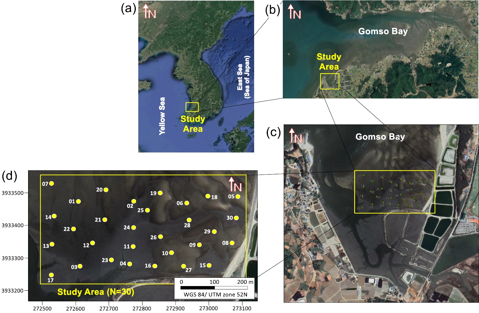
- The Gomso Bay tidal flat is located between Buan-gun and Gochang-gun in Jeollabuk-do, Korea; it is a semi-closed bay in an area where tides prevail over waves. Tidal flats are mainly found south of Gochang-gun, and the main stream located north of the tidal flats is about 15 m deep and 900 m wide at low tide. Limited direct sampling is necessary for analyzing the geological environment of intertidal tidal flats, depending on the expected ebb-tide time and the number of survey items allowed for tidal flat access. This study assessed field measurement and laboratory analysis items for obtaining and establishing geological environment data to use of sediment type data in a pilot research area in the Gomso Bay tidal flat. Thirty sites were examined on June 22 and 24, 2021 (survey time about 3.5 hours for the 2 days). The field measurements were the sample date (year/month/day/hour/minute), ellipsoid height using a real-time kinematics global positioning system (RTK GPS) (m), shear strength (kg/cm2), and Munsell color. Samples for particle size (phi, Φ), specific density, porosity (%), moisture content (%), total organic carbon (%), total carbon (%) and total nitrogen (%) were placed in zipper bags and polypropylene (PP) bottles. The sedimentary phases were classified following Folk and Ward (1957), the organic matter was characterized based on particle size analysis and each experimental result was verified. In the future, a geological environment characteristics dataset based on this pilot study will be used as basic data to assess changes in the tidal flat topography and sedimentation environment. It should be useful data for research, tidal flat environment conservation management and free open data for users of related researchers.
-
Citations
Citations to this article as recorded by- Characteristics of temporal-spatial variations of zooplankton community in Gomso Bay in the Yellow Sea, South Korea
Young Seok Jeong, Min Ho Seo, Seo Yeol Choi, Seohwi Choo, Dong Young Kim, Sung-Hun Lee, Kyeong-Ho Han, Ho Young Soh
Environmental Biology Research.2023; 41(4): 720. CrossRef
- Characteristics of temporal-spatial variations of zooplankton community in Gomso Bay in the Yellow Sea, South Korea
- Spatial Distribution Characteristics of Seagrass Habitat Based on Remote Sensing Data: Focusing on Wan Island
- Jung Yoon Yeo, Joo Bong Jeong, Jong Kyu Kim
- GEO DATA. 2022;4(2):23-36. Published online June 30, 2022
- DOI: https://doi.org/10.22761/DJ2022.4.2.003

- 792 View
- 33 Download
-
Abstract
PDF
- In May 2019, UAV photogrammetry using drones (unmanned aircraft) was conducted to investigate the spatial distribution characteristics of the seagrass habitat in Wan Island. Wan Is. sea was divided into 3 geographical areas (Site A, B, C) by referring to the seagrass distribution identified by the National Coastal seagrass forest precision survey (Ministry of Oceans and Fisheries, 2015), and contour lines were extracted from grid depth data. In addition, a 3-D benthic topographic map using DTM (Digital Terrain Model) was created to understand the characteristics and slope of the benthic topographic map. Through the analysis of the seagrass distribution results and the water depth results, it was confirmed that the boundary between the seagrass distribution in the outer and coastal areas converges to different water depth limits (within 10 m, and within 5 m), which is estimated to be based on the characteristics of the outer sea area. As a result of the analysis of the benthic topography, it was confirmed that the slope of the well-covered distribution was relatively gentle below 0.2~0.8 degrees, and the well-covered distribution was limited to the vicinity of the boundary where the slope changed rapidly. As a result of comparing the area of the seagrass distribution survey in 2015 and 2019, it was confirmed that the area was 238.4 ha and 1,070.9 ha, respectively, which was 4.5 times more widerly when performing Drone survey than diving survey. In order to understand the surrounding environment of the seagrass distribution site, satellite image data and license fishing ground information map at the time of drone shooting (May 2019) were checked. As a result, seaweed (Kelp, Sea mustard seaweed, Seaweed, Seaweed fulvescens, etc.) and shellfish (Abalone) were densely distributed, and most of the facilities except for Seaweed fulvescens farms were separated from their habitat. Drone survey confirmed Zostera marina, Zostera caulescens, and Zostera japonica in Wan Is., but no Phyllospadix iwatensis and Halophila nipponica were identified in 2015. It was confirmed that there was a limit to classifying the types of vegetation due to the characteristics of Phyllospadix iwatensis attached to the rock substrate, and in the case of Halophila nipponica with short leaves of 2 to 3 cm, they were not exposed to the water even at low tide, so there was a limit to detection using drones. These research results are expected to be useful data for grasping the characteristics of a wide range of seagrass habitats in other seas in the future.
- Construction of a Training Dataset for Vessel Distribution Prediction: The Northern Seas of Jeju Island
- Yonggil Park, Taehoon Kim, Hyeon-Gyeong Han, Cholyoung Lee
- GEO DATA. 2022;4(2):37-46. Published online June 30, 2022
- DOI: https://doi.org/10.22761/DJ2022.4.2.004
- 567 View
- 38 Download
-
Abstract
PDF
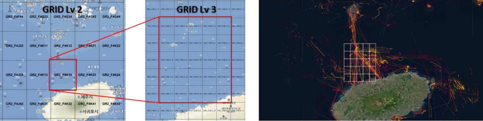
- Recently, interest in maritime accidents and safety-related research, such as preventing collisions between marine vessels, detecting illegal vessels, and predicting vessel routes, is increasing. Vessel location data-based vessel distribution map can support decision-making for maritime safety management, and if the vessel distribution can be predicted, it is possible to take a preemptive response for maritime security such as fishing safety management and illegal fishing prevention. In this study, a training dataset for vessel distribution prediction was constructed by collecting V-Pass data, weather warnings, and marine environment data. The result of resampling of reporting interval of vessel location data was mapped to grid data to evaluate the vessel density, and a total of 1,314,000 of training data were constructed for the study area. In the future, research to evaluate the accuracy by performing vessel distribution prediction modeling should be conducted.
Note
- Is the ocean science data repository, JOISS able to be FAIR?
- Tae Yoon Song, Ji Yoon Lee, Woo Ram Kim, Soyeona Park, Tae Keun Rho
- GEO DATA. 2022;4(2):47-56. Published online June 30, 2022
- DOI: https://doi.org/10.22761/DJ2022.4.2.005
- 537 View
- 22 Download
-
Abstract
PDF
- As the global open science movement has recently proven its effectiveness in responding to the corona pandemic, research on disciplinary or institutional data repositories and establishing service platforms for the open and sharing research data are also active in Korea. The purpose of the research data repository is not to manage data per se but to discover and innovate knowledge and to integrate and reuse subsequent data and knowledge. Therefore, recent repository-related studies emphasize implementing the FAIR principle in this collaborative process, from observation to data documentation, data combination, quality control, and data publication. In particular, high-level data interoperability through the FAIR implementation of the repository is essential for ocean observation that requires multidisciplinary collaborative research. In Korea, ocean observatory organizations have repositories, including the ocean science data repository, JOISS; however, no studies evaluate the establishment and operation of data repositories in the FAIR principle. Therefore, this study aims to examine the construction process and data management status of the JOISS repository and the main functions and services of the web platform in terms of the data lifecycle and evaluate The FAIR principle of Open Science works in such an operating system and its limitations. The study provides implications for the improvement direction of data management and services of domestic marine repositories, including the JOISS, in an environment where the diversity and volume of data are rapidly increasing along with the evolution of ocean observation.
 First
First Prev
Prev


Editorial Office of GEO DATA

#816, 8-13, Gwangpyeong-ro 56-gil, Gangnam-gu, 06367 Seoul, South Korea
Tel: +82-2-6677-5682 E-mail: geodata@gaidas.org
Corporate registration number: 780-82-00418