
Previous issues
- Page Path
- HOME > Articles and Issues > Previous issues
- Volume 4(4); December 2022
-


Articles
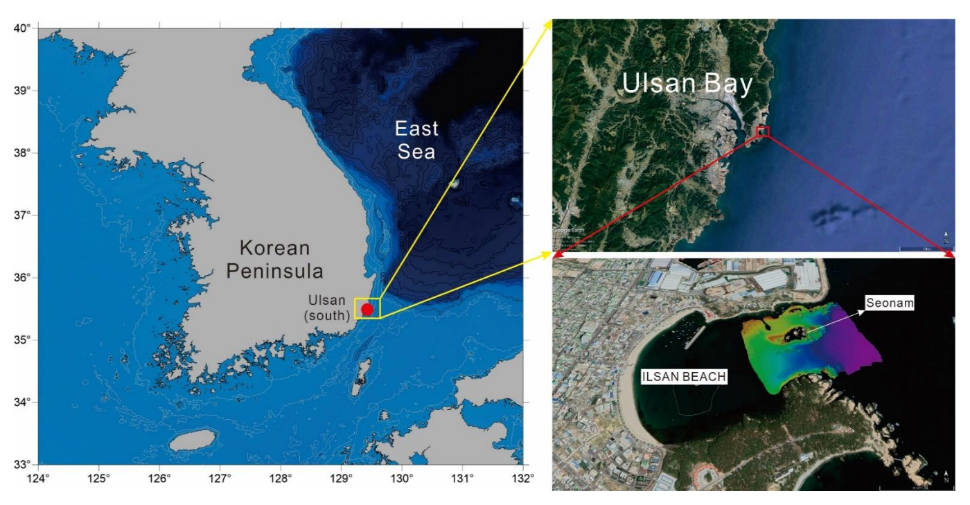
- Detailed bathymetry and seafloor image datasets, using multi-beam echo sounder and side scan sonar, around Seonam, Ilsan beach, Ulsan
- Soon Young Choi, Chang Hwan Kim, Won Hyuck Kim, Hyun-Ok Choi, Chan Hong Park, Feel Hoon Go
- GEO DATA. 2022;4(4):1-12. Published online December 31, 2022
- DOI: https://doi.org/10.22761/DJ2022.4.4.001
- 827 View
- 49 Download
-
 Abstract
 PDF
PDF - We obtained detailed bathymetry and seafloor image datasets using multi-beam echo sounder and side scan sonar around Seonam at Ilsan beach in Ulsan. The survey was conducted from May 9 to May 12, 2018, using a small vessel. The equipment used for the survey was R2Sonic's Sonic 2020 (Multi-beam Echo Sounder) and EdgeTech’s 4125 (Side Scan Sonar). The detailed bathymetry of the study area shows slightly different topographical features for each part around Seonam. The eastern and southern parts have steep slopes and the depth of the water in the areas deepens away from the surroundings of the submerged bedrock area adjacent to Seonam. The water depth in the western and northern part is shallower with a relatively gentle slope, compared to the eastern and southern parts. The rocky bottom zones are mainly distributed in the eastern part area with the water depth range of 3 to 9 m around the Seonam. Some rocky areas also appear in the western region. Seafloor backscatter image shows irregular, complex reflection patterns of acoustic intensity mainly in the eastern and western adjacent areas around Seonam, and in the northern and southern coastal waters, which are almost identical to the underwater rock zones with shallow water depth. The detailed bathymetry and seafloor image datasets around Seonam, using the multi-beam echo sounder and the side scan sonar, can be used as an essential data for environment habitat mapping.
- Kompsat-5 Image Data Provision and Quality Management
- Dochul Ynag, Horyung Jeong, Doochun Seo
- GEO DATA. 2022;4(4):13-19. Published online December 31, 2022
- DOI: https://doi.org/10.22761/DJ2022.4.4.002

- 571 View
- 42 Download
-
Abstract
PDF
- The Korea Aerospace Research Institute is conducting continuous quality management to provide reliable Kompsat-5 SAR image products to users. In this paper, the Kompsat-5 satellite operation, data processing, quality management, and data provision were described. The operation and image mode characteristics of the Kompsat-5 satellite from the image point of view were described, and the classification and characteristics of image products provided to users were explained. In addition, image data acquisition, quality index measurement, and its results are described for quality management of SAR images. Finally, it explains how to search for and order Kompsat image product through the ARIRANG system to quickly provide users with image products whose quality has been confirmed through quality management. Kompsat product can be searched and ordered from the ARIRANG Satellite Search and Order System (https://ksatdb.kari.re.kr/arirang/).
- Distribution characteristics of invasive alien amphibians and reptiles in Korean
- HeeNam Yoon, YongKi Kim, ManSeok Shin
- GEO DATA. 2022;4(4):20-27. Published online December 31, 2022
- DOI: https://doi.org/10.22761/DJ2022.4.4.003
- 951 View
- 48 Download
-
Abstract
PDF
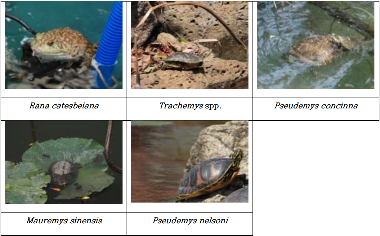
- This study analyzed the distribution and habitat status of 1 species of amphibian and 4 species in 1 genus of reptiles among “ecosystem-disturbing species” designated by the Ministry of Environment through the National Habitat Survey of Alien Species (2015-2021). As a result, Rana catesbeiana with 415 sites, Trachemys spp. with 513 sites, Pseudemys concinna with 174 sites, Pseudemys nelsoni with 66 sites, and Mauremys sinensis with 31 sites. Of the total habitat area of R. catesbeiana, the agricultural land area accounted for 46% and the used(urbanized/dry) area accounted for 15%. Of the total habitat area of T. spp, the ratio of agricultural land areas was 35%, and the ratio of used areas was 24%. These species were found to live mainly in reservoir areas with higher natural characteristics than in urbanized and dry areas. However, M. sinensis, which were introduced in early 2000 and have a small number of habitats, mainly inhabited agricultural land areas with high naturalness, with agricultural land areas accounting for 43% and used areas accounting for 29% of the total habitat area. Accordingly, a detailed study on the ecology and artificial release of the M. sinensis is needed.
- KOMPSAT Optical Image Data Provision and Quality Management
- Daesoon Park, Doocheon Seo, Heeseob Kim
- GEO DATA. 2022;4(4):28-38. Published online December 31, 2022
- DOI: https://doi.org/10.22761/DJ2022.4.4.004
- 402 View
- 24 Download
-
Abstract
PDF
- Korea Aerospace Research Institute (KARI) is conducting continuous quality control to provide reliable optical image products to various users. This paper describes KOrea Multi-Purpose SATellites (KOMPSAT-3 and KOMPSAT-3A) characteristics, operation, and image collection mode in order to enhance satellite image application. Also, image product of the satellites and quality management of the image product are described in this paper. The KOMPSAT-3 launched in 2012 and KOMPSAT-3A launched in 2015 collected many imageries around the world and provide them to users through web. Users can search for images through web catalog and order new imaging task. The KOMPSAT images provided under the KARI control is expected to be great help for earth observation and satellite image application enhancement.
- GEO-KOMPSAT-2A/2B AMI/GOCI-II/GEMS Data & Products
- Sungsik Huh, Kyoung-Wook Jin
- GEO DATA. 2022;4(4):39-49. Published online December 31, 2022
- DOI: https://doi.org/10.22761/DJ2022.4.4.005
- 529 View
- 28 Download
-
Abstract
PDF
- Two geostationary satellites developed by the Korea Aerospace Research Institute and currently in operation are the GEO-KOMPSAT-2A (GK-2A) and the GEO-KOMPSAT-2B (GK-2B). The main instruments mounted on these satellites are the Advanced Meteorological Imager (AMI), the Geostationary Ocean Color Imager (GOCI-II) and the Geostationary Environment Monitoring Spectrometer (GEMS). This paper briefly introduced the GK-2A and GK-2B programs including measurement principles and elements of the instruments. Moreover, the data formats, operational products, and applications are summarized.
 First
First Prev
Prev


Editorial Office of GEO DATA

#816, 8-13, Gwangpyeong-ro 56-gil, Gangnam-gu, 06367 Seoul, South Korea
Tel: +82-2-6677-5682 E-mail: geodata@gaidas.org
Corporate registration number: 780-82-00418