
Articles
- Page Path
- HOME > GEO DATA > Volume 5(4); 2023 > Article
-
Original Paper
원격탐사 기술을 이용한 세종특별자치시 금남면 금병산 일대 교목 군집 연구(2020-2021년) -
김기현1
 , 송의근2, 이정현3, 김남신4,*
 - Research of Cluster of Trees in Mt. Geumbyeong, Sejong-si Using Remote Exploration Technology(2020-2021)
-
Kihyun Kim1, Euigeun Song2, Jung-Hyun Lee3, Nam-Shin Kim4,*
-
GEO DATA 2023;5(4):347-354.
DOI: https://doi.org/10.22761/GD.2023.0045
Published online: December 27, 2023
1연구원, 국립생태원, 충청남도 서천군 마서면 금강로 1210, 33657, 대한민국
2전임연구원, 국립생태원, 충청남도 서천군 마서면 금강로 1210, 33657, 대한민국
3공동대표, 생태ICT연구소, 전라북도 군산시 내정로 27, 54042, 대한민국
4책임연구원, 국립생태원, 충청남도 서천군 마서면 금강로 1210, 33657, 대한민국
1Researcher, National Institute of Ecology, 1210 Geumgang-ro, Maseo-myeon, Seocheon-gun, 33657 Chungcheongnam-do, South Korea
2Associate Researcher, National Institute of Ecology, 1210 Geumgang-ro, Maseo-myeon, Seocheon-gun, 33657 Chungcheongnam-do, South Korea
3Principal Researcher, Ecological ICT Research Institute, 27 Naejeong-ro, Gunsan, 54042 Jeollabuk-do, South Korea
4Team Leader, National Institute of Ecology, 1210 Geumgang-ro, Maseo-myeon, Seocheon-gun, 33657 Chungcheongnam-do, South Korea
- Corresponding Author Nam-Shin Kim Tel: +82-41-950-5670 E-mail: geotop@nie.re.kr
Copyright © 2023 GeoAI Data Society
This is an Open Access article distributed under the terms of the Creative Commons Attribution Non-Commercial License (http://creativecommons.org/licenses/by-nc/3.0/) which permits unrestricted non-commercial use, distribution, and reproduction in any medium, provided the original work is properly cited.
- 279 Views
- 18 Download
Abstract
- Korea consists of 63% forested land, more than twice the global average (31%). Despite ongoing reforestation efforts since the initiation of erosion contron and greening project in 1973, many of the species planted during that plan were nonnative, such as Pinus rigida and Robinia pseudoacacia. The study area, Sejong City, is undergoing various development activities. Given the anticipated influx of nonnative species and the reduction of plant biodiversity, accurate survey and analysis are essential for the conservation of Sejong City. In recent years, remote sensing techniques have been utilized as an alternative to traditional vegetation surveys. Remote sensing employs hyperspectral imagery, and LiDAR, allowing for faster and more accurate data collection and analysis without direct on-site access. This study utilized remote sensing technologies, including hyperspectral imagery and LiDAR, to collect forest resource information in Mt. Geumbyeong, Sejong City. The area around Mt. Geumbyeong, is characterized by Quercus acutissima, Robinia pseudoacacia, and Pinus rigida. In total, there are 19 species, with 43,657 individual trees, an average height of 16.91 m, an average breast height diameter of 38.85 cm, and an average age of 68.99 years. The aim is to provide fundamental data for forest management, urban forestry, and restoration efforts amid various disturbances, such as development activities, in the area. Subsequent and ongoing data collection through additional surveys and environmental assessments in the vicinity would enable the analysis of species-specific growth rates, the impact of disturbance factors, forest management, and health assessments over multiple years.
- 우리나라는 국토의 63%가 산림으로 이루어져 있으며, 이는 세계 평균(31%)의 2배 이상, OECD 국가 중 4위에 해당한다. 그러나 일제시대와 한국전쟁을 보내는 약 43년간 우리나라의 산림은 상당히 훼손되었고, 이후 1973년 치산녹화계획을 시작으로 산림 복원이 진행되어 오고 있으나(Korea Forest Service, 2018), 당시 치산녹화계획으로 식재된 수종은 아까시나무, 리기다소나무 등 외래수종이었다(Kwak, 2011). 그럼에도 우리나라 산림은 생태축과 생태적 거점을 형성하고 있으며, 다양한 생물을 포함한 자연자원이 공존하는 생태계로서 우리나라를 대표하는 자연환경이다(Sung et al., 2019).
- 본 연구의 조사 대상지인 세종특별자치시는 충청권의 중심에 자리하고 있으며 동쪽은 청주시, 서쪽은 공주시, 남쪽은 대전광역시, 북쪽은 천안시가 인접해 있다. 또한, 세종시는 2021년 정부 정책에 따라 행복도시로 출범하면서 토취장 개발, 인공 포장면 확대 등 각종 개발행위가 진행되고 있다. 이에 외래수종 유입과 식물다양성 감소가 진행될 것으로 예상되어 세종특별자치시의 보전을 위해 정확한 조사와 분석이 필요하다(Sung and Kang, 2020).
- 최근 식생조사 방법의 대안으로 원격탐사 기법이 활용되고 있으며, 이는 인공위성이나 항공기 등을 통해 지표면 정보를 관측하여 분석 또는 해석하는 기법을 말한다(Hong et al., 2018). 또한 원격탐사는 관측 장치와 카메라, 초분광영상, 라이다(LiDAR) 등이 주로 사용되고 있으며, 이 기술을 이용하면 현장조사보다 빠르고 정확하게 연구 대상지에 직접 접근하지 않고 조사를 수행할 수 있다.
- 본 연구에서는 초분광영상과 라이다 등 원격탐사 기술을 이용하여 산림자원정보를 수집하였으며, 개발 행위 등 다양한 교란 요인이 있는 세종특별자치시 금남면 금병산 일대의 교목 군집을 추후 산림경영, 도시림 관리 및 복원에 있어 기초 자료로 활용하기 위해 연구를 수행하였다.
1. 서론
- 2.1 조사 지역 개요
- 본 조사는 세종특별자치시 금남면 금병산 일대를 대상으로 이루어졌다. 금병산은 금강 중류의 남쪽에 위치한 표고 374 m의 낮은 도시림으로, 북쪽에 세종특별자치시의 도심지, 서쪽에 충청남도 공주시, 남동쪽에 대전광역시 사이에 위치하고 있다. 또한 연구 대상지 일대는 개발행위 등 다양한 교란 요인으로 간섭이 많으며, 다양한 교목이 군락의 형태를 나타내고 있다(Lee, 2023). 2012-2021년의 세종특별자치시의 연평균 기온은 13.27℃, 연 강수량은 1,193.8 mm이며(Sejong, 2023), 해당 조사 지역의 위치는 36° 25′ 9” E-36° 28’ 51” E, 127° 18’ 16” N-127° 20’ 46” N이며, 면적은 약 33 km2로 다음 그림과 같다(Fig. 1).
- 2.2 조사 방법
- 초분광영상은 지표의 반사파(가시광선-중적외선)를 연속적으로 촬영한 영상자료로서, 지표 대상물에서 반사되는 미세한 파장을 분석할 수 있어 지표 정보를 정밀하게 분석할 수 있다. 또한 라이다는 레이저를 발사하여 지표에서 반사되는 레이저파를 3차원 점자료로 수집한 자료로서, 식생의 수고, 상관도, 흉고직경, 식생과 비식생의 경계, 임도 구분 등 정밀한 분석에 사용한다.
- 2020년 10월 18일과 2021년 7월 2일 두 차례에 걸쳐 세종특별자치시 금남면 금병산 일대 25.12 km, 교목 19종에 대한 정보를 초분광영상과 라이다 자료로 추출하였고, 전처리 및 보정기법을 활용하여 원시 데이터를 보정하였다. 라이다 점운 자료를 통한 식물 구조 추출 알고리즘을 활용하여 수종, 수고, 흉고직경, 수령, 바이오매스, 캐노피 면적 등의 개체 정보를 구축하였으며(Lee, 2023), 검증을 위해 연구 대상지의 수종별 분광표본점을 선정하였다. 표본점의 경우 군락 단위로 분포하는 수종이 있는 지점으로 총 36개 지점을 선정하였으며, 수종이 군집한 지역을 우선적으로 추출하되 경사 방향을 고려하여 연구 대상지 전체에 고루 분포하도록 선정하여 검증하였다. 표본 검증을 통한 1차 검증 후 군집 분류를 하였다. 또한 최대 우점도이면서 점유비율이 50% 이상일 경우 순군락으로 분류하였으며, 점유비율이 50% 이하이고 차하위 우점도의 편차가 낮을 경우 ‘1순위-2순위’ 혼합식생군락으로 명명하여 정보를 구축하였다. 이후 2020년 10월 14-15일과 2021년 5월 30일에 진행한 현장 조사를 통해 주요 종들이 확인되는 대표 군락 및 여러 식생이 혼재된 지역을 무작위로 총 19개 지점을 선정하여 조사하고 검증하였다(Fig. 2).
- 따라서 본 연구에서는 항공원격탐사를 통해 획득한 초분광영상과 라이다 자료 등을 이용하여 교목을 분류하여 연구 대상지의 주요 식생 군락 경계를 추출하고 구분하였으며, 정확도를 평가하기 위해 현장조사를 실시하였다.
2. 조사 지역 개요 및 조사 방법
- 세종특별자치시 금남면 금병산 일대는 상수리나무 군락, 아까시나무 식재림, 리기다소나무 식재림이 다수 분포하며(Fig. 3), 전체 19수종, 43,657개체, 평균 수고 16.91 m, 평균 흉고직경 38.85 cm, 평균 수령 68.99년이다(Table 1). 한편, 흉고 직경을 최소 5 cm부터 최대 65 cm까지를 10 cm 간격으로 등급을 나누어 분포율을 비교한 결과, 흉고직경 4등급에서 55.34%로 가장 많은 분포율을 나타냈다(Fig. 4). 또한, 수령별 분포는 65-80년 수령의 교목이 가장 많은 것으로 나타났다(Fig. 5). 이는 연구 대상지에는 평균 흉고직경이 약 40 cm이며, 평균 수령은 약 70년인 교목이 우점하는 것임을 의미하는 것이다.
- 표본점 추출에는 군락 단위로 분포하는 수종인 굴참나무, 리기다소나무, 밤나무, 버드나무, 산벚나무, 상수리나무, 소나무, 신갈나무, 아까시나무, 오동나무, 옻나무, 일본잎갈나무, 잣나무, 졸참나무, 칠엽수, 팽나무, 편백나무, 플라타너스(양버즘나무), 피나무 군집 중 36지점을 선정하여 분석하였으며, 36개 표본점 중 실제 식생 군락과 일치하는 지점 수는 36개 지점으로 정확도 100%로 분석되었다.
- 현장조사를 통한 현존식생도 현장 검증 결과 19개 검증 지점 중 실제 일치하는 군락 지점은 18개 지점으로 확인되었으며, 불일치하는 1개 지점은 일본잎갈나무 식재림에 버드나무 개체가 일부 포함되어 함께 한 군락으로 묶여 오차가 발생한 것으로 보인다. 따라서 현장 검증을 통한 정확도는 94.74%로 분석되었다.
3. 결과
- 본 연구는 2020-2021년 세종특별자치시 금남면 금병산 일대 교목 군집을 초분광영상과 라이다 자료를 통해 수종, 수고, 흉고직경, 수령, 바이오매스, 캐노피 면적 등의 정보를 추출하였다. 또한 현장조사를 통해 수집한 자료와 초분광영상과 라이다 자료를 비교해본 결과 신뢰성 있는 수치를 도출하였다.
- 이를 통해 추후 식생조사에서 조사자가 주관적으로 군락 경계를 임의로 표기하여 실제 군락 분포 위치에 오류가 생기는 문제를 최소화하거나 조사 시 객관적인 기초자료로 활용하여 신뢰도를 높일 수 있을 것이다. 또한 접근이 어려워 현장조사가 어려운 지역이나 추가 조사를 해야 하는 지점에 대해서 직접 접근하지 않고 원격탐사를 통해 데이터를 수집한다면 보다 효율적으로 연구를 진행할 수 있을 것으로 보인다. 하지만 원격탐사를 통해 산림에 분포하는 모든 수종을 구분하는 것에는 한계가 있으며, 항공촬영 시 기상 조건 및 대기 상태에 따라 오차가 발생할 수 있다. 따라서 추후 항공촬영을 통한 원격탐사 시 기상 조건, 대기 상태, 계절, 시간대 등 다양한 요인을 고려하여 진행하면 더 신뢰성 있는 결과를 얻을 수 있을 것이다.
- 또한 세종특별자치시 금남면 금병산 일대의 교목 군집 정보는 인근 계룡산에 분포하는 소나무, 신갈나무, 졸참나무, 서어나무, 느티나무 등과 비교 분석할 수 있으며(Tho et al., 2005), 추후 산림경영, 도시림 관리 및 복원에 있어 기초자료로 활용할 수 있을 것이다. 이후 추가 조사 및 주변 환경조사를 통해 다년간의 데이터를 수집한다면 수종별 성장률, 교란 요인별 영향, 산림 관리, 건강성 평가 등이 가능할 것으로 보인다.
4. 결론 및 토의
-
Acknowledgements
- This study was conducted as a preliminary study to apply the vegetation survey technique improvement technology of the National Institute of Ecology from 2020 to 2021, and we are grateful for this.
-
Conflict of Interest
On behalf of all authors, the corresponding author states that there is no conflict of interest.
-
Funding Information
This work was supported by the Ministry of the Environment, Republic of Korea (NIE-B-2023-05).
-
Data Availability Statement
The data that support the findings of this study are openly available in [Ecobank] at http://doi.or.kr/10.22756/GEO.20230000000837.
Notes


- Hong SH., Jang MJ, Jung SW, Park SW (2018) A review on monitoring Mt. Baekdu Volcano using space-based remote sensing observations. Korean J Remote Sens 34(6):1503–1517
- Korea Forest Service (2018) Forest basic planning. Korea Forest Service. https://www.forest.go.kr/kfsweb/kfi/kfs/cms/cmsView.do?mn=NKFS_02_13_01&cmsId=FC_000388 Accessed 5 Dec 2023
- Kwak JI (2011) A study on vegetation structure characteristics and ecological succession trends of Seoul urban forest, Korea. Ph.D. Thesis. University of Seoul; 316
- Lee JH (2023) A study on the mapping of physiognomic vegetation map by analysis of hyperspectral imagery and Lidar data. Ph.D. Thesis. Kongju National University; 243
- Sejong (2023) 2022 Sejong Statistical Yearbook. Sejong. https://www.sejong.go.kr/stat/fileManager/wwwbbs/576/1700211347682.pdf Accessed 5 Dec 2023
- Sung JW, Kang SG (2020) Vascular plant species in the southern Sejong. Korean J Plant Res 33(4):311–336
- Sung JW, Yoon JW, Shin HT, et al (2019) The vascular plants in Mt. Guryong, Korea. Korean J Plant Res 32(5):589–614
- Tho JH, Kim DK, Tae KH, Kim JH (2005) A study on the flora of Gyeryongsan. Korean J Plant Res 18(1):85–116
References
Appendix
Metadata for Dataset
| Sort | Field | Subcategory#1 | Subcategory#2 |
|---|---|---|---|
| Essential | *Title | Research of flora in Mt. Geumbyeong, Sejong-si (2020-2021) | |
| *DOI name | http://doi.or.kr/10.22756/GEO.20230000000837 | ||
| *Category | Biota | ||
| Abstract | In this study, using hyperspectral images and LiDAR data, we researched flora in Mt. Geumbyeong, Sejong-si, the area has a total of 19 species, 43,659 tree, an average height of 16.91 m, an average diameter at breast height of 15.30 in, and an average age of 68.99 years. | ||
| *Temporal Coverage | 2020.5.-2021.10. | ||
| *Spatial Coverage | Address | EcoBank | |
| WGS84 Coordinates | Point/Line/Polygon | ||
| 36°28’50”N 127°20’12”E | |||
| 36°25’11”N 127°20’04”E | |||
| *Personnel | Name | Kihyun Kim | |
| Affiliation | National Institute of Ecology | ||
| k717kh@nie.re.kr | |||
| *CC License | CC BY-NC | ||
| Optional | *Project | A study on enhancing habitat connectivity in the sustainable landscape | |
| *Instrument | AisaFENIX 1K: SPECIM, resolution 1.5 m, 0.396-2.4096 µm, 400 (0.0050365 µm) band | ||
| MicroCASI: ITRES, resolution 1 m, 0.405-0.997 µm, 100 (0.00592 µm) band | |||
| Lidar: TerrainMapper, resolution 0.5 cm, 4-8 data/1 m2 |
Figure & Data
References
Citations
 PubReader
 ePub Link
 Cite
Cite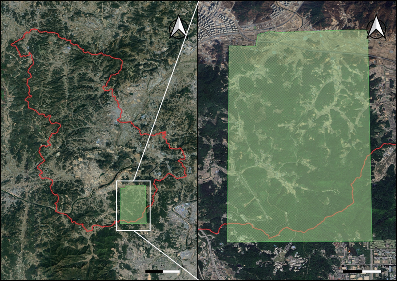


#816, 8-13, Gwangpyeong-ro 56-gil, Gangnam-gu, 06367 Seoul, South Korea
Tel: +82-2-6677-5682 E-mail: geodata@gaidas.org
Corporate registration number: 780-82-00418
