
Previous issues
- Page Path
- HOME > Articles and Issues > Previous issues
- Volume 5(4); December 2023
-


Original Papers
- GeoAI Dataset for Rural Hazardous Facilities Segmentation from KOMPSAT Ortho Mosaic Imagery
- Sung-Hyun Gong, Hyung-Sup Jung, Moung-Jin Lee, Kwang-Jae Lee, Kwan-Young Oh, Jae-Young Chang
- GEO DATA. 2023;5(4):231-237. Published online December 28, 2023
- DOI: https://doi.org/10.22761/GD.2023.0054
- 1,123 View
- 57 Download
-
 Abstract
 PDF
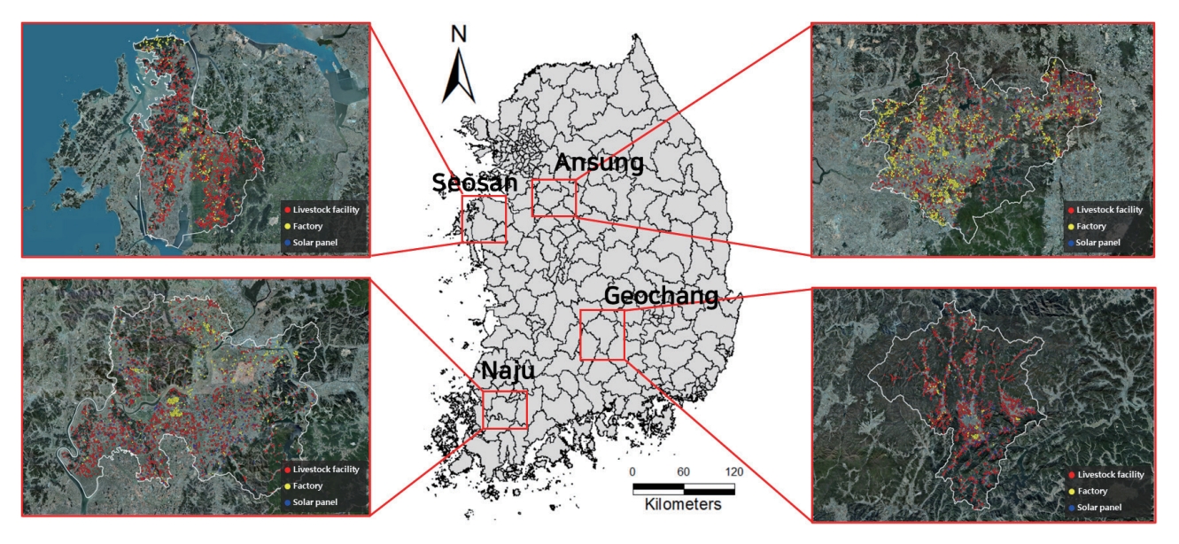
PDF - In South Korea, rural areas have been recognized for their potential as sustainable spaces for the future, but they are currently facing major problems. Unplanned construction of facilities such as factories, livestock facilities, and solar panels near residential areas is destroying the rural environment and deteriorating the quality of life of residents. Detection and monitoring of rural facilities are necessary to prevent disorderly development in rural areas and to manage rural space in a planned manner. In this study, satellite imagery data was utilized to obtain information on rural areas, which is useful for observing large areas and monitoring time series changes compared to field surveys. In this study, KOMPSAT ortho-mosaic optical imagery from 2019 and 2020 were utilized to construct AI training datasets for rural hazardous facilities segmentation for Seosan, Anseong, Naju, and Geochang areas. The dataset can be used in image segmentation models to classify rural facilities and can be used to monitor potentially hazardous facilities in rural areas. It is expected to contribute to solving rural problems by serving as the basis for rural planning.
- GeoAI Dataset for Industrial Park and Quarry Classification from KOMPSAT-3/3A Optical Satellite Imagery
- Che-Won Park, Hyung-Sup Jung, Won-Jin Lee, Kwang-Jae Lee, Kwan-Young Oh, Jae-Young Chang, Moung-jin Lee, Geun-Hyouk Han, Il-Hoon Choi
- GEO DATA. 2023;5(4):238-243. Published online December 28, 2023
- DOI: https://doi.org/10.22761/GD.2023.0052
- 501 View
- 45 Download
-
Abstract
PDF
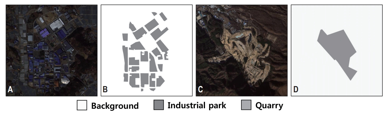
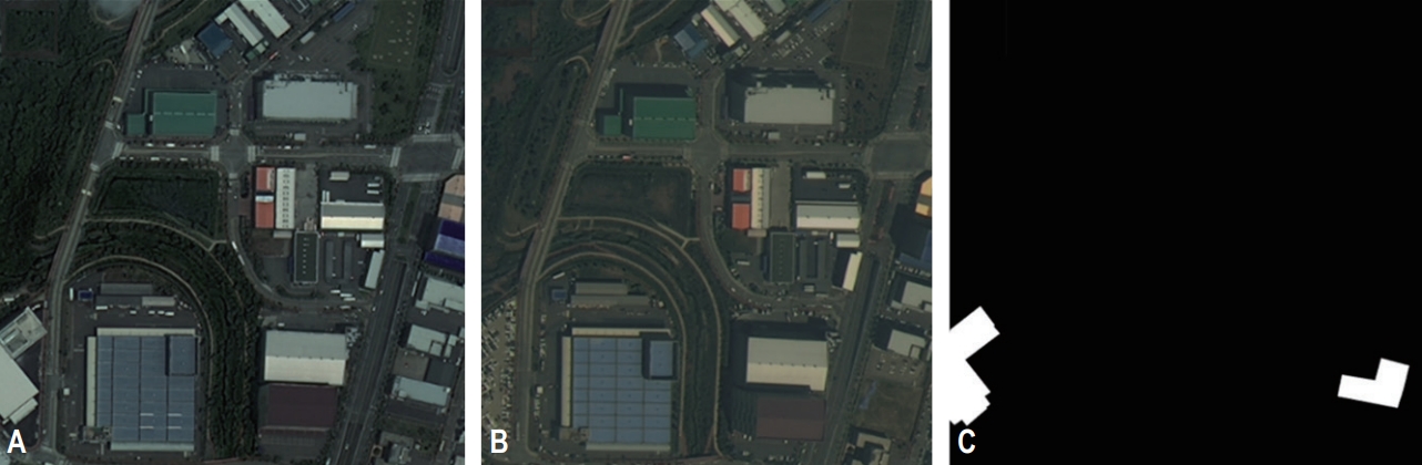
- Air pollution is a serious problem in the world, and it is necessary to monitor air pollution emission sources in other neighboring countries to respond to the problem of air pollution spreading across borders. In this study, we utilized domestic and international optical images from KOMPSAT-3/3A satellites to build an AI training dataset for classifying industrial parks and quarries, which are representative sources of air pollution emissions. The data can be used to identify the distribution of air pollution emission sources located at home and abroad along with various state-of-the-art models in the image segmentation field, and is expected to contribute to the preservation of Korea’s air environment as a basis for establishing air-related policies.
- GeoAI Dataset for Training Deep Learning-Based Optical Satellite Image Matching Model
- Jin-Woo Yu, Che-Won Park, Hyung-Sup Jung
- GEO DATA. 2023;5(4):244-250. Published online December 28, 2023
- DOI: https://doi.org/10.22761/GD.2023.0048
- 456 View
- 25 Download
-
Abstract
PDF
- Satellite imagery is being used to monitor the Earth, as it allows for the continuous provision of multi-temporal observations with consistent quality. To analyze time series remote sensing data with high accuracy, the process of image registration must be conducted beforehand. Image registration techniques are mainly divided into region-based registration and feature-based registration, and both techniques extract the same points based on the similarity of spectral characteristics and object shapes between master and slave images. In addition, recently, deep learning-based siamese neural network and convolutional neural network models have been utilized to match images. This has high performance compared to previous non-deep learning algorithms, but a very large amount of data is required to train a deep learning-based image registration model. In this study, we aim to generate a dataset for training a deep learning-based optical image registration model. To build the data, we acquired Satellite Side-Looking (S2Looking) data, an open dataset, and performed preprocessing and data augmentation on the data to create input data. After that, we added offsets to the X and Y directions between the master and slave images to create label data. The preprocessed input data and labeled data were used to build a dataset suitable for image registration. The data is expected to be useful for training deep learning-based satellite image registration models.
- The Cheonji Lake GeoAI Dataset Based in Synthetic Aperture Radar Images: TerraSAR-X, Sentinel-1 and ALOS PALSAR-2
- Eu-Ru Lee, Ha-Seong Lee, Ji-Min Lee, Sun-Cheon Park, Hyung-Sup Jung
- GEO DATA. 2023;5(4):251-261. Published online December 29, 2023
- DOI: https://doi.org/10.22761/GD.2023.0056
- 538 View
- 31 Download
-
Abstract
PDF
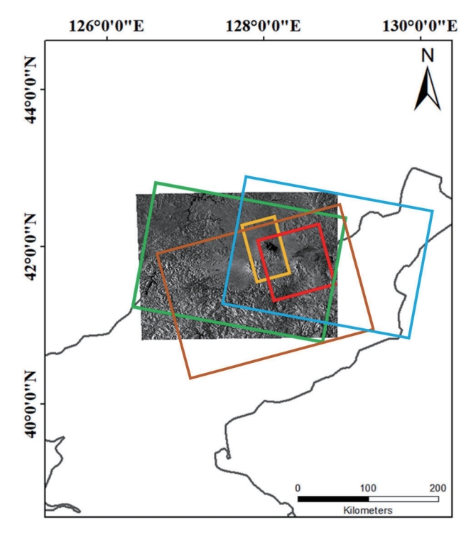
- The fluctuations in the area and level of Cheonji in Baekdu Mountain have been employed as significant indicators of volcanic activity. Monitoring these changes directly in the field is challenging because of the geographical and spatial features of Baekdu Mountain. Therefore, remote sensing technology is crucial. Synthetic aperture radar utilizes high-transmittance microwaves to directly emit and detect the backscattering from objects. This weatherproof approach allows monitoring in every climate. Additionally, it can accurately differentiate between water bodies and land based on their distinct roughness and permittivity characteristics. Therefore, satellite radar is highly suitable for monitoring the water area of Cheonji. The existing algorithms for classifying water bodies using satellite radar images are significantly impacted by speckle noise and shadows, resulting in frequent misclassification. Deep learning techniques are being utilized in algorithms to accurately compute the area and boundary of interest in an image, surpassing the capabilities of previous algorithms. This study involved the creation of an AI dataset specifically designed for detecting water bodies in Cheonji. The dataset was constructed using satellite radar images from TerraSAR-X, Sentinel-1, and ALOS-2 PALSAR-2. The primary objective was to accurately detect the area and level of water bodies. Applying the dataset of this study to deep learning techniques for ongoing monitoring of the water bodies and water levels of Cheonji is anticipated to significantly contribute to a systematic method for monitoring and forecasting volcanic activity in Baekdu Mountain.
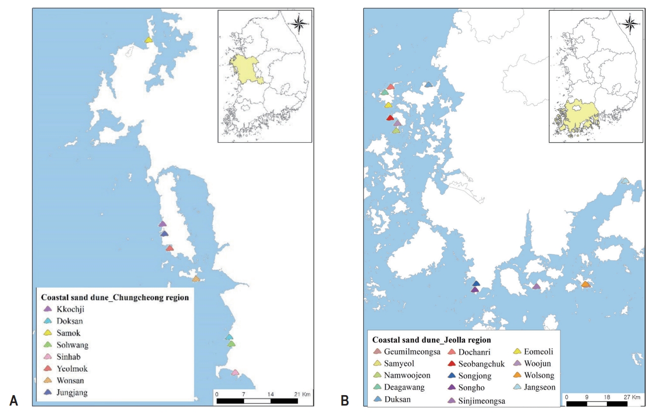
- The Study of Distribution for the Flora of Alien Species and Ecosystem Disturbing Species on Coastal Sand Dune in Chungcheong to Jeolla Region, South Korea
- Seonghun Lee, Jihyun Kang, Hyun-Su Hwang
- GEO DATA. 2023;5(4):262-272. Published online December 20, 2023
- DOI: https://doi.org/10.22761/GD.2023.0031
- 543 View
- 39 Download
-
Abstract
PDF
- This study was conducted to provide the coastal sand dunes flora of vascular plants in Chungcheong to Jeolla region based national coastal dune natural environment survey from 2018 to 2019. In the study area, a total 631 taxa, consisting of 119 family, 372 genera, 566 species, 8 subspecies, 50 varieties, and 7 forma, were found. Among them, there were 95 taxa with 23 family, 66 genera, 99 species and 5 varieties as alien species. The number of alien species ranged from 7 to 45 on each coastal sand dune. The largest number was recorded in Sinjimyeongsa dune, while the lowest was in Namujeon dune. Moreover, ecosystem disturbing species had mainly existed on Sinhap dune. Japanese hop (Humulus japonicus) were distributed most widely on 17 coastal sand dune, and bur cucumber (Sicyos angulatus) was only found on Sinhap dune. The spatial status of flora of coastal sand dune in our data can be basic ecological information for the conservation and management of the coastal dune plant species diversity.
- Investigation of Wildlife Crossing Structures in South Korea
- Euigeun Song, Sooahn Heo, Il Ryong Kim, Sehee Kim, Hanbi Lee
- GEO DATA. 2023;5(4):273-276. Published online December 22, 2023
- DOI: https://doi.org/10.22761/GD.2023.0041

- 440 View
- 35 Download
-
Abstract
PDF
- Roads, railways and infrastructure are constructed with consideration of their environmental impacts, especially habitat fragmentation. Wildlife crossing structures increase the permeability of roads and other linear infrastructures for wildlife by allowing animals to safely cross under or over roads and by reducing the risk of wildlife-vehicle collosions. We investigated the location and type of 564 wildlife crossing structures in South Korea. Between April and October 2023, we identified 365 overpasses and 199 underpasses of wildlife crossing structures respectively. Gyeonggi-do and Gyeongsangbuk-do had the largest number of wildlife crossing structures. This study can provide basic information for the effective management of wildlife crossing structures.
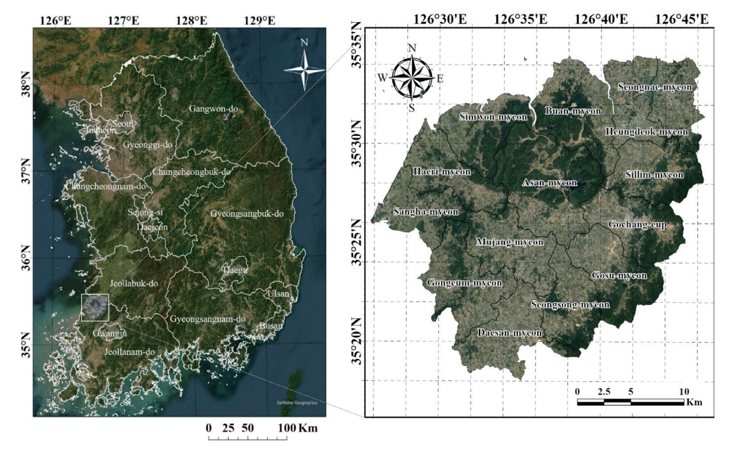
- A Study on the Development of Biotope Type and Evaluation Map of Gochang-gun
- Jeong-Cheol Kim, Chang-Hoon You, Dong-Wook Kim, WooSeok Oh
- GEO DATA. 2023;5(4):277-285. Published online December 20, 2023
- DOI: https://doi.org/10.22761/GD.2023.0034
- 502 View
- 13 Download
-
Abstract
PDF
- Gochang-gun, situated in Korea, has achieved the distinction of being the second city in the country to have all three UNESCO-designated natural environmentrelated World Heritage Sites, following in the footsteps of Jeju Island. UNESCO has conferred upon Gochang-gun the prestigious designations of a biosphere reserve, World Natural Heritage (Gochang-Buan mudflat), and World Geopark (Jeonbuk West Coast Geopark). Notably, the entire administrative district has been designated as a UNESCO Biosphere Reserve, signifying its role as a meticulously preserved region of outstanding natural beauty and ecological significance. Within this UNESCO Biosphere Reserve, the core areas encompass remarkable features, including the Gochang-Buan Mudflat, Ungok Wetland, Dolmen World Cultural Heritage sites, Seonunsan Provincial Park, and Dongrim Reservoir. In pursuit of a comprehensive ecological map of Gochang-gun, the National Institute of Ecology (NIE) conducted an extensive two-year ecological survey and biotope survey from 2021 to 2022. Ecological spatial data was meticulously compiled based on the results of these surveys. The resulting Biotope map provides detailed information on various attributes, encompassing Biotope types, Biotope grades, land cover status, land use status, and topographic details. This dataset is formally registered and rigorously managed, employing the Digital Object Identifier (DOI) system. The primary aim of this paper is to provide a comprehensive introduction to each attribute of the Gochang-gun Biotope map, which represents a detailed collection of spatial ecology data for the region. The intent is to make this data readily accessible for future research and studies, thereby advancing our understanding of Gochang-gun’s distinctive ecological and cultural heritage.
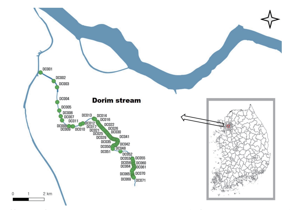
- Evaluating the Longitudinal Connectivity of Dorim Stream in Seoul based on Artificial Constructure and Fish Data
- Jeong Ho Hwang, Myeong-Hun Ko, Sungmin Jung, Jong-Hak Yun
- GEO DATA. 2023;5(4):286-297. Published online December 27, 2023
- DOI: https://doi.org/10.22761/GD.2023.0040
- 471 View
- 15 Download
-
Abstract
PDF
- The vertical connectivity of the river aquatic ecosystem was evaluated based on fish and artificial structures in Dorim stream, an urban stream in Seoul. As a result of a survey in the downstream area in 100.0 m of a total of 71 artificial structures, 13,728 individuals of fishes belonging to five orders, seven families, and 25 species were investigated, with the dominant species Zacco platypus and the subdominant species Rhynchocypris oxycephalus. As for endemic species, seven species were investigated and in terms of feeding characteristics, omnivorous species were the most common with 17 species (68%). Also an alien species, Poecilia reticulata was found. Fish species tended to decrease as the survey was conducted to upstream. Based on the movement characteristics of the fish species and the features of artificial structure survey results, the longitudinal continuity of each artificial structure was evaluated as 43 continuity, two damaged, 19 discontinuity, and seven absent. In inclined structures, stream velocity was found to be the main factor for discontinuity. In vertical structures, the down depth and head drop appeared to be the main factors for discontinuity. The results of this survey are expected to serve as basic data for the conservation of river aquatic ecosystems in the future.
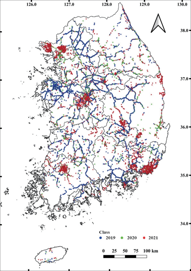
- The Integrated Dataset of Cat (Felis catus) Roadkill by Korea Roadkill Observation System
- Sooahn Heo, Il Ryong Kim, Sehee Kim, Hanbi Lee, Euigeun Song
- GEO DATA. 2023;5(4):298-303. Published online December 22, 2023
- DOI: https://doi.org/10.22761/GD.2023.0042
- 420 View
- 17 Download
-
Abstract
PDF
- The incidence of roadkill and habitat fragmentation caused by human development and road networks is on the rise. Cats primarily consume artificial food and engage in hunting near urban areas. Their numbers have an impact on the ecosystem, and cat roadkill incidents are also prevalent. In South Korea, roadkill observations are conducted by the road management agency and the Korea Roadkill Observation System. Over a 3-year period, the number of cat roadkill incidents resulted in 19,973 recorded cases, and the highest rate was in Busan Metropolitan City. Cat roadkill incidents were most prevalent during October and November. Also When analyzed at the local government level, Dangjin-si, Yangpyeong-gun, and Busan Metropolitan City exhibited the highest concentrations. This research offers essential insights for managing the cat population and mitigating cat roadkill occurrences.
- Continuous Time-Series Land Cover Maps for South Korea using Google Earth Engine
- Chulhuyn Choi, Inyoung Jang, Sanghak Han, Sungryong Kang
- GEO DATA. 2023;5(4):304-313. Published online December 20, 2023
- DOI: https://doi.org/10.22761/GD.2023.0044
- 203 View
- 14 Download
-
Abstract
PDF
 Supplementary Material
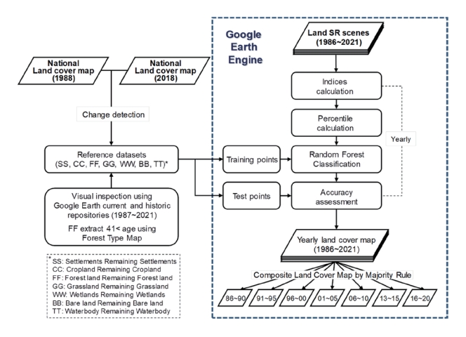
 - In this study, we utilized Google Earth Engine to construct, for the first time in South Korea, a long-term (1986-2021) continuous time series of land cover maps with a spatial resolution of 30 meters. Derived from the surface reflectance data of the Landsat satellite series, a total of 44 input variables were generated, including various spectral bands and indices related to land cover. For accuracy verification of the maps, 4,824 reference data were established using areas where land cover remained unchanged, identified by comparing the most recent (2018) and historical (1988) land cover maps from the Ministry of Environment. The Random Forest model was employed to classify seven land cover types (settlements, cropland, forest land, grassland, wetlands, bare land, and water bodies), with an overall accuracy of 0.97 and a Macro F1-score of 0.91, indicating a generally high performance of the model. However, considering the annual variability, potentially due to unidentified or untraceable errors, a composite land cover map dataset, integrated in five-year intervals, was suggested to ensure the generation of stable data.
- High-Resolution Bioclimatic Variables in Mt. Jirisan and Hallasan under Climate Change Scenario
- Sanghun Lee, Seungbum Hong, Kyungeun Lee
- GEO DATA. 2023;5(4):314-320. Published online December 20, 2023
- DOI: https://doi.org/10.22761/GD.2023.0039

- 818 View
- 101 Download
-
Abstract
PDF
- Many endemic and rare species live in Korea’s subalpine zone, but there have been many research results showing that alpine creatures are disappearing due to recent climate change. Therefore, in this study, bioclimatic variables with 100 m resolution were created for Mt. Jirisan and Mt. Hallasan, representative mountainous regions in Korea. Nineteen high-resolution bioclimatic variables were created for the current and 4 future periods, and the generated data is believed to represent topographical characteristics well. This data is expected to be useful to predict potential habitats through species distribution modeling and the impact of climate change on organisms limited to alpine regions.
- Characteristics Citizen Participation National Ecosystem Survey Data
- Dain Kang, Gyuryeong Park, Seung Se Choi, Tae Woo Yi
- GEO DATA. 2023;5(4):321-329. Published online December 22, 2023
- DOI: https://doi.org/10.22761/GD.2023.0038
- 253 View
- 10 Download
-
Abstract
PDF
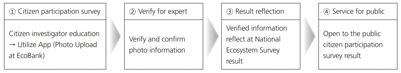
- Citizen participation data has different characteristics from expert. Understanding the unique attributes of citizen participation data and considering the disparities between such data and that collected by experts is of paramount importance to harness citizen-generated data effectively. In this regard, location information was presented for five taxa of plants, insects, birds, amphibians, and mammals nationwide surveyed by citizens in 2022, excluding endangered species. Additionally, species information and administrative district information are included. It is anticipated that the integration of citizen participation survey results with expert research findings will enhance the efficacy of natural ecological monitoring. By directly collecting ecological data, which becomes the basic data for natural environment policy, opportunities for public participation in natural environment policy will be expanded, and through this, it will be possible to raise awareness of natural environment conservation.
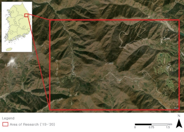
- Research on Tree Distribution in the Mt. Hambeak Area of Taebaek City Using Hyperspectral Image-LiDAR in 2019-2020
- Seung Won Lee, Junghyun Lee, Nam-Shin Kim
- GEO DATA. 2023;5(4):330-338. Published online December 27, 2023
- DOI: https://doi.org/10.22761/GD.2023.0046
- 191 View
- 19 Download
-
Abstract
PDF
- This research was conducted to improve the vegetation survey method using hyperspectral imaging and LiDAR techniques. Using Ocean FX, spectral data of seven representative species of Mount Hambaek were acquired, and hyperspectral image data of Mount Hambaek were acquired using AisaFENIX 1K and microCASI-1920 sensors. For spectral data and hyperspectral image data, tree species data were extracted using the Spectral Angle Mapper (SAM) technique, and data such as tree species location, height, and diameter at breast height were extracted through LiDAR data. the results of an investigation A total of 39,351 trees were surveyed in the Mount Hambuk area, with 25,930 trees (65.9%) in Quercus mongolica, followed by Larix kaempferi with 6,805 trees (17.3%), Alnus sibirica with 3,625 trees (9.2%), Pinus dendiflora 1,764 trees (4.5%), Pinus koraiensis 605 trees (1.5%), Pinus rigida 405 trees (1.0%), and Betulaermanii 217 trees (0.5%), As a result of selecting 28 representative colonies to be surveyed and conducting on-site verification, 27 out of 28 colonies were found to be 96.43% accurate.
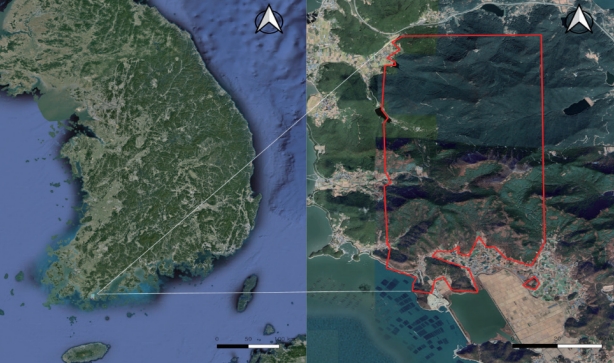
- Research on the Vegetation Distribution around Wando Arboretum using Aerial Hyperspectral Imaging-Lidar
- Dukyeop Kim, Junghyun Lee, Nam-Shin Kim
- GEO DATA. 2023;5(4):339-346. Published online December 27, 2023
- DOI: https://doi.org/10.22761/GD.2023.0047
- 173 View
- 15 Download
-
Abstract
PDF
- The average temperature of the Korean Peninsula over the past 30 years has risen 1.4°C compared to the early 20th century (1912-1941), exceeding the global temperature increase trend. Vegetation responds very sensitively to climate change. Changes in phenological response, such as fall fliage, fruiting time of vascular plants, and appearance of insects, have occurred. Areas around Wando Arboretum, the target area of this study, belongs to the subtropical climate zone. In this study, we aimed to provide basic data for systematic management of biological resources through out the survey of vegetation distribution in the area around Wando Arboretum where warm-temperate plants distribute, using hyperspectral imaging- LiDAR. As a result of converting the classification images of individual information using hyperspectral images and Lidar into objects by vegetation correlation, a total of 27 classifications were confirmed with 18 families, 24 species, and three varieties. In addition, a total of 29,884 individuals were identified.
- Research of Cluster of Trees in Mt. Geumbyeong, Sejong-si Using Remote Exploration Technology(2020-2021)
- Kihyun Kim, Euigeun Song, Jung-Hyun Lee, Nam-Shin Kim
- GEO DATA. 2023;5(4):347-354. Published online December 27, 2023
- DOI: https://doi.org/10.22761/GD.2023.0045
- 259 View
- 18 Download
-
Abstract
PDF
- Korea consists of 63% forested land, more than twice the global average (31%). Despite ongoing reforestation efforts since the initiation of erosion contron and greening project in 1973, many of the species planted during that plan were nonnative, such as Pinus rigida and Robinia pseudoacacia. The study area, Sejong City, is undergoing various development activities. Given the anticipated influx of nonnative species and the reduction of plant biodiversity, accurate survey and analysis are essential for the conservation of Sejong City. In recent years, remote sensing techniques have been utilized as an alternative to traditional vegetation surveys. Remote sensing employs hyperspectral imagery, and LiDAR, allowing for faster and more accurate data collection and analysis without direct on-site access. This study utilized remote sensing technologies, including hyperspectral imagery and LiDAR, to collect forest resource information in Mt. Geumbyeong, Sejong City. The area around Mt. Geumbyeong, is characterized by Quercus acutissima, Robinia pseudoacacia, and Pinus rigida. In total, there are 19 species, with 43,657 individual trees, an average height of 16.91 m, an average breast height diameter of 38.85 cm, and an average age of 68.99 years. The aim is to provide fundamental data for forest management, urban forestry, and restoration efforts amid various disturbances, such as development activities, in the area. Subsequent and ongoing data collection through additional surveys and environmental assessments in the vicinity would enable the analysis of species-specific growth rates, the impact of disturbance factors, forest management, and health assessments over multiple years.
 First
First Prev
Prev


Editorial Office of GEO DATA

#816, 8-13, Gwangpyeong-ro 56-gil, Gangnam-gu, 06367 Seoul, South Korea
Tel: +82-2-6677-5682 E-mail: geodata@gaidas.org
Corporate registration number: 780-82-00418