
Articles
- Page Path
- HOME > GEO DATA > Volume 5(4); 2023 > Article
-
Original Paper
KOMPSAT 정사모자이크영상을 활용한 농촌 위해시설 분류를 위한 GeoAI 학습용 데이터셋 -
공성현1,2
 , 정형섭3,4,5,*, 이명진6, 이광재7, 오관영8, 장재영8
 - GeoAI Dataset for Rural Hazardous Facilities Segmentation from KOMPSAT Ortho Mosaic Imagery
-
Sung-Hyun Gong1,2, Hyung-Sup Jung3,4,5,*, Moung-Jin Lee6, Kwang-Jae Lee7, Kwan-Young Oh8, Jae-Young Chang8
-
GEO DATA 2023;5(4):231-237.
DOI: https://doi.org/10.22761/GD.2023.0054
Published online: December 28, 2023
1석박통합과정생, 서울시립대학교 공간정보공학과, 서울특별시 동대문구 서울시립대로 163, 02504, 대한민국
2석박통합과정생, 서울시립대학교 스마트시티학과, 서울특별시 동대문구 서울시립대로 163, 02504, 대한민국
3교수, 서울시립대학교 공간정보공학과, 서울특별시 동대문구 서울시립대로 163, 02504, 대한민국
4교수, 서울시립대학교 스마트시티학과, 서울특별시 동대문구 서울시립대로 163, 02504, 대한민국
5방문연구원, 서던 메소디스트 대학교 지구과학과, 6425 Baoz Lane, Dallas, 75205 TX, 미국
6연구위원, 한국환경연구원 환경계획연구실, 세종특별자치시 시청대로 370, 30147, 대한민국
7책임연구원, 한국항공우주연구원 위성활용부, 대전광역시 유성구 과학로 169-84, 34133, 대한민국
8선임연구원, 한국항공우주연구원 위성활용부, 대전광역시 유성구 과학로 169-84, 34133, 대한민국
1Integrated Master and PhD Student, Department of Geoinformatics, University of Seoul, 163 Seoulsiripdae-ro, Dongdaemun-gu, 02504 Seoul, South Korea
2Integrated Master and PhD Student, Department of Smart Cities, University of Seoul, 163 Seoulsiripdae-ro, Dongdaemun-gu, 02504 Seoul, South Korea
3Professor, Department of Geoinformatics, University of Seoul, 163 Seoulsiripdae-ro, Dongdaemun-gu, 02504 Seoul, South Korea
4Professor, Department of Smart Cities, University of Seoul, 163 Seoulsiripdae-ro, Dongdaemun-gu, 02504 Seoul, South Korea
5Hamilton Visiting Fellow, Department of Earth Sciences, Southern Methodist University, 6425 Boaz Lane, Dallas, 75205 TX, USA
6Senior Research Fellow, Division for Environmental Planning, Korea Environment Institute, 370 Sicheong-daero, 30147 Sejong, South Korea
7Principal Researcher, Satellite Application Center, Korea Aerospace Research Institute, 169-84 Gwahak-ro, Yuseong-gu, 34133 Daejeon, South Korea
8Senior Researcher, Satellite Application Center, Korea Aerospace Research Institute, 169-84 Gwahak-ro, Yuseong-gu, 34133 Daejeon, South Korea
- Corresponding Author Hyung-Sup Jung Tel: +82-2-6490-2892 E-mail: hsjung@uos.ac.kr
Copyright © 2023 GeoAI Data Society
This is an Open Access article distributed under the terms of the Creative Commons Attribution Non-Commercial License (http://creativecommons.org/licenses/by-nc/3.0/) which permits unrestricted non-commercial use, distribution, and reproduction in any medium, provided the original work is properly cited.
- 1,044 Views
- 54 Download
Abstract
- In South Korea, rural areas have been recognized for their potential as sustainable spaces for the future, but they are currently facing major problems. Unplanned construction of facilities such as factories, livestock facilities, and solar panels near residential areas is destroying the rural environment and deteriorating the quality of life of residents. Detection and monitoring of rural facilities are necessary to prevent disorderly development in rural areas and to manage rural space in a planned manner. In this study, satellite imagery data was utilized to obtain information on rural areas, which is useful for observing large areas and monitoring time series changes compared to field surveys. In this study, KOMPSAT ortho-mosaic optical imagery from 2019 and 2020 were utilized to construct AI training datasets for rural hazardous facilities segmentation for Seosan, Anseong, Naju, and Geochang areas. The dataset can be used in image segmentation models to classify rural facilities and can be used to monitor potentially hazardous facilities in rural areas. It is expected to contribute to solving rural problems by serving as the basis for rural planning.
- 한국에서 국토 면적의 90%에 달하는 영역을 차지하는 농촌은 식량생산 이외에도 수자원의 형성과 함양, 대기 정화, 생태계 유지, 야생동물 서식처 제공 등 여러 가지 기능을 하며 그 중요성과 가치는 증대되고 있다. 하지만 공장, 축사시설, 태양광 패널 등 주민생활에 좋지 않은 영향을 미치는 시설이 주거지 인근에 무분별하게 들어서면서 농촌환경과 경관이 훼손되고, 이는 인구 감소와 주민들의 삶의 질의 저하로 이어지고 있다(Seong, 2020). 농촌의 기능회복과 농촌 주민들의 삶의 질 회복을 위해서 체계적인 공간 계획과 정책이 필요한 상황이며 이를 위해서는 농촌시설에 대한 관리 및 모니터링이 필요하다(Han and Min, 2022). 이에 따라 본 연구에서는 2023년 농촌공간정비사업 시행지침에서 유해시설로 다룬 축사, 공장, 태양광 패널 객체를 분류 대상으로 설정하였다.
- 현재 농촌 지역의 시설 등에 대한 공간정보자료는 여러 공공기관과 개별기관을 통해 현장조사 등의 방법을 통해 수집 및 구축이 진행되고 있다. 그러나 농촌은 면적이 매우 넓고 접근하기 힘든 지역이 존재하기 때문에 현장조사를 통한 자료의 수집에는 한계가 존재한다. 넓은 지역에 대한 정보를 얻을 수 있고 주기적인 획득이 가능한 위성영상 자료를 통해 잠재적인 위해시설의 효율적인 관리 및 모니터링이 가능하다.
- 인공지능 기법을 적용한 이미지 기반 딥러닝 기술은 최근 객체 분류 및 탐지에서 높은 성능을 보여주었으며, 원격탐사 데이터를 최신 딥러닝 기법에 적용하는 연구가 활발히 이루어지고 있다(LeCun et al., 2015). 이에 따라 본 연구에서는 KOMPSAT 정사모자이크 광학영상 데이터를 사용하여 농촌 위해시설(축사, 공장, 태양광 패널) 분류를 위한 AI 학습용 데이터셋을 제작하였다. 또한, 이미지의 의미론적 객체분할(semantic segmentation)에서 좋은 성능을 보이는 U-Net 모델에 제작한 AI 학습용 데이터셋을 적용한 결과를 분석하였다. 적용한 결과를 토대로 딥러닝 알고리즘을 통한 농촌 위해시설의 객체 분류 및 가능성을 조사하였고 향후 농촌계획 수립에 있어 기초자료로의 활용 가능성을 확인하였다.
1. 서론
- 2.1 연구 지역
- 연구 지역은 대한민국 충청남도 서산시, 경기도 안성시, 경상남도 거창군, 전라남도 나주시로 설정하였으며 해당 지역은 공통적으로 2022년 농촌공간계획 협약 대상 지역으로 선정되었다. 농촌공간계획은 농촌지역의 난개발 문제를 억제, 정비하는 동시에 지속 가능한 농촌공간을 만들기 위한 계획 제도를 의미한다. 본 연구에서 대상 지역으로 설정한 서산시, 안성시, 나주시, 거창군은 분류 대상 객체로 설정한 축사, 공장, 태양광 패널 객체 수가 많고 전 지역에 걸쳐 고르게 분포하고 있으므로 연구 지역으로 적합하다고 판단하였다. Fig. 1은 연구 지역의 위치와 범위를 나타낸다.
- 2.2 연구 자료
- 농촌 위해시설 분류를 위한 AI 학습용 데이터셋 제작을 위해 한국항공우주연구원으로부터 KOMPSAT 정사모자이크 영상을, 한국농촌경제연구원으로부터 축사, 공장, 태양광 패널의 속성 정보를 포함하고 있는 공간정보자료를 취득하여 구축에 활용하였다. Table 1은 본 연구에 활용된 KOMPSAT 정사모자이크영상의 정보를 나타낸다. 사용된 정사모자이크 영상은 각각 2019년도와 2020년도에 제작되었으며 blue, green, red 3개의 파장대역이 사용되었고 공간 해상도는 0.7 m를 갖는다. Table 2는 본 연구에 사용된 농촌 위해시설의 공간 데이터를 나타내며 주소정보, 획득시기, 건물명 등의 속성 정보를 포함한다.
- 2.3 데이터 제작
- 농촌 위해시설 분류를 위한 AI 학습용 데이터셋은 위성 영상 데이터와 라벨데이터가 한 쌍으로 구성된다. 한국항공우주연구원으로부터 취득한 KOMPSAT 정사모자이크영상을 사용하여 축사, 공장, 태양광 패널 객체에 대한 데이터 어노테이션(annotation) 작업을 수행하였다. 본 연구에서 데이터 어노테이션 작업은 폴리곤(polygon) 형태로 수행하였으며 분류하려는 객체에 메타 데이터를 추가하여 라벨데이터로 사용하였다. 이 과정에서 분류 대상 객체(축사, 공장, 태양광 패널)의 구축 여부 판단을 위해 농촌경제연구원으로부터 취득한 농촌시설 공간 데이터를 활용하였다. 농촌시설 공간 데이터는 주소 데이터를 지리좌표로 변환하는 지오코딩(geocoding)을 통하여 포인트 데이터로 변환 후 참조 데이터로 사용하였으며 데이터의 균질성과 일반성을 확보하기 위해 상세 데이터 구축 설계서를 작성하여 제작 과정에 적용하였다.
- 축사는 가축을 사육하기 위한 우사, 돈사, 계사 등의 시설과 그 부속시설의 경계를 구획하여 제작하였다. 이 과정에서 축사 건물은 지붕과 건축물의 외벽이 명확한 부분을 구축 대상으로 설정하였고 가축 축종은 소, 돼지, 닭, 오리, 염소의 5가지로 한정하였다. 공장은 물품의 제조, 가공, 수선이나 인쇄 등의 목적에 사용할 수 있는 설비를 갖춘 장소의 경계구역 안에 있는 건축물을 분류 대상으로 지정하였으며 공장용지 안에 설치된 부대시설 중에서 건물(지붕과 외벽이 있는 부분)을 구축 대상으로 설정하였다. 태양광 패널은 산지, 농지 외의 지표면 등에 고정하여 설치된 태양광 패널을 분류 대상으로 구분하였고 건축물 옥상에 설치된 태양광 패널은 분류 대상에서 제외하였다. 모든 분류 객체에 대하여 공사 중이거나 건물이 없는 경우는 분류 대상에서 공통적으로 제외하였다. 축사, 공장, 태양광 패널의 구축 과정에서 순서대로 각각 10, 20, 30의 라벨값을 할당하여 구축을 진행하였으며 비대상지는 90의 라벨값을 할당하였다.
- 분류 대상 객체는 fine annotation 방식으로 경계를 구획하였는데 이 과정에서 벡터 형태로 데이터를 제작하였다. 벡터 데이터 형태로 제작이 완료된 라벨데이터는 래스터화(rasterize) 과정을 통해 TIFF로 변환하였다. 위성영상 데이터와 TIFF로 변환된 라벨데이터는 25%의 중복률을 고려하여 512×512 px 크기의 패치로 최종 제작하였다.
2. 본론
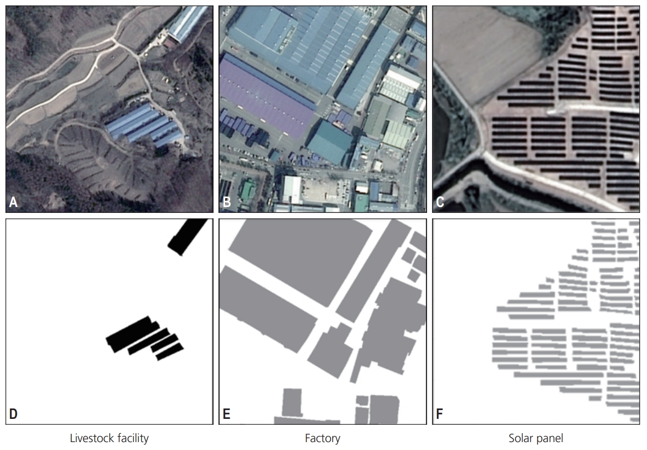
- 위의 기술한 데이터 제작 방법을 통해 2019년 데이터 7,345개의 데이터셋과 2020년 7,688개의 데이터셋을 제작하여 총 15,033개의 데이터셋을 구축하였다. Table 3은 구축된 데이터에 대한 지역별, 연도별 개수를 나타낸다. 지역별로 2019년 서산시 1,229장, 안성시 2,447장, 나주시 2,229장, 거창군 1,440장이 구축되었고 2020년 서산시 1,365장, 안성시 2,462장, 나주시 2,319장, 거창군 1,542장이 농촌 위해시설 분류를 위한 AI 학습용 데이터셋으로 구축되었다. Fig. 2는 구축된 AI 데이터셋의 예시를 나타낸다. Fig. 2A-C는 KOMPSAT 정사모자이크영상을 나타내고 Fig. 2D-F는 각각의 위성영상에 대하여 제작된 라벨 데이터를 나타낸다. Fig. 2A, D는 축사 객체를 포함하는 데이터셋, Fig. 2B, E는 공장 객체를 포함하는 데이터셋, Fig. 2C, F는 태양광 패널 객체를 포함하는 데이터셋을 나타낸다.
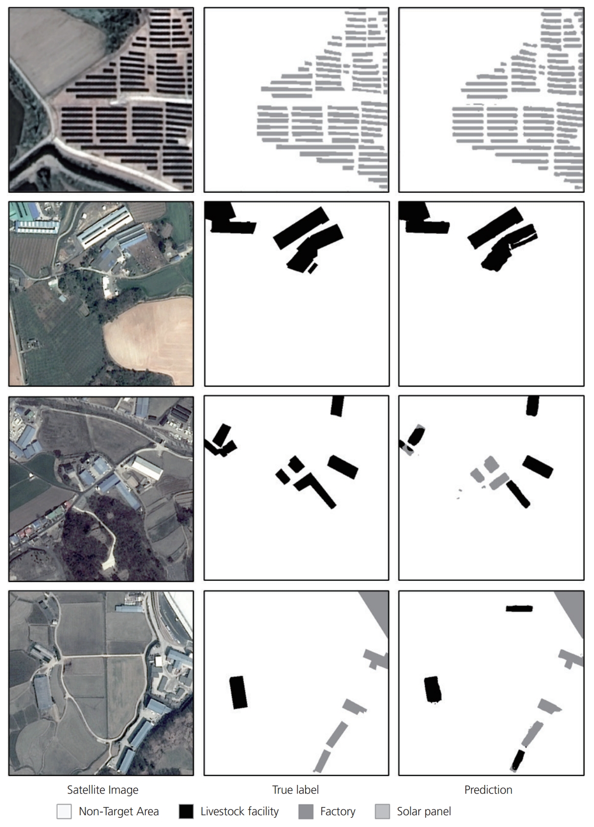
- 구축된 AI 데이터셋을 농촌 위해시설 분류를 위한 딥러닝 모델에 학습한 후 추론을 수행하였다. 농촌 위해시설 분류를 위한 딥러닝 모델은 이미지의 의미론적 분할에서 좋은 성능을 보이며 활발히 사용되고 있는 U-Net 모델을 사용하였다(Du et al., 2020; Long et al., 2015). 모델의 학습과 추론을 위하여 전체 데이터셋을 훈련용 데이터셋(80%)과 시험용 데이터셋(20%)으로 나누어 적용하였으며 훈련용 데이터셋에 대하여 데이터 확장 기법(data augmentation)을 적용하였다(Baek et al., 2022). 학습 결과 성능은 Intersection over Union이 0.7023으로 도출되었다. 각각의 분류 객체별로 F1 스코어는 축사가 0.7571, 공장이 0.8272, 태양광 패널이 0.7714의 값이 도출되었으며 공장, 태양광 패널, 축사 순으로 높은 분류 성능을 나타낸다. Fig. 3은 학습된 U-Net 모델을 사용하여 추론한 결과의 예시를 나타낸다. 추론된 결과를 확인하였을 때 패치 내부에 단일 분류 대상 객체가 존재하거나 분류 대상 객체와 혼동되는 객체가 존재하지 않는 경우 높은 분류 성능을 나타내는 것을 확인할 수 있다. 반면 패치 내부에 두 개 이상의 분류 객체가 존재하거나 분류 대상 객체와 구분하기 어려운 객체가 함께 존재할 경우 일부 오탐지 또는 미탐지되는 것을 확인할 수 있다. 오탐지되는 객체와 무관하게 건물 또는 분류 대상 객체의 경계를 매우 잘 검출하였음을 확인할 수 있다.
3. 결과
- 본 연구에서는 KOMPSAT 정사모자이크영상과 농촌 위해시설 위치 데이터를 활용하여 농촌 위해시설의 분류를 위한 AI 학습용 데이터셋을 구축하고 U-Net 모델에 적용하여 활용 가능성을 확인하였다. 본 연구에서 제작한 AI 학습용 데이터셋은 농촌 위해시설을 식별하고 관리하는 데 있어 인공지능 기반의 접근 방식의 유효성을 입증하며 농촌 지역의 지속 가능한 발전과 관리를 위한 핵심적인 자료로 활용될 수 있음을 시사한다. 또한, 향후 엄밀한 데이터 구축 기준 및 다양한 종류의 위성영상을 통한 데이터의 추가 구축을 통해 딥러닝 모델의 성능을 높일 것으로 기대되며 장기적으로는 국가적 차원의 농촌 관리 계획 수립에 기여할 수 있을 것으로 기대된다.
4. 결론
-
Conflict of Interest
On behalf of all authors, the corresponding author states that there is no conflict of interest.
-
Funding Information
This work is financially supported by Korea Ministry of Land, Infrastructure and Transport (MOLIT) as 「Innovative Talent Education Program for Smart City ('19-'23)」.
-
Data Availability Statement
The data that support the findings of this study are openly available in GEO DATA at https://doi.org/10.22761/GD.2023.0054.
Notes


| Area |
Year |
Total | |
|---|---|---|---|
| 2019 | 2020 | ||
| Seosan | 1,229 | 1,365 | 2,597 |
| Anseong | 2,447 | 2,462 | 4,909 |
| Naju | 2,229 | 2,319 | 4,548 |
| Geochang | 1,440 | 1,542 | 2,982 |
- Baek W, Lee M, Jung H (2022) Performance improvement of land cover classification U-Net model through data augmentation. Korean J Remote Sens 38(6):1663–1676
- Du G, Cao X, Liang J, et al (2020) Medical image segmentation based on U-Net: a review. J Imaging Sci Techn 64(2):020508Article
- Han IC, Min KC (2022) Chapter 3: How to prepare for rural spatial planning. In: Korea Rural Economic Institute, editors. Agricultural Outlook 2022 Korea. Korea Rural Economic Institute, Naju, p. 71–97
- LeCun Y, Bengio Y, Hinton G (2015) Deep learning. Nature 521:436ArticlePubMedPDF
- Long J, Shelhamer E, Darrell T (2015) Fully convolutional networks for semantic segmentation. In: Proceedings of the IEEE Conference on Computer Vision and Pattern Recognition, Boston; 7-12 Jun 2015Article
- Seong JI (2020) Directions and challenges in establishing rural spatial planning. In: Korea Rural Economic Institute, editors. Institutionalization of Rural Space Planning and Tasks. Korea Rural Economic Institute, Naju, p. 61–91
References
Appendix
Appendix
| Sort | Field | Subcategory#1 | Subcategory#2 |
|---|---|---|---|
| Essential | *Title | Rural hazardous facilities segmentation AI dataset | |
| *DOI name | https://doi.org/10.22761/GD.2023.0054 | ||
| *Category | Rural data | ||
| Abstract | |||
| *Temporal Coverage | 2019, 2020 | ||
| *Spatial Coverage | Seosan, Ansung, Naju, Geochang | Republic of Korea | |
| WGS84 Coordinates | |||
| *Personnel | Name | Sung-Hyun Gong | |
| Affiliation | University of Seoul | ||
| gong961107@uos.ac.kr | |||
| *CC License | CC BY | ||
| Optional | *Project | ||
| *Instrument | KOMPSAT ortho mosaic imagery |
Figure & Data
References
Citations
 PubReader
 ePub Link
 Cite
Cite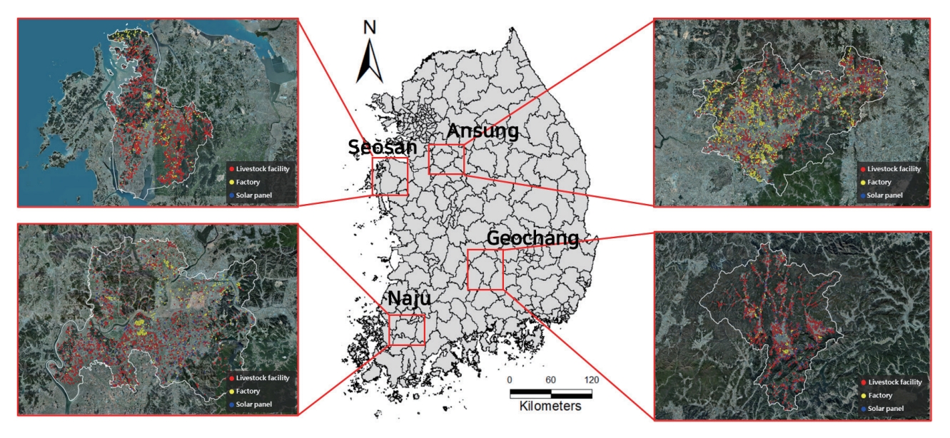


#816, 8-13, Gwangpyeong-ro 56-gil, Gangnam-gu, 06367 Seoul, South Korea
Tel: +82-2-6677-5682 E-mail: geodata@gaidas.org
Corporate registration number: 780-82-00418
