
Articles
- Page Path
- HOME > GEO DATA > Volume 5(4); 2023 > Article
-
Original Paper
생태계 환경 모니터링을 위한 정밀해저지형과 해저면 후방산란영상 데이터셋 구축: 울릉도 남부 지역 -
최순영1,2
 , 김창환1,*, 김원혁1, 박찬홍1
 - Detailed Bathymetry and Seafloor Backscatter Image Dataset for Monitoring Ecosystem Environment: Southern Ulleungdo
-
Soon Young Choi1,2, Chang Hwan Kim1,*, Won Hyuck Kim1, Chan Hong Park1
-
GEO DATA 2023;5(4):364-370.
DOI: https://doi.org/10.22761/GD.2023.0037
Published online: December 27, 2023
1연구원, 한국해양과학기술원 독도전문연구센터, 경상북도 울진군 죽변면 해양과학길 48, 36315, 대한민국
2박사과정, 강원대학교 과학교육학과, 강원특별자치도 춘천시 강원대학길 1, 24341, 대한민국
1Researcher, Dokdo Research Center, Korea Institute of Ocean Science and Technology, 48 Haeyanggwahak-gil, Jukbyeon-myeon, Uljin-gun, 36315 Gyeongsangbuk-do, South Korea
2The Doctor's Course, Division of Science Education, Kangwon National University, 1 Kangwondaehak-gil, Chuncheon, 24341 Gangwon-do, South Korea
- Corresponding Author Chang Hwan Kim Tel: +82-54-780-5340 E-mail: chkim@kiost.ac.kr
Copyright © 2023 GeoAI Data Society
This is an Open Access article distributed under the terms of the Creative Commons Attribution Non-Commercial License (http://creativecommons.org/licenses/by-nc/3.0/) which permits unrestricted non-commercial use, distribution, and reproduction in any medium, provided the original work is properly cited.
- 183 Views
- 13 Download
Abstract
- We obtained a detailed bathymetry dataset using multi-beam echo sounder around Neunggeol located at Southern part in Ulleungdo. The survey period was from September 1, 2019 and the bathymetry survey was carried out by RV Jangmok No2 of Korea Institute of Ocean Science and Technology. The instrument equipment used for the survey were Kongsbergs’s EM2040 (multi-beam echo sounder). The detailed bathymetry of the study area shows gradually depth change from about 4 to 190 m. The study area has relatively gentle slopes from the coast to 25 m and below about 125 m in depth, but a steep slope from about 25 to 125 m. The rocky bottom zones identified from detailed bathymetry and backscattered seafloor images are distributed in the northeastern sea of the coastal area, the central sea, and around Neunggeol. In particular, Neunggeol and the near large outcropping rock are tumulus-like submarine landforms, forming big vertical walls. The submarine cable buried between Ulleungdo and the Korean mainland appears in the northern seafloor of the survey area. Stopper stones and gravels sediment are distributed around it. The rocky bottom zone has a strong and irregular reflection intensity in the seafloor backscattered image and the sandy sediment zone has a relatively weak reflection intensity and a uniform pattern, so the two zones are well divided. We classified the sediment zones into fine-grained sediments, sandy sediments, and gravel-like sediments by using the different reflection intensities due to differences in sediment particle size in the seafloor image. Detailed bathymetry and seafloor backscattered image dataset around Neunggeol can be used as a basic data for habitat environment mapping.
- 동해안의 해양환경 변화에 따른 주요 해저 서식지인 사질-수중암반 분포 해역의 생태계 특성 변화를 분석하기 위하여 연속적인 해양생태계 시계열 변화 분석이 필요하다. 특히 기후 변화가 현실화된 시점에서 지구온난화로 인한 해양 시스템이 받을 영향을 정밀하게 파악하지 않는다면 추후 적절한 대응 방안 수립에 많은 어려움을 겪을 수 있다. 기후 변화로 인한 해양환경 변화는 전 지구적으로 발생하는 현상이지만 특히 인간이 인접해서 살아가는 연안 지역에 국가적 또는 지역적으로 나타나고 있다(IPCC, 2019). 특히 해수 온도 상승으로 인해 어류의 집단 폐사, 해조류 숲의 손실이 발생하는 등 기후변화의 연쇄적인 영향으로 연안 생태계 피해가 점차 확산되고 있다(IPCC, 2019). 유럽과 미국 등 여러 선진국들은 광역적 또는 지역적으로 연안 생태계 환경 모니터링을 진행 중이다(European Marine Observation and Data Network, 2023 [https://emodnet.ec.europa.eu/en]; Office for Coastal Management, 2023 [https://coast.noaa.gov/]). 국내에서는 우리나라 근해의 해양생태계의 환경과 변화를 신속하게 진단하고 평가하기 위해 국가 해양생태계 종합 조사를 실시하고 있으며 기초적인 수온, 염분, 영양염류, 엽록소, 동식물 플랑크톤 등 다양한 해양환경 정보지도를 작성하고 있다(Ministry of Oceans and Fisheries, 2023 [https://meis.go.kr/portal/main.do]). 하지만 저서생태계를 고려한 서식 환경 및 서식 생물의 종합 환경생태도 작성 및 정보 가시화는 국내에서 연구를 수행하고 있지만 아직 미흡한 실정이다(Rho et al., 2019).
- 본 연구는 연안 생태계 환경 모니터링에 필요한 서식지 환경 맵핑 주제도 분석을 위해 울릉도 남부에 해당하는 능걸 주변 지역을 선정하여 해저지형과 해저면 환경조사를 수행하였다.
1. 서론
- 2.1 조사 지역
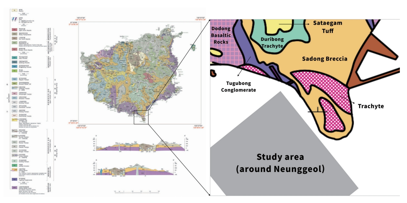
- 본 연구 지역은 울릉도 남부 능걸 주변의 약 1.4×1.4 km 해역 범위에 위치하고 있는 사질-암반 해역으로 울릉도 화산체의 급격한 경사로 인하여 연안에서 외해로 수심이 증가하면서 수심구배가 매우 큰 지역이다(Fig. 1). 연구 지역이 포함된 울릉도 남부 지역은 인접한 육지 지역이 울릉도 형성 과정에서 분출된 울릉층군으로 분류되고 있으며 신생대에 형성되어 주로 화산쇄설암류와 하부조면암류 등 화산운동 시 생성된 화산암류가 위치한 지역으로 예상된다(Fig. 2) (Hwang et al., 2012). 울릉도 해역은 동해 남부에서 올라오는 난류와 북쪽에서 내려오는 한류가 만나는 지점으로서 생물 다양성이 높은 해역으로 알려져 있다(National Institute of Biological Resources, 2021). 특히 능걸 바위는 울릉도의 대표적인 조하대 다이빙포인트(북면지역 관음도, 쌍정초, 죽도, 코끼리 바위, 서면 대풍감, 가재바위, 능걸 등) 중 하나로서 연안 생태계 환경 모니터링 지점에 적합한 지점이다.
- 2.2 자료 획득
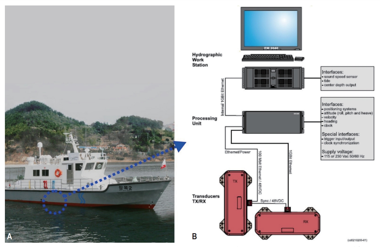
- 본 연구에서는 2019년 9월 1일에 한국해양과학기술원 연구선인 장목 2호를 이용하여 정밀해저지형조사를 수행하였다. 조사 장비는 다중빔음향측심기(multi-beam Echo sounder)인 Kongsberg사의 EM2040 (Kongsberg Co., Kongsberg, Norway)을 사용하였으며 조사 시 주사 범위는 좌우 각각 65°로 약 300 kHz 주파수 대역을 이용하여 자료를 획득하였다(Fig. 3). 해저면 후방산란영상 자료를 획득하기 위해 다중빔음향측심기에서 수심자료와 함께 추가적으로 획득 가능한 후방산란자료를 활용하였다.
- 2.3 자료 처리
- 수심자료 처리는 Teledyne사의 CARIS 프로그램(Teledyne, Fredericton, Canada)을 활용하여 후처리 및 보정하였다. 먼저 원시자료를 프로그램 내에서 변환작업을 거쳐 크게 1차 보정과 2차 보정을 수행하였다. 1차 보정은 수심자료 취득 시 측정된 빔을 제외하고 측정된 환경에 의해 영향을 미칠 수 있는 변수들(navigation/altitude, tide, sound velocity profile)을 보정하는 과정이며 2차 보정은 측정된 빔에서 오측된 자료를 직접적으로 제거하는 보정하는 과정이다. 모든 보정이 끝난 자료는 잔여 오측자료 확인 후 최종 수심자료를 추출하였다. 해저지형자료는 QPS사의 Fledermaus 프로그램(QPS, Zeist, Netherlands)을 활용하여 2차원 또는 3차원으로 구현하였으며 최종적으로 digital elevation model (DEM) (해상도 5 m)을 생성하였다. 해저면 후방산란영상자료 처리는 QPS사의 FMGT 프로그램을 활용하여 보정하였다. 원시자료 파일을 변환한 후 모자이크를 만들 때 기하학적 영상 및 밝기 왜곡을 보정하기 위한 변수를 설정한다. 이후 보정된 자료를 모자이크로 가시화 후 후방산란자료를 필터, 조정 및 주사각 범위 분석 역산 및 빔 패턴 분석 과정을 거친 뒤 최종적으로 보정된 자료를 해저면 후방산란영상도 Geotiff로 수심 해상도와 동일하게 추출하였다.
2. 본론
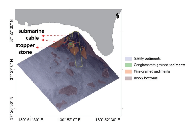
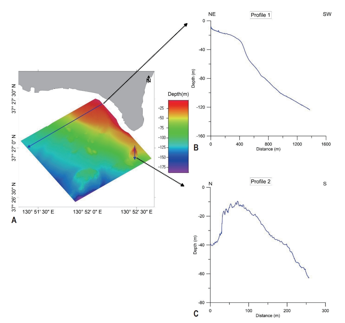
- 연구 지역에서 수행한 정밀해저지형은 수심 약 4-190 m까지 수심이 단계적으로 변화하는 지역이다(Fig. 4). 연안 지역의 경우 수심 약 25 m까지 약간 평평한 구릉지대가 존재하며 점차 수심이 깊어지며 이후 수심 약 125 m까지 경사가 조금 더 급격해지는 형태를 보인다. 한편 수심 약 125 m보다 깊은 지역은 경사가 조금 완만해진다. 조사 지역 동쪽 해역은 다이빙포인트인 능걸 바위가 존재하며 능걸 바위는 수심 약 10-50 m 범위까지 형성된 거대 직벽 지형의 형태를 가지고 있다. 능걸을 기점으로 암반의 연장 모습이 남서부방향으로 이어지고 있는 것으로 보아 이는 울릉도 화산체가 형성되면서 발생된 용암의 굳은 듯한 투물러스(tumulus) 같은 지형으로 추측된다. 투물러스는 내부에 있는 용암이 굳은 표면을 부푼 빵 모양으로 들어올려 만든 구조인 용암언덕으로서 우리나라에서는 주로 제주도와 같은 화산폭발 지역에서 나타난다(Koh et al., 2021). 조사 지역 남쪽 해역에는 능걸보다 규모가 약 2배인 거대 돌출지형이 나타나며 수심은 약 100-130 m대에 형성되어 있다. 조사 지역 중심부 해역에는 몇 개의 소규모 돌출 지형이 산재되어 있으며 북쪽 해역에는 남북방향으로 긴 띠 모양의 해저굴곡이 나타난다. 이는 울릉도와 육지 사이에 연결된 해저케이블이 매립되었을 것으로 추정된다. 정밀해저지형자료로부터 예상된 수중 암반 지대는 주로 연안 지역인 북동 해역과 조사 지역의 능걸 및 돌출지형에서 나타나며 그 외에는 주로 퇴적지대로 생각되는 지대들이 나타난다. 한편 케이블 매설 지역 주변으로 공사에 사용된 사석(stopper stone)이 집중되어 있는 암석 지대가 일부 존재한다.
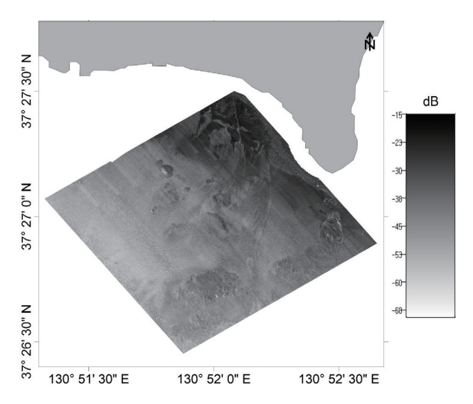
- 후방산란자료의 경우 수신기에서 발생한 빔이 반사되어 돌아온 음향신호의 강도를 영상화한 것으로서 해저 상태와 관련된 표층 퇴적물의 분포 특징, 암반의 분포 상태, 해저면 정보를 파악할 수 있다(Son, 2010). 후방산란자료로 표현한 해저면 후방산란영상에서 강하고 불규칙한 음향패턴이 나타나는 지역은 주로 조사 지역 북동해역, 능걸 지역과 그 아래 거대한 돌출지형 그리고 조사 지역 중심부 해역에 산재하고 있는 소규모 암반 지역에서 나타나며 연구 지역에 존재하는 수중암반지대와 매우 일치하는 것으로 보여진다(Figs. 5, 6). 수중암반지대를 제외한 대부분의 사질 퇴적 지대에서는 비교적 균일한 패턴의 반사강도가 나타나며 수심이 비교적 깊은 지역은 수심이 얕은 지역에 비해 약한 반사강도로 표현된다. 또한 북쪽 해역에서는 해저케이블의 형태가 해저면 후방산란영상에서도 잘 보여지며 해저케이블 주변에 있는 반사강도는 주변 지역보다 조금 더 강하게 표현되는 것으로 보아 일반 사질 퇴적물보다는 음향반사가 강한 자갈류 퇴적물 및 사석이 존재할 것으로 예상된다. 또한 해저케이블 사이에 존재하는 일부 특징적인 반사강도가 약한 지역들이 존재하는 것으로 보아 이 지역은 일반 사질 또는 자갈류 퇴적물이 아닌 얕은 언덕 형태의 세립질 퇴적층일 가능성이 높을 것으로 예상된다. 전체적인 연구 지역의 음향강도 경향성은 수중암반 및 특정 이상체들을 제외하면 주로 해역별 퇴적물 입도 분포 차이로 인한 음향강도가 나타나는 것으로 파악된다.
3. 결과
- 본 연구에서는 다중빔음향측심기 기반으로 생산한 울릉도 남부 능걸 주변 정밀해저지형 및 해저면 후방산란영상 데이터셋을 제공한다. 능걸 지역에서 생성된 정밀해저지형 및 해저면 후방산란영상 데이터셋은 향후 서식지 환경 맵핑의 기본자료로 활용 가능하며 타 분야(해양물리, 해양화학, 해양생물 등) 환경 모니터링 자료와 연계하여 조금 더 다양한 분석을 할 수 있을 것으로 사료된다.
4. 결론 및 토의
-
Conflict of Interest
On behalf of all authors, the corresponding author states that there is no conflict of interest.
-
Funding Information
This study was supported by the "Development of original technology to veritfy factors influencing barren ground on the East Sea coast accroding to climate change (PEA0016)" of Korea Institute of Ocean Science & Technology.
-
Data Availability Statement
The data that support the findings will be available in GEO DATA at https://doi.org/10.22761/GD.2023.0037 following an embargo from the date of publication to allow for commercialization of research findings.
Notes


- European Marine Observation and Data Network (EMODnet) (2023) Human Activities. EMODnet. https://www.emodnet-humanactivities.eu Accessed 9 Sep 2023
- Hwang SK, Hwang JH, Kwon CW (2012) Geological Report of the Ulleung Sheet. Korea Institute of Geoscience and Mineral Resources, Daejeon, p. 84
- IPCC (2019) IPCC Special Report on the Ocean and Cryosphere in a Changing Climate 2019 Intergovernmental Panel on Climate Change. Cambridge University Press, Cambridge and New York, p. 321–674
- Koh CS, Park WB, Koh GW, et al (2021) Estimation of the areal extent of Jeju volcanic island submerged in seawater. 2021 Joint Fall Meeting of Korean Geological Societies, RAMADA Plaza Jeju; Jeju. 26-28 Oct 2021
- Ministry of Oceans and Fisheries (2023) The Information Map of Marine Environment. Ministry of Oceans and Fisheries; https://meis.go.kr/portal/main.do Accessed 9 Sep 2023
- National Institute of Biological Resources (2021) Characteristics of biodiversity in Ulleungdo Island and Dokdo, Korea (I). National Institute of Biological Resources, Incheon, p. 57
- Son SW (2010) Acoustic backscattering measurements from two-types of bottom roughness. MS. Thesis. The Graduate School Hanyang University; 42
- Office for Coastal Management (2023) The National Coastal Zone Management Program. Office for Coastal Management; https://coast.noaa.gov Accessed 7 Sep 2023
- Rho HS, Kim CH, Kim HW, et al (2019) Eco-mapping and characterization of soft-hard bottom area in the shore of the East Sea(Eco-COAST). KIOST; https://sciwatch.kiost.ac.kr/handle/2020.kiost/36708 Accessed 9 Sep 2023
References
Appendix
Metadata for Dataset
| Sort | Field | Subcategory#1 | Subcategory#2 |
|---|---|---|---|
| Essential | *Title | XYZ | The xyz ascii dataset from multi-beam at Neunggeol area |
| Geotiff | The geotiff dataset from backscatter by multi-beam at Neunggeol area | ||
| *DOI name | https://doi.org/10.22761/GD.2023.0037 | ||
| *Category | Oceans | ||
| Abstract | XYZ | The xyz ascii dataset from multi-beam at Neunggeol area | |
| Geotiff | The geotiff dataset from backscatter by multi-beam at Neunggeol area | ||
| *Temporal Coverage | 31/August/2019 | ||
| -01/September/2019 | |||
| *Spatial Coverage | Address | Seo-myeon, Ulleung-gun, KyeongBuk | |
| WGS84 Coordinates | 130.86831612993 37.458525879113 | ||
| 130.87752460996 37.448219053762 | |||
| 130.86462757733 37.440871732129 | |||
| 130.85539206723 37.451192867618 | |||
| *Personnel | Name | Soon Young Choi | |
| Affiliation | Korea Institute of Ocean Science and Technolgy | ||
| sychoi@kiost.ac.kr | |||
| *CC License | CC BY-NC | ||
| Optional | *Project | PE99627 | ECO-mapping and Characterization Of soft-hard bottom Area in the Shore of The East Sea (Eco-COAST) |
| *Instrument | Multi-beam Echo Sounder | EM2040 (KongsbergC Co.) |
Figure & Data
References
Citations
 PubReader
 ePub Link
 Cite
Cite


#816, 8-13, Gwangpyeong-ro 56-gil, Gangnam-gu, 06367 Seoul, South Korea
Tel: +82-2-6677-5682 E-mail: geodata@gaidas.org
Corporate registration number: 780-82-00418
