
Articles
- Page Path
- HOME > GEO DATA > Volume 5(3); 2023 > Article
-
Original Paper
Synthetic Aperture Radar 인공위성 영상과 지형 자료를 활용한 하천 수변피복 분류 기계학습 알고리즘 개발 -
이재세1
 , 배덕원2, 김영준2, 임정호3,*
 - Development of Machine Learning Algorithms for Riverside Land Cover Classification Using Synthetic Aperture Radar Satellite Imagery and Terrain Data
-
Jaese Lee1, Dukwon Bae2, Young Jun Kim2, Jungho Im3,*
-
GEO DATA 2023;5(3):119-125.
DOI: https://doi.org/10.22761/GD.2023.0025
Published online: September 25, 2023
1석박통합과정, 울산과학기술원 지구환경도시건설공학과, 울산광역시 울주군 언양읍 유니스트길 50, 44919, 대한민국
2박사과정, 울산과학기술원 지구환경도시건설공학과, 울산광역시 울주군 언양읍 유니스트길 50, 44919, 대한민국
3교수, 울산과학기술원 지구환경도시건설공학과, 울산광역시 울주군 언양읍 유니스트길 50, 44919, 대한민국
1Combined Master’s-Doctoral Program, Department of Civil Urban Earth and Environmental Engineering, Ulsan National Institute of Science and Technology, 50 UNIST-gil, Eonyang-eup, Ulju-gun, 44919 Ulsan, South Korea
2Doctoral Program, Department of Civil Urban Earth and Environmental Engineering, Ulsan National Institute of Science and Technology, 50 UNIST-gil, Eonyang-eup, Ulju-gun, 44919 Ulsan, South Korea
3Professor, Department of Civil Urban Earth and Environmental Engineering, Ulsan National Institute of Science and Technology, 50 UNIST-gil, Eonyangeup, Ulju-gun, 44919 Ulsan, South Korea
- Corresponding Author Jungho Im Tel: +82-52-217-2824 E-mail: ersgis@unist.ac.kr
Copyright © 2023 GeoAI Data Society
This is an Open Access article distributed under the terms of the Creative Commons Attribution Non-Commercial License (http://creativecommons.org/licenses/by-nc/3.0/) which permits unrestricted non-commercial use, distribution, and reproduction in any medium, provided the original work is properly cited.
- 714 Views
- 68 Download
Abstract
- Riverine environments play a crucial role in maintaining the stability of river ecosystems as well as biodiversity. Furthermore, the appropriate management of small rivers has a significant impact not only on stable water supplies but also on water resource management. Wide monitoring of the riverside environment including land covers and their changes is an important issue in water resource management. This study aims to develop a high-resolution (10 m) model for classifying riverside land cover by integrating Sentinel-1 synthetic aperture radar (SAR) data and terrestrial characteristics using machine learning algorithms. We constructed a total of 3,284 landcover reference point datasets near the four major rivers of South Korea with five classes: water, barren, grass, forest, and built-up. The Random Forest and Light Gradient Boosting Machine classification models were developed using eight input variables derived from SAR signal and digital terrain data. The models showed an overall cross-validation accuracy exceeding 80% while maintaining consistent spatial distributions, except for the barren class. The false alarms on barren would be corrected through additional sampling processes and incorporating optical characteristics in further study. The high-resolution riverside land cover maps are expected to contribute to the establishment of a comprehensive management system for water resources such as riverside land cover change detection, river ecosystem monitoring, and flood hazard management. Furthermore, the utilization of the next generation medium satellite 5 (C-band SAR) would improve the performance of riverside land cover classification algorithm in the future.
- 수변 환경은 하천습지, 하중도 및 모래톱과 같은 형태로 하천 생태계의 안정성을 유지하는 중요한 역할을 하며, 특히 수변환경의 나지(하중도, 모래톱 등)는 철새와 같은 다양한 생물의 휴식처 및 서식지로 중요한 역할을 한다(Ock et al., 2020). 또한 소하천의 적절한 관리는 하류하천, 호소 및 전체 물환경의 건강성 보호(수생태계 건강성 등)와 더불어 통합유역 관리(수자원, 수질, 생물, 토지이용, 서식지 복원 등)에 매우 중요한 활용 가치를 가진다. 국내외에서 다양한 고해상도 광학 위성영상(Landsat-7/8, Sentinel-2A/B 등)을 활용하는 수변환경 모니터링 연구가 활발히 수행되고 있다(Choung, 2015; Nascimento et al., 2013; Park et al., 2016; Zhu and Woodcock, 2014). 한편, 광학 영상은 구름 및 구름 그림자로 인하여 반사도가 오염되어 가용한 자료의 양이 줄어드는 문제가 있기에 구름의 영향으로부터 비교적 자유로운 synthetic aperture radar (SAR) 영상을 식생분류 등에 활용하는 연구도 진행하고 있다(Yeom et al., 2011).
- 최근에는 SAR 영상 및 보조 자료를 결합하여 유럽 전 지역 내 토지 피복을 분류하는 연구가 진행되었으며, 2010년 기준 European Space Agency (ESA) Climate Change Initiative Land Cover 300 m 급 자료와 비교하였을 때 농경지 및 초지 영역에서 0.75 이상의 Pearson correlation coefficient 값을 보였다(Vreugdenhil et al., 2020). 유럽에 비해 우리나라와 같은 상대적으로 좁은 지역에서는 지표면의 이질적 특성을 고려한 수변피복 분석이 필요하지만, 아직까지 우리나라 내에서 SAR 자료 및 지표 특성을 반영한 수변 피복 분류 연구는 전무한 실정이다. Sentinel-1 SAR 영상을 활용한다면 12일 주기의 고해상도(10 m)의 수변환경에 대한 광역 모니터링이 가능할 것으로 기대된다. 우리나라 주요 하천 수변환경의 변화를 정량적으로 분석할 수 있으며, 수변환경의 체계적인 관리 계획 및 토지이용 계획 수립 등과 같은 의사결정에 참고 자료로 활용할 수 있을 것이다. 따라서 본 연구에서는 Sentinel-1 SAR 인공위성 영상과 지표면 특성을 고려하기 위한 지형 자료를 융합·활용하여 한반도 지역의 주요 하천에서의 10 m 급 수변피복 탐지 알고리즘 개발 및 하천수변피복의 분포에 대해서 분석을 수행하였다.
1. 서론
- 2.1 위성 및 지형 자료 수집 및 처리 방법
- Sentinel-1 위성은 C-band SAR 센서를 탑재한 ESA의 위성이다. Sentinel-1의 자료는 국내 지역을 관측하는 2019년의 자료를 모두 이용하였으며, Interferometric Wide 모드의 ground range detected (GRD) 자료 중 ascending 자료만을 이용하였다. Sentinel-1A GRD 자료는 NASA Earth Science Data Systems Program (https://search.earthdata.nasa.gov/)으로부터 취득하였다. 일반적으로 Sentinel-1 위성은 국내 지역을 12일 재방문 주기로 관측하지만, ESA의 관측 계획에 따라 관측의 시간해상도는 변경될 수 있다. 취득한 자료는 선행 연구를 참고하여(Filipponi, 2019), Sentinel Application Platform 프로그램을 이용하여 sigma naught의 vertical-vertical (VV), verticalhorizontal (VH) 편파 자료 및 incidence angle (IA) 자료를 추출하였다. 식생에 대한 민감도를 위해 VV, VH 편파 자료를 활용하여 cross ratio (CR) (Vreugdenhil et al., 2020), Radar Vegetation Index (RVI) (Kim and Van Zyl, 2009), Radar Forest Degradation Index (RFDI) (Mitchard et al., 2012)와 같은 레이더 기반 식생지수를 가용한 Sentinel-1 편파 자료에 적용하여 계산하였다. 본 연구에서 적용한 레이더 식생지수의 계산 방식은 아래 식(Eqs. 1-3)과 같다.
- 지형 자료는 수자원공사 수자원위성센터에서 제공받은 5 m 단위 격자의 전국 digital elevation model 자료를 활용하였다. 본 연구에서는 이를 10 m로 재격자화(resampling)하였으며, ArcGIS 소프트웨어를 사용하여 경사도(slope)를 계산하였다. 수변피복모델 개발을 위해 사용한 입력 자료는 아래 Table 1에 정리되어 있다.
- 2.2 수변피복 참조 자료 구축 방법 및 소개
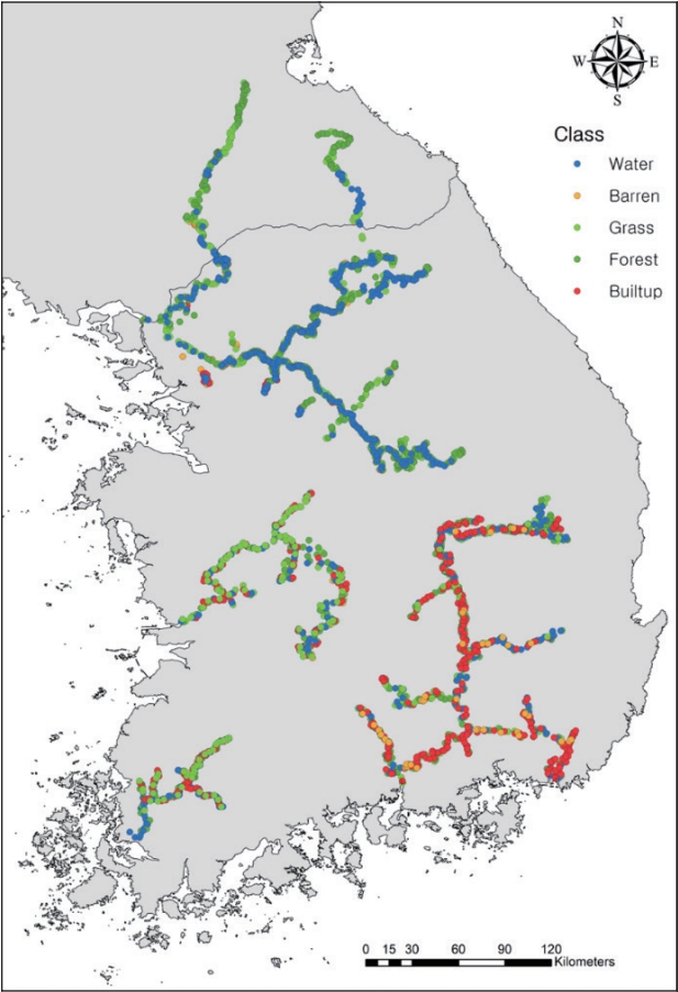
- 수변피복 분류 모델 개발을 위한 참조 자료(reference)는 2019년 Google Earth 및 Sentinel-2 광학 영상의 육안 판독을 통해 우리나라 4대 강(한강, 금강, 영산강, 낙동강) 주변 1 km 영역에서 구축되었으며, 총 3,284개 참조 자료를 본 연구에 활용하였다(Fig. 1). 분류 대상은 수체(water), 나지(barren), 초지(grass), 목지(forest), 건물(built-up)의 총 다섯 개의 클래스로 구분하였다. 보다 견고한 수변피복 탐지 모델 개발을 위하여 참조 자료 구축 시, 2019년 1년간 피복의 변화가 없고, 중심격자 주위 3×3 격자 내 동일한 피복을 가지는 픽셀을 대상으로 선정하였다.
- 2.3 인공지능 기반 수변피복 탐지 알고리즘
- 본 연구에서는 수변피복 탐지 모델로 활용하기 위한 인공지능 알고리즘으로 Random Forest (RF) 및 Light Gradient Boosting Machine (LGBM)을 이용하였다. RF는 분류 및 회귀 문제에 사용할 수 있는 앙상블 학습 알고리즘이며, 다수의 decision tree들의 과반수 투표(앙상블 평균)를 통해 최종 분류(회귀) 결과를 생성한다(Breiman, 2001). RF 알고리즘은 복원추출을 통해 임의로 선정된 훈련 데이터들을 각 트리별 훈련에 사용하여 개별 트리의 다양성을 증가시키는 방향으로 훈련되기에 자료 내 이상치에 대해 강건한 모델로 알려져 있다. RF 알고리즘의 또 다른 장점은 각 결과에 대한 개별트리 예측치의 비율을 통해 예측의 정량적인 신뢰도를 평가할 수 있는 능력이 있다. LGBM 모델은 RF와 달리 decision tree의 오차들을 순차적으로 예측하여 전체 오차를 줄이는 방식으로 훈련하는 boosting 방식의 알고리즘이다(Ke et al., 2017). LGBM은 특히 Gradient-based One-Side Sampling이라 불리는 훈련 중 전체 정보 획득량에 더 기여할 수 있는 샘플(적게 훈련된 샘플)을 보존하며 그렇지 않은 샘플을 버리는 방법 및 Exclusive Feature Bundling이라 불리는 서로 다른 특징을 가지는 변수들을 효율적으로 묶는 샘플링 방법을 추가하였으며, 그 결과로 대용량의 데이터셋에서도 높은 효율성과 성능을 나타낸 바 있다. 본 연구에서는 수변피복 탐지 알고리즘 개발을 위하여 Python 언어 내 Scikit-Learn 라이브러리의 RandomForestClassifier 함수 및 LGBM의 공식 웹사이트에서 제공하는 LGBMClassifier 함수를 사용하였다. 분류 모델의 입력변수 조합에 따른 분류 정확도 비교를 위하여 다음과 같이 총 세 가지의 변수 조합(scheme)을 사용하여 비교하였다: scheme 1 (VV + VH + IA + CR); scheme 2 (scheme 1 + RVI + RFDI); Scheme 3 (scheme 2 + elevation + slope).
- 2.4 탐지 결과 정확도 평가 방법
- 연구 결과의 정량적인 평가를 위해서 아래와 같은 방법으로 샘플을 분리하여 인공지능 알고리즘의 검증을 수행하였다. 먼저 시간적 검증은 전체 샘플 중 시간적으로 일부를 검증 자료로 사용하고 나머지를 훈련 자료로 하여 훈련 후 검증을 수행하였다. 공간적 검증은 전체 샘플 중 공간적으로 일부 참조 자료의 위치를 훈련에서 제거하여 검증 자료로 사용하였고, 시-공간적 검증은 전체 자료 중 일부를 임의로 제외하여 훈련 후 제외된 자료를 검증에 사용하였다. 분류 정확도 평가 지표는 Overall Accuracy (OA)이며 다음과 같이 계산한다(Eq. 4).
2. 연구 자료 및 방법
- 각 변수 조합 별(scheme 1-3) 수변피복 분류 결과의 정확도 비교를 위하여 훈련 자료를 시공간적(spatio-temporal), 시계열적(temporal), 공간적(spatial)으로 무작위로 8:2로 나누어 검증을 수행하였다(Fig. 2). 추가적으로 전이학습능력(transfer ability)에 대한 성능을 평가해보기 위해, 모델 내 낙동강 유역의 정보만을 학습시킨 뒤 나머지 3개 강 유역에서의 검증을 수행하였다. RF와 LGBM을 활용한 세 가지 입력변수의 조합(scheme 1-3)을 활용한 분류는 SAR 정보와 지형 정보를 함께 사용한 scheme 3에서 가장 높은 OA를 보이는 것을 확인하였다. 공간적 검증보다 시간적 검증에서의 평균 scheme 3 정확도가 높은 것을 확인하였고, 나지 클래스가 가장 낮은 분류 정확도를 보였다.
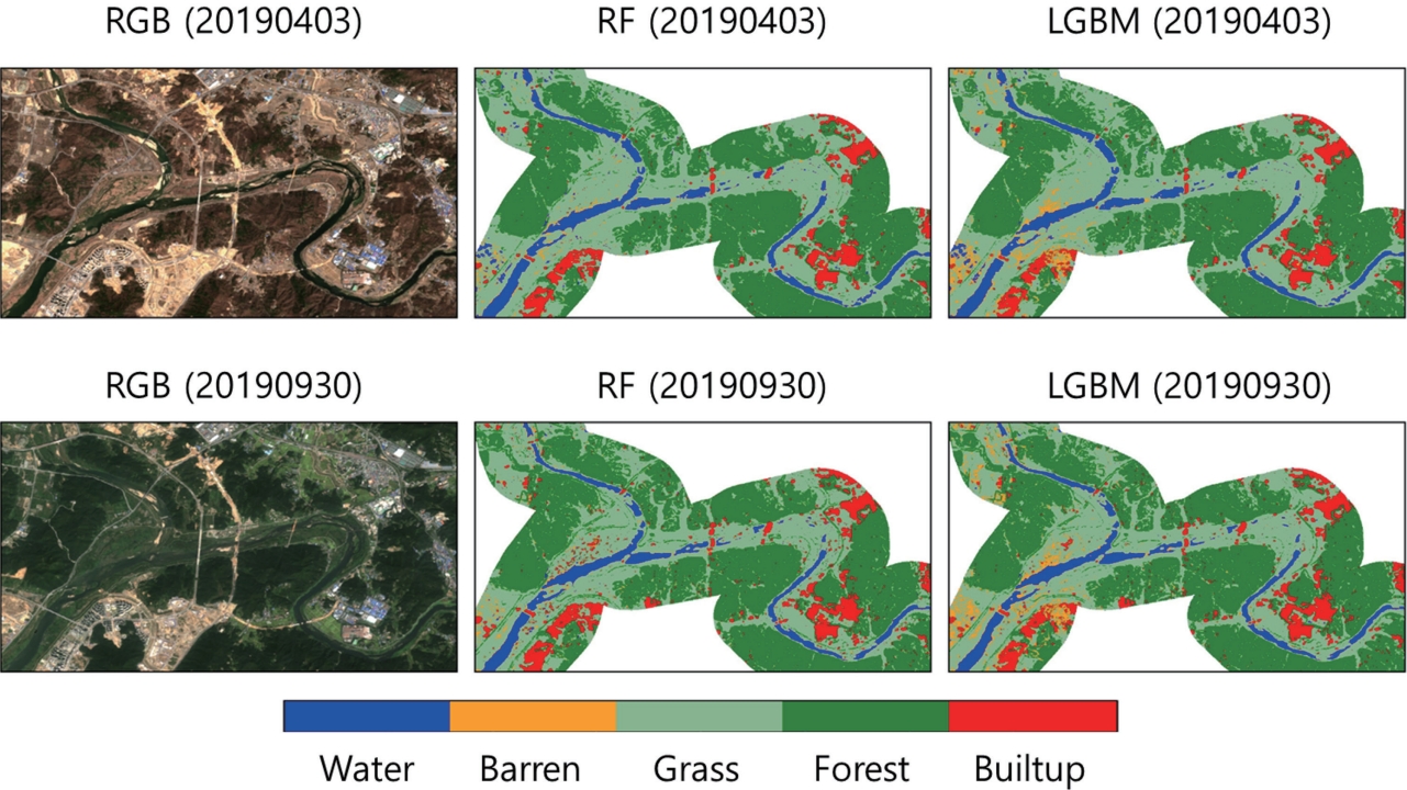
- Scheme 3 기반 분류 결과를 활용하여 금강 유역 일대에 대하여 Sentinel-2 자료의 RGB 합성 영상(10 m)과 정성적인 비교검증을 수행하였다(Fig. 3). 광학 자료와 비교 결과, 대체적으로 각 클래스별로 분류가 잘 이루어졌으나, 일부 영역(특히 수체 및 나지 픽셀)에서는 불연속적인 형태로 나타나는 것을 확인하였다.
3. 연구 결과
- Sentinel-1 SAR 영상과 지형 자료를 융합하여 우리나라 4대강 유역에 대한 10 m 급의 수변피복 분류 모델을 개발하였다. 모델 내 최적의 입력변수조합을 확인하기 위해 변수의 포함 유무에 따른 각 scheme별 비교 분석을 수행하였으며 Sentinel-1 SAR 정보만을 활용한 scheme 1, 추가적으로 식생 변수를 고려하였던 scheme 2보다 SAR 정보, 식생, 지형 정보를 모두 고려한 scheme 3에서 가장 높은 수변피복 탐지 분류 정확도를 보였다. 본 연구에서 제시하는 scheme 3는 나지 클래스를 제외하면 모두 시간, 공간, 전이능력 등 다방면에서 80% 이상의 우수한 분류 능력을 보여주었다. 또한, 본 연구에서는 사전 연구와의 직접적인 비교는 수행되지 않았으나 scheme 1과 같이 사전 연구에서 구축하였었던 단순 SAR 편파 기반 모델보다 land use/land cover 정보가 내포되어 있는 레이더 기반 식생지수, SAR 후방산란계수에 영향을 끼칠 수 있는 지형 정보를 함께 고려한 scheme 3에서 가장 높은 성능이 도출되는 것으로 미루어 볼때 보조변수 또한 상당히 영향력이 있음을 간접적으로 확인하였다. Sentinel-2 광학 영상과의 정성적 육안 비교를 통해서도 두 가지 분류 모델 모두 공간적으로 제대로 작동하는 것을 확인하였다.
- 각 변수 조합에 대한 분류 검증 결과, 공간적 검증보다 시간적 검증에서의 평균 분류 정확도가 높은 것으로 나타난 결과로 미루어 보아(Fig. 2), SAR 신호 및 지형 특성의 공간적 이질성에서 오는 오분류가 주를 이루는 것으로 판단된다. 따라서, 보다 다양한 지역적 특성을 고려한 샘플링을 통해 훈련 자료를 보완한다면 보다 정확한 분류모델을 구축할 수 있을 것으로 판단된다. 나지 클래스의 경우, 분류 정확도가 상대적으로 낮으며(Fig. 2) 광학 영상과의 정성적 비교 시, 수체와 나지의 경계가 모호하게 나타나는 경향이 있는 것으로 나타났다(Fig. 3). 이는 나지 클래스가 가지는 시계열적 변동성에서 기인한 것으로 보인다. 나지의 경우, 갈수기와 홍수기의 변화에 따라 수위 변화, 표층의 식생 변화 등 상대적으로 연중 표면 특성 변화가 크기 때문에, 모델 내 분류 정확도가 낮게 나타난 것으로 판단된다. 위에서 분석한 네 가지 검증 기법 중 시공간적 검증 결과에서 가장 높은 분류 정확도를 보인 점을 고려하면, 추가적으로 광학위성 및 드론 등을 활용한 광역적, 지속적인 관측을 통하여 보다 다양한 정보를 모델에 학습시킬 시 분류 정확도가 더 향상될 것으로 예상된다. 보다 고도화된 수체탐지 알고리즘을 적용한다면, 이와의 병합을 통하여 이러한 오탐지 영역을 개선할 수 있을 것이라 판단된다.
- 우리나라 4대강 유역의 주요 하천을 대상으로 12일 간격으로 10 m 급의 수변피복 지도와 변화 탐지에 대한 정보를 생산할 수 있을 것으로 예상되며, 이를 활용하면 보다 체계적인 통합 물관리 시스템 개발에 기여할 수 있을 것으로 기대된다. 특히, 하천 주변의 고해상도 및 짧은 재생산 주기를 활용하면 홍수기 전/후 하중도, 모래톱, 습지 등과 같은 면적의 변화에 대한 정량적인 분석이 가능 할 것으로 기대되며, 이를 통한 하천 수변 생태계 보전을 통한 생물 다양성 관리, 유속 관리 및 유로 정비, 수변 토지이용계획 수립 등 다양한 의사결정 지원에 활용할 수 있을 것으로 기대된다. 더 나아가 추후에 차세대 수자원위성을 활용한다면 본 하천 수변피복탐지, 분석 알고리즘의 고도화를 통하여 유량 관리 및 수재해 관리, 미계측 지역에 대한 확장 분석, 수재해에 취약 국가에 대한 공적개발 원조를 통한 국제협력 도모 등 다양한 활용이 가능할 것이다.
4. 결론 및 토의
-
Conflict of Interest
On behalf of all authors, the corresponding author states that there is no conflict of interest.
-
Funding Information
This research was supported by The Development of Ground Operation System for Water Resources Satellite from K-water.
-
Data Availability Statement
The data that support the findings of this study are openly available in GEO DATA at https://doi.org/10.22761/GD.2023.0025.
Notes

- Breiman L (2001) Random forests. Machine Learning 45(1):5–32
- Choung YJ (2015) Land cover change detection in the Nakdong river basin using LiDAR data and multi-temporal Landsat imagery. J Korean Assoc Geogr Inf Stud 18(2):135–148Article
- Filipponi F (2019) Sentinel-1 GRD preprocessing workflow. Proceedings 18(1):11Article
- Kim Y, Van Zyl JJ (2009) A time-series approach to estimate soil moisture using polarimetric radar data. IEEE T Geosci Remote 47(8):2519–2527Article
- Ke G, Meng Q, Finley T, et al (2017) LightGBM: a highly efficient gradient boosting decision tree. In: 31st Conference on Neural Information Processing Systems (NIPS 2017), Long Beach, 4-9 Dec 2017
- Mitchard ETA, Saatchi SS, White LJT, et al (2012) Mapping tropical forest biomass with radar and spaceborne LiDAR in Lopé National Park, Gabon: overcoming problems of high biomass and persistent cloud. Biogeosciences 9(1):179–191Article
- Nascimento WR, Souza-Filho PWM, Proisy C, Lucas RM, Rosenqvist A (2013) Mapping changes in the largest continuous Amazonian mangrove belt using object-based classification of multisensor satellite imagery. Estuar Coast Shelf S 117:83–93Article
- Ock G, Choi M, Kim JC, Park HG (2020) Temporal changes in river channel habitat diversity by large weirs in the Geum River using satellite imagery analysis. Korean J Environ Biol 38(4):705–713Article
- Park J, Lee WH, Jo M (2016) Improving accuracy of land cover classification in river basins using Landsat-8 OLI image, vegetation index, and water index. J Korean Assoc Geogr Inf Stud 19(2):98–106Article
- Vreugdenhil M, Navacchi C, Bauer-Marschallinger B, et al (2020) Sentinel-1 cross ratio and vegetation optical depth: a comparison over Europe. Remote Sens 12(20):3404Article
- Yeom J, Lee JH, Kim D, Kim Y (2011) Hierarchical land cover classification using IKONOS and AIRSAR images. Korean J Remote Sens 27(4):435–444Article
- Zhu Z, Woodcock CE (2014) Continuous change detection and classification of land cover using all available Landsat data. Remote Sens Environ 144:152–171Article
References
Appendix
Metadata for Dataset
| Sort | Field | Subcategory#1 | Subcategory#2 |
|---|---|---|---|
| Essential | *Title | Riverside land cover classification training samples | |
| *DOI name | https://doi.org/10.22761/GD.2023.0025 | ||
| *Category | imageryBaseMapsEarthCover | ||
| Abstract | A total of 3,284 training samples for riverside land cover classification | Class: 1 (water), 2 (barren), 3 (grass), 4 (forest), and 5 (built-up) | |
| *Temporal Coverage | 1 year | 2019. 01. 01. to 2019. 12. 31. | |
| *Spatial Coverage | South Korea | ||
| WGS84 Coordinates | Point | ||
| *Personnel | Name | Young Jun Kim | |
| Affiliation | Ulsan National Institute of Science and Technology | ||
| kimyj@unist.ac.kr | |||
| *CC License | CC BY-NC | ||
| Optional | *Project | ||
| *Instrument | ArcGIS 10.4.1 |
Figure & Data
References
Citations
 PubReader
 ePub Link
 Cite
Cite


#816, 8-13, Gwangpyeong-ro 56-gil, Gangnam-gu, 06367 Seoul, South Korea
Tel: +82-2-6677-5682 E-mail: geodata@gaidas.org
Corporate registration number: 780-82-00418
