
Articles
- Page Path
- HOME > GEO DATA > Volume 5(3); 2023 > Article
-
Original Paper
온실가스 지중저장 적지 탐사 데이터 구축: 지질단면도 데이터를 중심으로 -
고보균1
 , 박성재2, 이사로3,*
 - Construction of Exploration Data for Greenhouse Gas Geologic Storage: Focusing on Geological Cross-section Data
-
Bokyun Ko1, Sungjae Park2, Saro Lee3,*
-
GEO DATA 2023;5(3):222-229.
DOI: https://doi.org/10.22761/GD.2023.0023
Published online: September 26, 2023
1연구원, 강원대학교 과학교육학부, 강원특별자치도 춘천시 강원대학길 1, 24341, 대한민국
2박사과정, 강원대학교 스마트지역혁신학과, 강원특별자치도 춘천시 강원대학길 1, 24341, 대한민국
3책임연구원, 한국지질자원연구원 지질자원데이터센터, 대전광역시 유성구 과학로 124, 34132, 대한민국
1Researcher, Department of Science Education, Kangwon National University, 1 Gangwondaehak-gil, Chuncheon, 24341 Gangwon-do, South Korea
2Ph.D. Candidate, Department of Smart Regional Innovation, Kangwon National University, 1 Gangwondaehak-gil, Chuncheon, 24341 Gangwon-do, South Korea
3Principal Researcher, Korea Institute of Geoscience and Mineral Resources, 124 Gwahak-ro, Yuseong-gu, 34132 Daejeon, South Korea
- Corresponding Author Saro Lee Tel: +82-42-838-3057 E-mail: leesaro@kigam.re.kr
Copyright © 2023 GeoAI Data Society
This is an Open Access article distributed under the terms of the Creative Commons Attribution Non-Commercial License (http://creativecommons.org/licenses/by-nc/3.0/) which permits unrestricted non-commercial use, distribution, and reproduction in any medium, provided the original work is properly cited.
- 718 Views
- 66 Download
Abstract
- In this study, the most basic data, underground geological structure data, that is, geological cross-section data, were established to select a candidate site for underground storage of greenhouse gases based on AI. As a target area, the Gyeongsang Basin, where a large amount of sedimentary rocks are distributed, was selected as the greenhouse gas can be stored most effectively in sedimentary rocks. To this end, the acquisition and edit step, the refinement step, and the labeling step were carried out in the order of raw data collection, source data and labeling data construction to construct the geological cross-section data. This data can be downloaded through the AI hub site (https://aihub.or.kr/aihubdata/data/view.do?curr Menu=115&topMenu=100&aihubDataSe=realm&dataSetSn=71390) operated by the Korea Institute for Intelligent Information Society Promotion.
- 기후 변화 정부 간 협의체의 보고서는 지구 평균 온도의 상승폭을 1.5℃로 제한하려면 사회 모든 부문에서 신속하고 광범위하면서 전례 없는 변화가 필요하다고 지적하였다(Intergovernmental Panel on Climate Change, 2018). 최근 온실가스감축의 방법으로 이산화탄소 지중저장이 많은 관심을 받고 있지만 석유 자원 관련 전·후방 산업의 발달이 미약하며, 기술 시장이 미성숙된 국내의 경우 이산화탄소 지중저장소 특성화를 위한 핵심요소 기술의 조기 개발 및 자립화가 필요하며, 온실가스 지중저장의 적지 선정을 위해서는 지질도, 지질시추 데이터, 지구물리탐사 데이터, 지질단면도 데이터 등 기존에 산재되어 있는 각 지질데이터를 표준화하여 구축하고 인공지능(AI) 기술을 활용한 지하 지층의 지질구조 파악이 필수적이다. 또한 최근 AI 기술은 정확도 향상을 위한 지도학습 기반 ‘딥러닝(deep learning) 알고리즘’ 개발을 포함하여 양질의 학습을 위한 고품질의 AI 데이터셋 구축이 필수이며, 이산화탄소의 지중저장 적지 선정을 위한 근본적 해결을 위한 지하 지층의 지질구조를 AI 기반으로 분석, 지중 저장 적지 선정을 위한 AI 학습데이터 구축이 필요하다. 따라서 본 연구에서는 AI 기반으로 온실가스 지중저장 후보지 선정을 위해 가장 기본적인 데이터인 지하 지질구조 데이터, 즉 지질단면도 데이터를 구축하였다. 온실가스는 퇴적암에 가장 효과적으로 저장될 수 있으므로, 다량의 퇴적암이 분포하는 경상도 일대(경상분지; 1:50,000 축척 지질도 62장 지역; Fig. 1)를 대상 지역으로 선정하여 데이터 구축을 실시하였다.
1. 서론
- 지질단면도는 지질도에 표현된 지표의 암석 분포와 지질구조 등을 활용하여 지하의 지질 요소를 추정한 단면도로, 생성 시기와 종류가 다른 암층들 간의 상호관계, 암층들의 형태나 두께, 깊이에 따른 지질구조 변화 등이 포함된다. 지질단면도 데이터 구축을 위해 획득 및 편집을 수행하는 원시데이터 수집 단계, 수집된 데이터를 기본 지질단면도를 작성하는 원천 데이터 정제 단계, 마지막으로 구획 영역을 설정하고 어노테이션 지정 및 학습데이터를 생성하는 라벨링 단계의 3단계를 거쳐 최종 지질단면도 이미지 데이터를 구축하였다(Table 1).
- 2.1 원시데이터
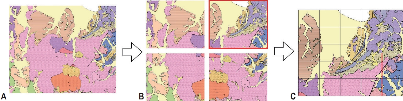
- 원시데이터는 지질단면도 이미지 데이터를 구축하기 위한 최초 자료이며, 한국지질자원연구원에서 보유한 1:50,000 축척 수치지질도이다. 원시데이터 유형은 1:50,000 축척 수치지질도를 4분할한 지질도 이미지이며, 암상, 지질경계선, 단층, 지층의 주향과 경사, 지질단면선, 광산 기호 등을 포함한 벡터 파일이다. 원시데이터 포맷은 한국지질자원연구원에서 제공하는 수치지질도의 래스터 파일(TIFF)과 벡터 파일(SHP)이다. 원시데이터 규모는 경상도 지역의 경상분지에 해당하는 1:50,000 축척 수치지질도 62개를 각각 4분할한 수치지질도 248개이다. 원시데이터는 한국지질자원연구원에서 운용 중인 지오빅데이터 오픈플랫폼(https://data.kigam.re.kr/)에서 수치지질도를 직접 다운로드하며, 부족하거나 누락된 정보가 있는 경우에는 한국지질자원연구원에 데이터를 요청하여 수집하였다. 수집된 수치지질도는 4분할하였고 각각의 분할한 지질도에 20개의 지질단면선을 작성하였다(Fig. 2).
- 2.2 원천데이터
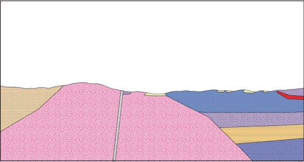
- 원천데이터는 원시데이터인 4분할 축척 수치지질도에서 불필요한 요소를 제거한 후 작성된 지질단면도이다(Fig. 3). 원천데이터 포맷은 암상의 종류와 지질경계선, 단층, 단층의 운동 방향, 습곡, 배사구조, 향사구조를 포함하는 TIFF 파일이다. 원천데이터 규모는 4분할한 지질도에서 각각 20개의 지질 단면도를 작성하였고, 따라서 1개의 1:50,000 축척 지질도에서 80개의 지질단면도를 작성하였다. 추가적으로 온실가스 지중적지로 예상되는 포항 지역의 장기분지 일대에 대하여 상대적으로 좁은 간격의 지질단면도 98개를 작성하였으며, 전체적으로 1:50,000 수치지질도 62개에서 총 5,058개의 지질단면도를 작성하였다. 각 지질단면선에 대한 지질단면도는 GIS 프로그램인 QGIS를 이용하여, 높이와 거리를 나타내는 그래프 작성 → 그래프 내부에 해당 지질단면선에 대한 지표면 작성 → 지질경계선 작성 → 각 암상에 대한 패턴(+색상) 삽입순으로 작성하였다.
- 2.3 라벨링 데이터
- 라벨링 데이터는 인공지능 학습용 이미지 데이터이며, 정제된 원천데이터의 구성 요소(암상, 암상에 대한 지질 기호, 지질 경계선, 단층, 단층의 운동 방향, 습곡, 배사구조, 향사구조)를 확인하고 구별할 수 있도록 라벨링된 이미지 데이터이다. 라벨링 데이터의 종류는 라벨링 데이터와 메타데이터로 구분되며, 라벨링 데이터의 포맷은 TIFF이고 메타데이터의 포맷은 JSON이다. 라벨링 데이터 규모는 원천데이터에 대해 라벨링을 실시한 5,058개이다(Table 2).
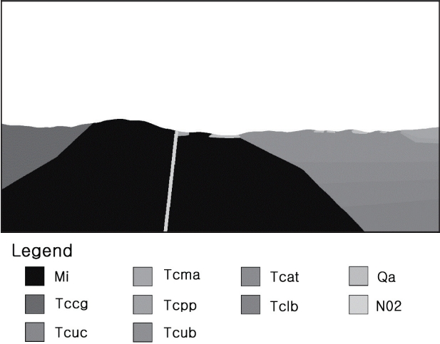
- 라벨링을 위해 정제된 원천데이터의 구성 요소(암상, 암상의 지질 기호, 지질경계선 등)를 확인하고 구별할 수 있도록 신생대 제4기 충적층, 신생대 제3기 연일층군 연일셰일, 신생대 제3기 범곡리안산암 및 응회암 등 44개 항목의 객체클래스를 설계하였고(Table 3), 이에 대한 JSON 파일 제작을 위해 메타데이터를 설정하였다(Table 4).
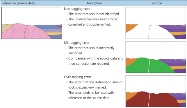
- 이러한 설계안을 바탕으로 라벨링 데이터 제작을 위해 QGIS를 활용하였으며, 지층의 지질기호, 방위, 높이와 거리에 대한 그래프 등을 제거하고, 메타데이터에 대한 JSON 파일을 작성하였다. 그리고 그래픽 편집 프로그램을 이용하여 암상 패턴을 제거하고 색상으로만 표기하였으며, 지질도를 참고하여 지질단면도를 생성하는 어노테이션 작업을 수행하였다(Fig. 4). 작성된 어노테이션 데이터는 미태깅, 오태깅, 과태깅 등의 오류 항목을 제거하는 품질 검수 과정을 거쳤다(Table 5). 품질에 이상이 없는 것으로 검수된 어노테이션 데이터는 실질적인 온실가스 지중적지 탐사를 위한 훈련 자료를 구축하기 위하여 사전에 설계된 grayscale 색상으로 변환하였다(Fig. 5).
2. 지질단면도 데이터
- 본 연구에서는 온실가스 지중저장 적지를 선정하기 위해 가장 중요하면서 기초적인 자료인 지질단면도를 경상분지 지역에 대해 구축하였다. 인공지능 학습용 지질단면도 이미지 데이터를 활용하여 효율적인 지질 조사 및 연구 수행이 가능하다. 즉, 구축된 지질단면도 이미지 데이터는 온실가스 지중저 장뿐만 아니라 지하 지질구조 파악이 필수적인 석유나 천연가스, 지하수 개발에도 적극 활용될 수 있고, 지질단면도 이미지 데이터는 효율적인 지하자원 개발을 위해 활용될 수 있다. 지하지원 개발을 위해서는 지하에 존재하는 광체의 특성을 파악하는 것이 매우 중요하며, 다량의 지질단면도 이미지 데이터는 자원 탐사 시간과 경비를 줄여 경제적이고 효과적인 자원 개발을 가능하게 한다. 본 지질단면도 데이터는 한국지능정보사회진흥원에서 운영하여 AI 허브사이트(https://aihub.or.kr/)에서 다운로드할 수 있다.
3. 결론 및 토의
-
Conflict of Interest
Saro Lee has been an Editorial Board of GEO DATA; however, he was not involved in the peer reviewer selection, evaluation, or decision process of this paper. Otherwise, no other potential conflicts of interest relevant to this paper were reported.
-
Funding Information
This work was supported by the “Construction of Artificial Intelligence Training Data; 2-93. Exploration Data of Greenhouse Gas Geologic Storage, 2022” grant funded by the National Information Society Agency and Ministry of Science and ICT. This work was also supported by Basic Research Project of the Korea Institute of Geoscience and Mineral Resources (KIGAM).
-
Data Availability Statement
The data that support the findings of this study are openly available in AI Hub at https://aihub.or.kr/, reference number. The data that support the findings of this study are available on request from the corresponding author. The data are not publicly available due to privacy or ethical restrictions.
Notes


- Intergovernmental Panel on Climate Change (IPCC) (2018) Global warming of 1.5°C. Cambridge University Press, Cambridge, 616p
References
Appendix
Figure & Data
References
Citations
 PubReader
 ePub Link
 Cite
Cite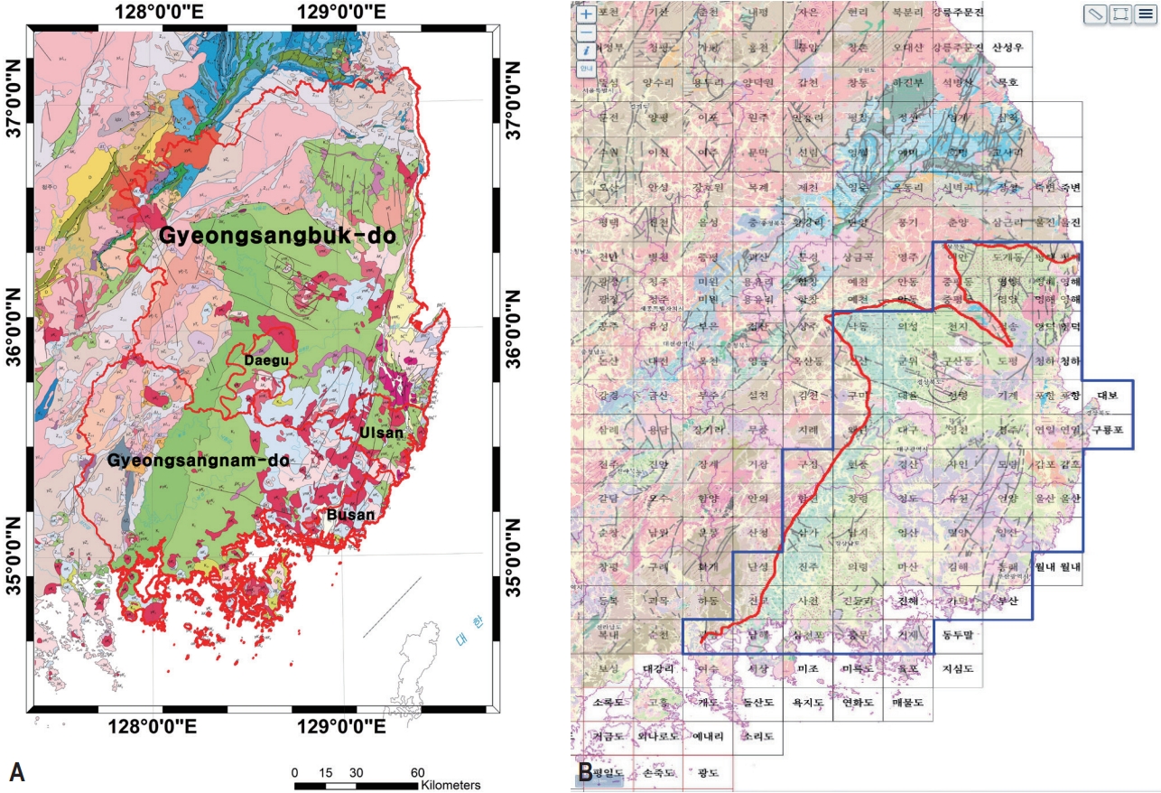


#816, 8-13, Gwangpyeong-ro 56-gil, Gangnam-gu, 06367 Seoul, South Korea
Tel: +82-2-6677-5682 E-mail: geodata@gaidas.org
Corporate registration number: 780-82-00418
