
Previous issues
- Page Path
- HOME > Articles and Issues > Previous issues
- Volume 3(1); March 2021
-


Articles
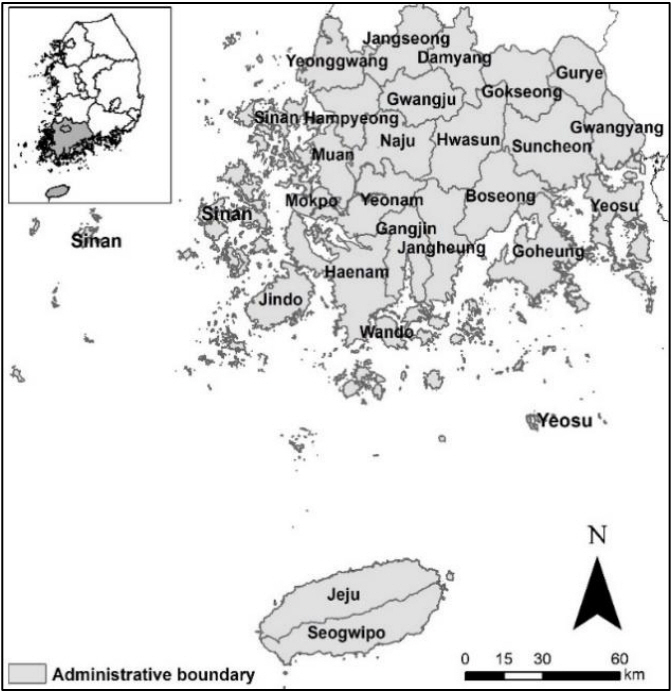
- Dataset of wild mammals distribution in the southwestern area (Jeollanam-do, Gwangju Metropolitan City and Jeju island) of Korean Peninsula
- Chi Hong Lim, Min Sik Kim, Jung Hyun Lee, Hyun Min Bum, Nam Shin Kim, Chulgoo Kim, Jin Yeol Cha
- GEO DATA. 2021;3(1):1-11. Published online March 31, 2021
- DOI: https://doi.org/10.22761/DJ2021.3.1.001
- 493 View
- 24 Download
-
 Abstract
 PDF
PDF - The results of the 4th National Ecological Survey reflect the latest status of the ecological environment in South Korea. In this study, we presented spatial data on the distribution of mammals collected through the 4th National Ecological Survey in the southwestern area of the Korean Peninsula, covering Jeollanam-do, Gwangju Metropolitan City and Jeju island. The data consists of information on mammal individuals recorded at the site and information on characteristics of abiotic environment at the recorded points, including spatial units (administrative districts, digital map index, etc.) which are necessary for statistical analysis. The data have high policy and research values because it can elaborate on the descriptive characteristics of the distribution points and identify the relationship between individual abundance and habitat environment. However, when data is utilized in a regional scale, it should precede to consider the survey system, such as how to select the survey area.
- Archive and distribution of VIIRS DNB data for the Northeast Asian Sea
- Euihyun Kim, Joo-Hyung Ryu, Suk Yoon
- GEO DATA. 2021;3(1):12-17. Published online March 31, 2021
- DOI: https://doi.org/10.22761/DJ2021.3.1.002
- 409 View
- 24 Download
- 1 Citations
-
Abstract
PDF
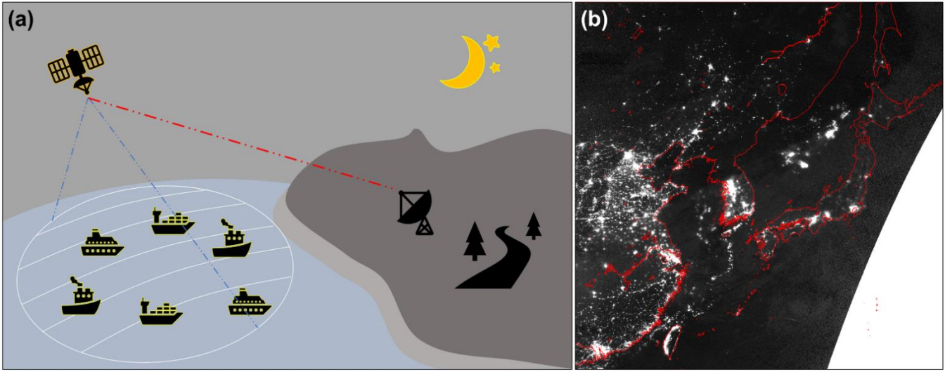
- Night-time satellite data were first collected from the U.S. Air Force in 1972 for military purposes. Since then, it has been useful to understand the human activities in the fields of society, economy, culture, and science, etc. In the perspective of oceanography, the night-time satellite data has been used for monitoring purposes such as detecting night-time fishing boats. The Korea Ocean Satellite Center (KOSC) of the Korea Institute of Ocean Science & Technology (KIOST) has been directly receiving the Suomi National Polar-orbiting Partnership (S-NPP) Visible Infrared Imaging Radiometer Suite (VIIRS) Day & Night Band (DNB) data since June 2016. It has been archived and distributed for about four years. In addition, the KOSC operates its own ground system, which pre-processing the data including the radiance transformation, conversion of coordinate system, terrain correction, and calibration of lunar irradiation effect for quality improvement. Currently, the contributed data is preprocessed within about an hour after the receiving, so it is evaluated the high efficiency and usefulness in terms of time. This has confirmed the feasibility of real-time information acquisition through the research in the field of night-time monitoring/observation missions in the Northeast Asian Sea and onshore disaster/accident monitoring. The KOSC is making efforts to utilize the distributed data in various research such as maritime domain awareness. From the second half of this year, the NOAA-20 data will be directly received and distributed as an additional night-time satellite data. In the future, it is expected that the more diverse data will be distributed through the research utilization and supports.
-
Citations
Citations to this article as recorded by
- Monitoring Maritime Ship Characteristics Using Satellite Remote Sensing Data from Different Sensors
Won-Kyung Baek, Euihyun Kim, Ho-Kun Jeon, Kwang-Jae Lee, Sang-Wan Kim, Yoon-Kyung Lee, Joo-Hyung Ryu
Ocean Science Journal.2024;[Epub] CrossRef
- Monitoring Maritime Ship Characteristics Using Satellite Remote Sensing Data from Different Sensors
- The spatial data of paddy rice classification over Northeast Asia using COMS geostationary satellite
- Seungtaek Jeong, Jonghan Ko, Jong-Min Yeom
- GEO DATA. 2021;3(1):18-22. Published online March 31, 2021
- DOI: https://doi.org/10.22761/DJ2021.3.1.003
- 462 View
- 13 Download
- 2 Citations
-
Abstract
PDF
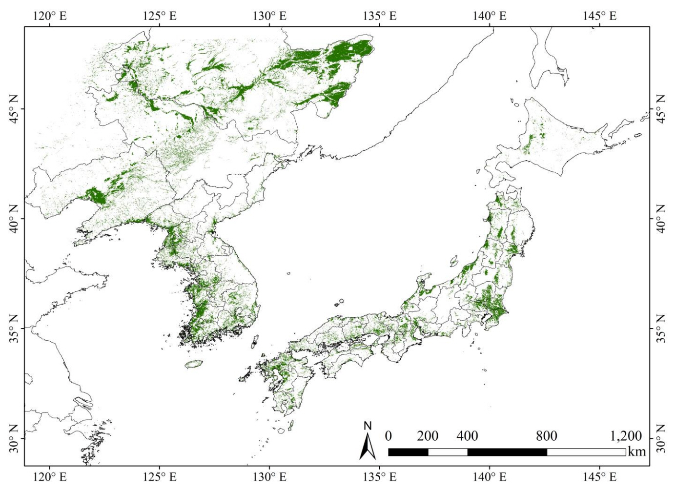
- The Korea Aerospace Research Institute (KARI) estimated paddy rice classification maps over Northeast Asia using the Cheonian geostationary orbiting satellite (COMS: Communication, Ocean and Meteorological Satellite) data. In the case of classification map of rice paddy, it is not only used as input data for estimating rice yield, but also for various fields such as agriculture, weather, climate change, bio energy, and ecology. The spatial resolution of the classified rice map is 500 m, and the classification map was estimated yearly temporal resolution from 2011 to 2017. The spatial coverage of the classification map was the Northeast Asia with the latitude 25 ° N ~ 47 ° N and the longitude 115 ° E ~ 145 ° E as shown in Fig. 1 including Heilongjiang Sheng, Jilin Sheng, and Liaoning Sheng. In this classification map of paddy rice, it was calculated by applying geostationary orbiting satellites based on value-added products from Geostationary Ocean Color Imager (GOCI). In this study, we additionally used MODIS Land Surface Water Indices (LSWI) to support rice classification by considering the physical characteristics of rice cultivation area in the transplanting season. Basically, the radiance value of the top of atmosphere (TOP) observed in GOCI satellite was corrected to the surface reflectance at the top of the canopy through radiative transfer model. After that, NDVI, which can reflect the time series growth characteristics of rice, was estimated first. In addition, the MODIS LSWI index was used to determine the rice cultivation area with the NDVI in Northeast Asia by reflecting the water characteristics of the rice cultivation area during the transplanting period. More details of validation results for this algorithm can be found in previous studies.
-
Citations
Citations to this article as recorded by- The Spatial Maps of Paddy Rice Yield over Northeast Asia Using COMS Geostationary Satellite and Reanalysis Meteorological Data
Seungtaek Jeong, Jonghan Ko, Jong-Min Yeom
GEO DATA.2021; 3(2): 20. CrossRef - The Map Data of BRDF-Adjusted Surface Reflectance from GOCI Geostationary Satellite Imagery over Korean Peninsula
Jong-Min Yeom
GEO DATA.2021; 3(4): 66. CrossRef
- The Spatial Maps of Paddy Rice Yield over Northeast Asia Using COMS Geostationary Satellite and Reanalysis Meteorological Data
- Construction of database and distribution map of mineral components for natural Good-Water in Korea
- Jae Min Lee, Kyoochul Ha, Dong-Chan Koh, Kyung-Seok Ko
- GEO DATA. 2021;3(1):23-29. Published online March 31, 2021
- DOI: https://doi.org/10.22761/DJ2021.3.1.004
- 543 View
- 19 Download
-
Abstract
PDF
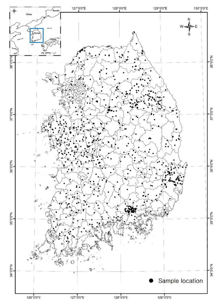
- The database was established by conducting field surveys and water quality analysis of 877 water samples based on the national-scale various water sources, including 167 sampling sites from historically well-known hot springs, mineral waters, and spring waters (from August 2017 to June 2020). Spatial analysis using Kriging interpolation was performed to create a distribution map for 14 mineral components. The distribution maps were prepared with 50 m spatial resolution in raster type, and provided by Geo Bigdata Open Platform service of KIGAM. The spatial distribution of each mineral component showed some relationships with geological (lithology and fault) and regional characteristics, and could be used for drinking water and beverage industry (beverages, alcoholic beverages, teas, coffee, etc.) by providing the various information on the occurrence of natural Good-Water. We plan to continuously update information on Good-Water source to increase spatial resolution and secure its representativeness at each location.
 First
First Prev
Prev


Editorial Office of GEO DATA

#816, 8-13, Gwangpyeong-ro 56-gil, Gangnam-gu, 06367 Seoul, South Korea
Tel: +82-2-6677-5682 E-mail: geodata@gaidas.org
Corporate registration number: 780-82-00418