
Articles
- Page Path
- HOME > GEO DATA > Volume 5(3); 2023 > Article
-
Original Paper
드론 원격탐사를 활용한 벼 성장 모니터링 연구 -
이진형1
 , 이승국2,*
 - A Study on Rice Growth Monitoring Using Drone Remote Sensing
-
Jinhyeong Lee1, Seungkuk Lee2,*
-
GEO DATA 2023;5(3):207-212.
DOI: https://doi.org/10.22761/GD.2023.0019
Published online: September 22, 2023
1학부생, 부경대학교 지구환경시스템과학부, 부산광역시 남구 용소로 45, 48513, 대한민국
2조교수, 부경대학교 지구환경과학과, 부산광역시 남구 용소로 45, 48513, 대한민국
1Undergraduate, Department of Global Environmental Systems Science, Pukyong National University, 45 Yongso-ro, Nam-gu, 48513 Busan, South Korea
2Assistant Professor, Department of Global Environmental Systems Science, Pukyong National University, 45 Yongso-ro, Nam-gu, 48513 Busan, South Korea
- Corresponding Author Seungkuk Lee Tel: +82-51-629-6627 E-mail: seungkuk.lee@pknu.ac.kr
Copyright © 2023 GeoAI Data Society
This is an Open Access article distributed under the terms of the Creative Commons Attribution Non-Commercial License (http://creativecommons.org/licenses/by-nc/3.0/) which permits unrestricted non-commercial use, distribution, and reproduction in any medium, provided the original work is properly cited.
- 485 Views
- 20 Download
Abstract
- Rice paddy is one of the key crops of Korean agriculture and it has long been regarded as an important crop. Due to the high self-sufficiency of rice in Korea, the need to establish systematic rice paddy field data is increasing, and rice paddy research using remote sensing is being conducted several times in Korea. The optical satellite remote sensing method faces difficulties in data acquisition due to the abundance of clouds caused by the summer monsoon season, a characteristic of the domestic climate. However, the drone remote sensing method equipped with an optical sensor has the advantage of being able to freely acquire data, avoiding periods with high cloud cover. In this study, a drone equipped with a multispectral optical sensor was utilized to measure the height of rice paddy. Compared to satellites, drones provide the advantage of flexible timing for observations, allowing for the acquisition of high-frequency time-series data according to specific preferences. In this study, we seek to obtain values related to rice growth rates by analyzing optical data acquired through drone remote sensing. The DJI MAVIC 2 PRO drone was employed, and the Metashape program was utilized to generate a highresolution digital elevation model (DEM) from optical data. After the harvest period, rice-free rice paddy data were assumed to be digital terrain model (DTM), the height of the rice paddies. During the rice growth period, a digital surface model (DSM) was generated from drone imagery, and by calculating the difference between DSM and DTM, the height and growth of the rice plants were observed. Using network GPS measurement data, we validated monthly DEM models. This allowed us to anticipate the acquisition of precise rice growth data throughout the year, from planting to harvest.
- 한국 농업의 핵심 작물로 손꼽히는 벼는 예로부터 중요한 농작물로 여겨져 왔다. 쌀의 식량 자급률이 높은 한국의 특성상 체계적인 벼농사 데이터 구축의 필요성이 증가하고 있으며, 국내에서 여러 차례 원격탐사를 이용한 벼 농사 연구가 진행되고 있다(Lee et al., 2017; Park et al., 2010). 광학 인공위성 원격탐사 방법은 국내 기후 특성상 여름철 장마 때문에 많은 구름으로 데이터 취득에 어려움이 있다(Kim et al., 2010; Statistical Training Institute, 2018). 하지만 광학센서를 탑재한 드론 원격탐사 방법은 구름이 많은 시기를 피해 자유롭게 데이터를 취득할 수 있는 장점이 있다. 본 연구에서 다분광 광학센서를 탑재한 드론을 이용하여 벼의 높이를 측정하였다. 본 연구에서는 드론 원격탐사로 획득한 광학 데이터를 분석하여 벼 성장치에 대한 값을 얻고자 한다. 이를 통해 모내기부터 추수까지 한 해 동안의 정밀한 벼의 성장 데이터 취득을 기대를 할 수 있었다.
1. 서론
- 김해시 화목동 김해 평야 일부분이며, 128° 51’E-128° 52’E, 35° 11’N-35° 12’N에 위치하는 1×1 km 범위로 연구 지역을 설정하였다(Fig. 1). 김해시는 해양성 온대 기후 지역으로 사계절 구분이 뚜렷하고, 남해의 영향을 많이 받아 전국에서 가장 온화한 편이다. 연평균 기온은 15도 내외이며, 평균 강수량은 1,200 mm로 대한민국 평균 강수량과 비슷하다.
2. 연구지역
- 본 연구에서 구축된 데이터는 연구지역을 DJI MAVIC 2 PRO 드론(DJI, Nanshan, China)을 이용하여 촬영하였고 digital elevation model (DEM)을 생성하였다. DJI MAVIC 2 PRO 드론을 활용하였으며, Metashape 프로그램을 이용하여 광학 데이터 자료로 고해상도 DEM을 생성하였다. 추수 시기가 지난 후 벼가 없는 논 데이터 자료를 논의 지형 높이인 digital terrain model (DTM)이라 가정하였다. 벼가 성장하는 동안 드론 촬영 시기의 digital surface model (DSM)을 생성하여 DSM과 DTM의 차분을 통해 벼의 높이와 성장치를 관측하였다. Network GPS 측정 데이터를 이용하여 월별 DEM을 검증하였다.
- 3.1 드론 촬영
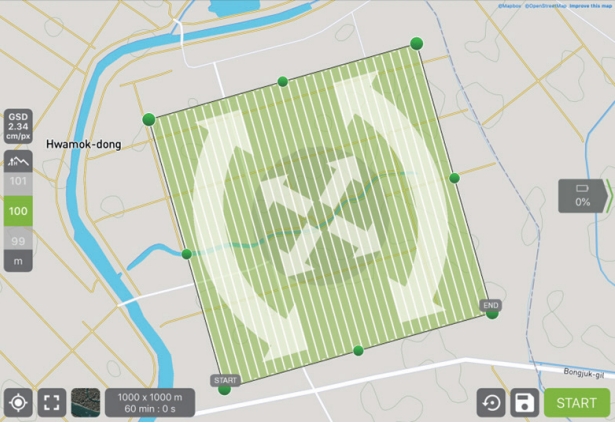
- 드론은 인공위성에 비해 좁은 field of view (FOV)를 가지고 있으며 제한적 배터리 사용 시간 때문에 비행 시간이 짧다. 하지만 드론은 촬영 시기를 자유롭게 지정할 수 있어서, 높은 촬영 빈도 수를 갖는 시계열 데이터 확보가 가능하다. 또한 구름과 강우 시기를 피해 데이터를 취득할 수 있는 장점이 있다. 촬영에 사용한 드론은 DJI MAVIC 2 PRO이고 촬영 범위는 ~1 km2, 촬영 중복률은 80%, 고도는 100 m로 촬영하였다. Pix4D capture 프로그램을 사용해 2D grid 방식으로 경로를 설정하였다(Fig. 2). 2D grid 방식은 비교적 평평한 표면에서 빠르게 찍을 수 있는 비행이고 동일한 범위를 경로를 수직으로 차이를 두고 두 차례에 걸쳐서 촬영하였다. 촬영 시기는 2020년 9월 28일과 2020년 12월 3일 총 2회에 걸쳐 촬영을 진행하였다. 연구 지역 1회 촬영 시간은 약 2시간 30분 정도 소요되었다. 영상 보정을 위해 13개의 보정점을 network GPS로 측정하여 보정 작업에 사용하였다. 보정점은 연구지역상의 도로에 위치한 특징점이나 스프레이로 표시하여 드론 영상에서 식별 가능하였다.
- 3.2 드론 자료 처리
- 촬영한 드론 사진을 이용해서 DEM을 만들기 위해 Metashape 프로그램을 이용하였다(Agisoft, 2023a). Metashape는 대상물을 다각도에서 촬영한 영상으로부터 3차원 포인트 클라우드(point cloud) 및 mesh를 자동으로 생성하는 범용 소프트웨어이다. 또한 카메라 내/외부 표정 요소 산출, 지상기준점 입력, DEM 생성, 정사 영상 및 정사 모자이크 생성 등을 자동화하여 항공사진측량 및 도화 분야에도 널리 활용되는 프로그램이다. 대용량 영상의 처리 시간을 단축하기 위하여 CPU, GPU, network cluster, cloud 기반 병렬 처리를 지원한다.
- Metashape 자료 처리 순서는 이미지 input & 정렬, mesh 생성, 기하보정 및 곡률보정, dense cloud 제작, depth math 제작, DEM 제작, 정사 영상 제작순으로 진행하였다. 이미지 삽입 단계의 align photos 작업은 작업할 날짜의 이미지 전체에서 중첩된 이미지 사이의 일치하는 특징점을 찾아 사진에 대한 카메라 위치를 추정하고 cloud 모델을 구축하였다. 다음으로 mesh를 만드는 과정에서 추출된 특징점들을 기반으로, 위·경도 및 높이 값에 맞춰서 제작하였다. 연구 지역에 드론 촬영을 할 때 network GPS를 사용하여 측정하였던 점들 중 13개를 보정점으로 사용하여 기하보정 작업을 실행하였다. 기준점(tie point)들의 위치를 각각의 사진에서 맞게 조정해 주었다. 그 다음 과정은 곡률보정 & 기하보정 작업을 실시한 후 추정된 카메라 위치를 기반으로 프로그램이 각 카메라의 깊이 정보를 계산하여 하나의 조밀한 포인트 클라우드를 결합하는 dense cloud 작업을 실행하여 3차원 공간 상의 point 집합체를 제작하였다. 이후 최종적으로 연구에 사용되는 DEM을 제작하였다(Agisoft, 2023b).
- 3.3 차분 DEM
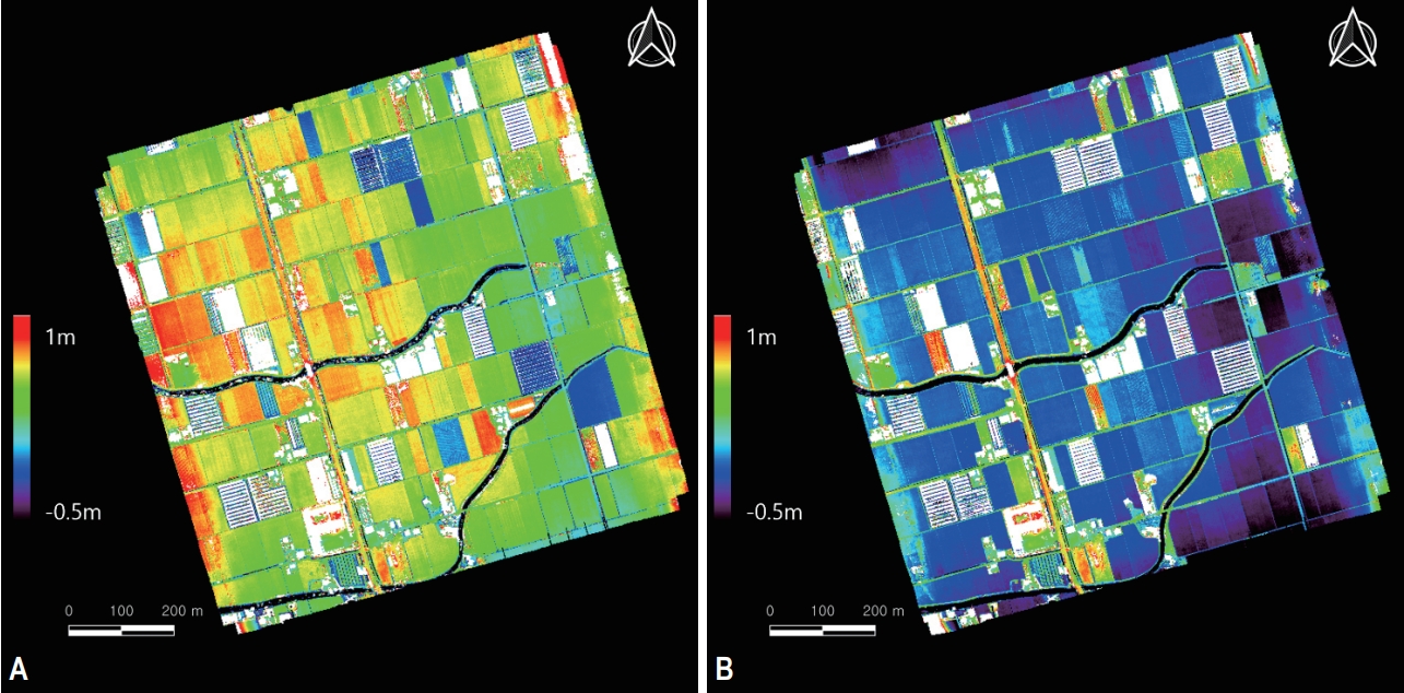
- 본 연구의 목적을 달성하기 위해서 벼가 있는 시기의 DEM과 그 지역의 지면 높이인 DTM을 필요로 한다. 2020년 9월 28일, 2020년 12월 3일 총 2회의 촬영 시기 중에 두 번째 촬영한 2020년 12월 3일의 데이터는 추수가 지난 후의 데이터이기 때문에 지면 높이와 동일하게 사용할 수 있을 것이라 가정하고 본 연구의 DTM으로 사용하기로 하였다. DEM의 공간해상도는 9 cm이고 좌표계는 EPSG:4326을 사용하며 GeoTIFF (.tif) 형태이다.
3. 연구 방법
- 그림 (A), (B)는 생성된 DEM, DTM을 각각 컬러 스케일(최소 -0.5 m, 최대 1.0 m)을 넣은 이미지이다(Fig. 3, Supplementary Figs. 1, 2).
- 앞서 생성한 DEM과 DTM을 차분하는 과정을 수행하기 전에 생성한 모델들을 사용할 수 있는지 검증하는 작업이 필요하여 현장에서 Network GPS를 이용하여 조사하였던 정점 38개의 위·경도와 높이 값을 검증점으로 사용하여 검증 과정을 수행하였다. 검증 결과 DEM과 DTM 모두 R2값이 0.98 이상으로 연구에 수행하기에 적합한 결과를 도출하였다(Table 1). Fig. 4는 검증 작업을 수행한 결과 그래프이다. X축은 Network GPS의 높이 값이고 Y축은 생성한 DEM의 높이 값이다.
- 프로그래밍 언어인 IDL을 사용하여 검증 작업을 수행한 2020년 9월 28일의 DEM에서 2020년 12월 3일의 DTM을 차분하는 과정을 수행하였다(Fig. 5, Supplementary Fig. 3). 12월 3일의 DTM에는 벼가 없는 높이이기 때문에 차분한 DEM에 높이에 따른 컬러 스케일(최소: 0.0 m, 최대: 1.0 m)을 넣었을 때 9월 28일의 벼 높이를 정량적으로 추출할 수 있을 것이라 기대하였다.
4. 결과
- 본 연구에서는 드론 촬영을 통해 만들어낸 DEM을 기반으로 김해시 화목동 김해 평야의 벼의 높이를 추출하였다. 2번의 시기에 걸쳐 촬영한 이미지를 통하여 DEM과 DTM을 생성하여 2020년 9월 28일의 벼 높이 값을 스케일을 통하여 나타낼 수 있었다. 본 연구를 통하여 모내기 시작일부터 추수일까지의 벼의 성장치를 시계열 데이터로 나타낼 수 있을 것이라 기대할 수 있다. 이러한 원격탐사를 통한 연구가 계속 진행되어 한 지역의 식생량 추정 혹은 벼의 높이를 월별로 추출하는 연구를 진행할 수 있을 것이다.
5. 결론 및 토의
-
Conflict of Interest
On behalf of all authors, the corresponding author states that there is no conflict of interest.
-
Funding Information
This research was supported by “Autonomous Creative Academic Research Grant” of Pukyung National University (2021).
-
Data Availability Statement
The data that support the findings of this study are openly available in GEO DATA at https://doi.org/10.22761/GD.2023.0019.
Notes
Supplementary Material
Supplementary Fig. 1.
Supplementary Fig. 2.
Supplementary Fig. 3.


| September 28, 2021 DEM | December 3, 2021 DTM | |
|---|---|---|
| R2 | 0.978 | 0.982 |
| RMSE (m) | 0.029 | 0.027 |
- Agisoft (2023a) Aerial data processing (with GCPs) - orthomosaic & DEM generation https://agisoft.freshdesk.com/support/solutions/articles/31000153696 Accessed 3 May 2023
- Agisoft (2023b) Agisoft Metashape user manual professional edition, version 2.0. Agisoft LLC, Saint Petersbur
- Kim B, Park M, Song S, Min B (2010) A pilot study on estimating rice acreage with satellite images. Korea Rural Economic Institute, Naju, 115p
- Lee KD, Park CW, Na SI, Jung MP, Kim J (2017) Monitoring on crop condition using remote sensing and model. Korean J Remote Sens 33(5):617–620
- Park M, Ham B, Min B, Kim BS (2010) Estimation of rice acreage in the Dangjin province by using Kompsat-2 satellite images. J Rural Dev 33(3):1–17
- Statistical Training Institute (2018) Utilization of remote sensing technology for development of agricultural statistics in North Korea. http://sti.kostat.go.kr/window/2018a/main/2018_sum_2.html Accessed 16 Aug 2023
References
Appendix
Metadata for Dataset
| Sort | Field | Subcategory#1 | Subcategory#2 |
|---|---|---|---|
| Essential | *Title | A study on rice growth monitoring using drone remote sensing | |
| *DOI name | https://doi.org/10.22761/GD.2023.0019 | ||
| *Category | Farming | ||
| Abstract | |||
| *Temporal Coverage | 2021/09/28 to 2021/12/03 | ||
| *Spatial Coverage | 128° 51’E to 128° 52’E, 35° 11’N to 35° 12’N | ||
| *Personnel | Name | Seungkuk Lee | |
| Affiliation | University of Pukyong | ||
| seungkuk.lee@pknu.ac.kr | |||
| *CC License | CC BY | ||
| Optional | *Project | Research Grant of Pukyong National University (2021) | |
| *Instrument | DJI MAVIC 2PRO |
Figure & Data
References
Citations
 PubReader
 ePub Link
 Cite
Cite


#816, 8-13, Gwangpyeong-ro 56-gil, Gangnam-gu, 06367 Seoul, South Korea
Tel: +82-2-6677-5682 E-mail: geodata@gaidas.org
Corporate registration number: 780-82-00418
