
Previous issues
- Page Path
- HOME > Articles and Issues > Previous issues
- Volume 1(1); December 2019
-


Articles
- Meteorological and sea surface water measurement data from Icebreaker Research Vessel ARAON for 2010-2019 Arctic research expeditions
- Dongseob Shin, Suhwan Kim, HyungGyu Choi, Dongchan Joo
- GEO DATA. 2019;1(1):1-6. Published online December 30, 2019
- DOI: https://doi.org/10.22761/DJ2019.01.01.001

- 277 View
- 12 Download
-
 Abstract
 PDF
PDF - Despite of its economic and scientific significances with mineral resources, the Northern Sea Routes, and climate change, the Arctic Ocean has been a challenge for long-term continuous environmental observations. Since its inception in 2009, the ice-breaker research vessel ARAON has been conducting an annual expedition in the Arctic Ocean for the last 10 years from 2010. All the Arctic expeditions have been carried out mainly in August-September when the sea ice extent shrinks and the thickness becomes relatively thin around the Bering Sea, Chukchi Sea, Beaufort Sea, and high latitudes over the Russia, the US, and Canada. IBRV ARAON can conduct research activities through a variety of research equipment such as on-board meteorological data and surface temperature & salinity monitoring data of seawater. In this study, meteorological observation elements including solar radiation, air temperature, relative humidity, wind speed, and wind direction are presented. In addition, sea surface water temperature and salinity monitoring elements including water temperature, salinity, conductivity, and sound speed are presented.
- Hyperspectral Irradiance Data for a Comparison and an Analysis of Optical Satellite Spectral Observation: Based on Seogwipo Forest Flux Tower
- Hongtak Lee, JongMin Yeom
- GEO DATA. 2019;1(1):7-12. Published online December 30, 2019
- DOI: https://doi.org/10.22761/DJ2019.01.01.002

- 361 View
- 7 Download
-
Abstract
PDF
- Comparison with ground-truth data is essential for developing and applying remote sensing algorithm towards the Earth surface. Unfortunately, major sources of domestic ground-truth data are depending on fieldcampaign with limited period because of insufficient all-time observation facilities within a domestic region. Korea Aerospace Research Institute, KARI, is planning to construct and operate surface observation tower to provide remote sensing infrastructure. This study was conducted as a pilot program of the observation tower construction and targeted to observe surface reflectance. The observation was made for about 21 months from May 2017. Two hyper-spectroradiometers were installed on top of a forest flux tower at Mt. Halla to measure hyperspectral up/down-welling irradiance, and surface reflectance was derived simply from their ratio. The derived surface reflectance was compared to surface reflectance values estimated from LANDSAT8 VNIR images, and the two surface reflectances coincided while showing effectiveness of the derived surface reflectance. The data acquired from this study would be able to provide background information for the expected surface observation tower, as well as actual ground-truth data for remote sensing application upon Mt. Halla area.
- Red tide dataset in the waters around the Korean Peninsula
- Jisun Shin, Euihyun Kim, Keunyong Kim, Joo-Hyung Ryu
- GEO DATA. 2019;1(1):13-24. Published online December 30, 2019
- DOI: https://doi.org/10.22761/DJ2019.01.01.003

- 390 View
- 22 Download
-
Abstract
PDF
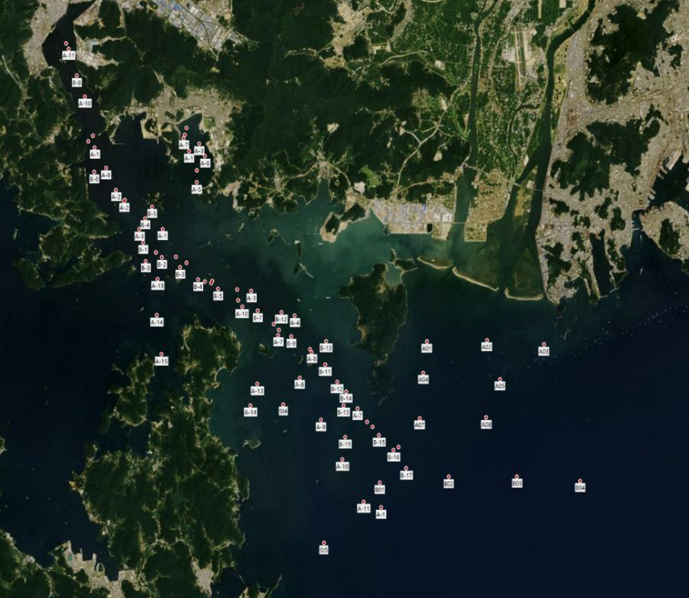
- Red tide blooms are increasing worldwide. Since 1995, Margalefidium polykrikoides blooms have occurred frequently in the waters around the Korean Peninsula. These blooms generally appear first on the South Sea of Korea in summer. When they occur on a large scale, they extend to the East Sea of Korea and the West Sea of Korea, causing great damage to fisheries and marine ecosystems. Harmless red tide can also adversely affect the environment of the waters by causing oxygen depletion in waters when occurring at high density. Currently, the National Institute of Fisheries Science (NIFS) is providing the daily red tide report based on M. polykrikoides red tide species. This report contains red tide species, location, and cell abundance information, but is limited to use as cell abundance data based on exact location. In addition, the waters around the Korean peninsula have different characteristics, so that the optical characteristics and seawater environment are different for each water. In the East Sea in Aug. 2013, the West Sea in Aug. 2016, the South Sea in Aug. 2018, and the South Sea in Aug. and Sep. 2019, during red tide season, dataset were obtained for red tide cell abundance, spectrum, chlorophyll concentration, and suspended particulate matter concentration. Noctiluca scintillans species were observed in the field survey conducted in 2016, and M. polykrikoides was mainly found in the other field surveys. Location-based red tide cell abundance data and seawater environment information obtained during red tide occurrence will be useful data for the construction of red tide warning system to reduce damage due to red tide blooms.
- Trace element determination result for the USGS standard rocks BCR2, BIR1a and GSP2 during 2015-2019
- Seung-Gu Lee, Youngji Ha, GiUn Han
- GEO DATA. 2019;1(1):25-28. Published online December 30, 2019
- DOI: https://doi.org/10.22761/DJ2019.01.01.004

- 202 View
- 6 Download
-
Abstract
PDF
- Trace element concentrations of the US Geological Survey's basalt standards (BCR2, BIR1a) and a granite standard (GSP2) were determined during five years from 2015 to 2019. These data will be helpful for judging data quality of trace element concentrations determined for the geochemical interpretation at KIGAM trace-isotope team. In addition, our data also include measurements of some elements whose recommendation values are not available in the US Geological Survey report.
- Chlorophyll and Total Suspended Materials Concentrations and Remote Sensing Reflectance Data measured at the Red Tide Area of Jinhae, Geoje, and East Sea during August from 1998 to 2003 and August 2013
- Jeong-Eon Moon, Tai-Hyun Han, Kwang-Seok Kim, Deuk-Jae Hwang, Jae-Hyun Ahn, Jong-Kuk Choi, Joo-Hyung Ryu, Young-Je Park
- GEO DATA. 2019;1(1):29-37. Published online December 30, 2019
- DOI: https://doi.org/10.22761/DJ2019.01.01.005
- 655 View
- 8 Download
-
Abstract
PDF
- The chlorophyll and total suspended materials concentrations and remote sensing reflectance data were observed for red tides occurring every summer in waters around the Korean Peninsula. In observation area and date, the field survey were performed (1) in the Jinhae and Geoje coasts during August 1998, August 1999, August 2001, and August 2003, (2) in East Sea coast during August 2013. The remote sensing reflectance data were obtained from portable spectroradiometer. The chlorophyll concentration data were obtained from spectrophotometric method and the total suspended materials concentration data were obtained from filter-weight difference method. The remote sensing reflectance data were validated using Moon et al.(2012). The chlorophyll concentration data were validated using baseline correction and subtraction of 750 nm value, and the total suspended materials concentration data were validated using variation of humidity.
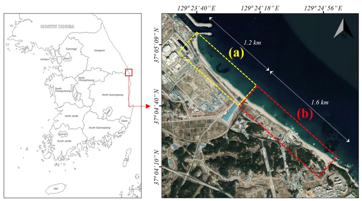
- Unmanned aerial vehicle remotely sensed datasets, a reference dataset for coastal topography change and shoreline analysis
- Bumjun Kim, Keunyong Kim, Joo-Hyung Ryu
- GEO DATA. 2019;1(1):38-45. Published online December 30, 2019
- DOI: https://doi.org/10.22761/DJ2019.01.01.006
- 352 View
- 18 Download
-
Abstract
PDF
- To analyze tendency of temporal and spatial change of coast using long-term topography and shoreline change data is important. In this study, high-resolution digital elevation model and orthorectified image data were generated using rotary-wing UAV(unmanned aerial vehicle) system for coastal topography and shoreline change analysis. The UAV system has advantage of low cost and high efficiency compared to satellite remote sensing platform so UAV system easily acquire time series image data. The spatial resolution of generated digital elevation model and orthorectified images are very high, in centimeter. Therefore, the above image data can be used in various fields of remote sensing and geography such as detailed coastal topography.
- Geothermal Data of Chungcheong-do
- Jae-Hong Hwang, Hyeong-Chan Kim
- GEO DATA. 2019;1(1):46-49. Published online December 30, 2019
- DOI: https://doi.org/10.22761/DJ2019.01.01.007

- 260 View
- 8 Download
-
Abstract
PDF
- Preexistence geothermal representation technology has been used to build a GIS database for accurate geothermal information. Based on this, Chungcheong-do was analyzed. GIS composition and statistical analysis of Chungcheong-do were established and regional targets were calculated. Geothermal representation was performed through a large number of borehole data. Rock characterization of Chungcheong-do was performed using borehole data and rock samples. Therefore, we attempted to summarize the geothermal statistics and create a geothermal theme map for regional analysis and evaluation of geothermal characteristics of Chungcheong-do.
Opinion
- A Proposal for a Standardized Fault Description Format to Study Active Intraplate Tectonics in the Korean Peninsula
- Youngbeom Cheon, Jin-Hyuck Choi, Seung Ryeol Lee
- GEO DATA. 2019;1(1):50-57. Published online December 30, 2019
- DOI: https://doi.org/10.22761/DJ2019.01.01.008
- 277 View
- 7 Download
- 1 Citations
-
Abstract
PDF
- Intraplate faulting and the resultant earthquakes are not well understood because of their complex distribution, long period of seismic recurrence, and poor exposure of surface rupture. Pre-existing weaknesses should be studied to understand intraplate faulting and earthquakes. We are developing a long-term project to understand Korean-type intraplate fault behavior and recurrence intervals. As the first step, we will establish an integrated system for production, analysis, and management of fault data related to active crustal deformation. Here we propose a new format for fault data description and management.
-
Citations
Citations to this article as recorded by
- Understanding the distribution and internal structure of the main core of the Yangsan Fault Zone: Current trends and future work
Youngbeom Cheon, Jin-Hyuck Choi, Yire Choi, Hankyung Bae, Ki-Hwan Han, Moon Son, Sung-Ja Choi, Chung-Ryul Ryoo
Journal of the Geological Society of Korea.2020; 56(5): 619. CrossRef
- Understanding the distribution and internal structure of the main core of the Yangsan Fault Zone: Current trends and future work
Articles
- Characteristics of Fish Fauna Data in jin Island, Korea
- Heenam Yoon, Yongsu Kwon, Manseok Shin, Kidong Kim
- GEO DATA. 2019;1(1):58-63. Published online December 30, 2019
- DOI: https://doi.org/10.22761/DJ2019.01.01.009

- 233 View
- 11 Download
-
Abstract
PDF
- The fish community in the Jin Island (Jindo, Jisan, Munnae, Yulri, 1/25,000 scale) was investigated with the data collected through the 3rd National Ecosystem Survey from April to October in 2012. During the period, 25 species belonging to 7 families were collected. There were 11 biological resources subject to the approval of outbound transfer, including Squalidus gracilis majimae, Abbottina rivularis, Aphyocypris chinensis, Hemiculter eigenmanni, Rhodeus ocellatus, Iksookimia hugowolfeldi, Iksookimia koreensis, Trachidermus fasciatus, Monopterus albus, Macropodus ocellatus and Oryzias latipes. The dominant species was Pseudorasbora parva(26.3%), and the subdominant spaecies was Carassius auratus(16.0%). Background: In Korea, from 1989 National Ecosystem Survey (NES) was conducted by ministry of environment for every 10 years to cover whole south Korea in 1/25,000 scale. The scope of NES including 8 taxa – vegetation, plant, fish, macro invertebrate, insect, birds, amphibian & reptile, mammal and geomorphology. With the results of ecosystem survey we build up species and ecosystem database based on GIS environment. Ecosystem database is becoming very necessary to understand origins and relationship between human and nature and also to reduce ecosystem disturbance. New information: An ecological information platform can play important roles as a computing system to collect knowledge, distributed research findings and separated data from researchers. We designed and developed ecological information portal service (EcoBank 1.0) for collecting and providing ecological information for various stake-holders. Then, we developed basic functions to analyze ecosystem for each stake-holders (researchers, general public and policy makers). We successfully designed a computing system named EcoBank supporting the functions of Digital Object Identifier (DOI) publish and data quality management.
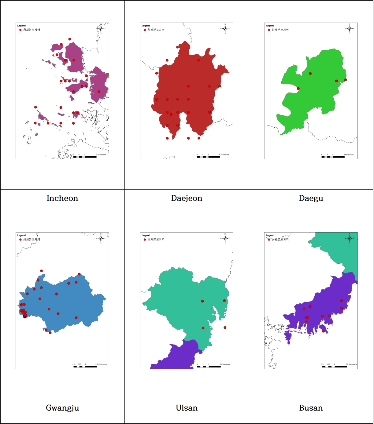
- Distribution Characteristics of Eurasian tree sparrow in the City–On 6 metropolitan cities (Incheon, Daejeon, Daegu, Gwangju, Ulsan, Busan)
- Woo Yuel Kim, Sungeun Jung, Jun Seok Lee, Sang-Yeon Lee, Seung Se Choi, Kwang Jin Cho
- GEO DATA. 2019;1(1):64-68. Published online December 30, 2019
- DOI: https://doi.org/10.22761/DJ2019.01.01.010
- 295 View
- 7 Download
-
Abstract
PDF
- Eurasian tree sparrow data from the 4th National Ecosystem Survey (2014 ~ 2018) were used for sparrows, which are known to decrease by about one third over 40 years. Data on altitude and land type among GIS factors in the Eurasian tree sparrow Recorded 6 Metropolitan City(Incheon, Daejeon, Daegu, Gwangju, Ulsan, Busan) of Republic of Korea were generated. As a result, altitudes and land types were generated for 578 Eurasian tree sparrow.
 First
First Prev
Prev


Editorial Office of GEO DATA

#816, 8-13, Gwangpyeong-ro 56-gil, Gangnam-gu, 06367 Seoul, South Korea
Tel: +82-2-6677-5682 E-mail: geodata@gaidas.org
Corporate registration number: 780-82-00418